|
|
|
Metadata
|
|
ID
|
07SWL01
|
|
Also Known As
|
B-1-07-LA
|
|
Abstract
|
United States Geological Survey, St. Petersburg, Florida,
Coastal and Marine Geology Program. Chief Scientist: Robert
Morton. Coring data (vibratingcore, pushcore, GPS, coring
barge) of field activity 07SWL01 (B-1-07-LA) in Louisiana
Delta Plain (Lafourche and Jefferson Parishes) from
09/04/2007 to 09/14/2007
|
|
Organization
|
United States Geological Survey, St. Petersburg, Florida, Coastal and Marine Geology Program
|
|
Project/Theme
|
Historical Subsidence and Wetland Loss, Louisiana Coastal Plain
|
|
Chief Scientist
|
Robert Morton
|
|
Activity Type
|
Coring
|
|
Platform
|
Barge
|
|
Area of Operation
|
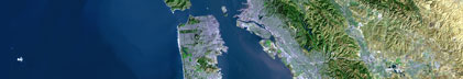
Louisiana Delta Plain (Lafourche and Jefferson Parishes)
|
|
Location map
|

|
|
Bounding Coordinates
|
29.64452
-90.17008 -90.02483
29.60367
|
|
Ports
|
LEAVE Jean Lafitte or Ironton, LA
ARRIVE Port Fourchon, LA
|
|
Dates
|
09/04/2007 (JD 247) to 09/14/2007 (JD 257)
|
|
Analog Materials
|
No analog holdings.
|
|
Index map

|
|
|
Information Specialist
|
|
|
Crew
|
|
Julie Bernier
|
|
Kyle Kelso
|
|
Chandra Dreher
|
|
|
Equipment Used
|
|
vibratingcore
|
|
pushcore
|
|
GPS
|
|
coring barge
|
|
|
Purpose
|
|
Quantify subsidence and erosion in areas of historical wetland loss
|
|
|
Information to be Derived
|
|
Water depth, elevation, stratigraphy, depth to organic-clastic contact,
|
|
magnitude and rate of subsidence
|
|
|
Summary
|
|
Collected 22 Vibra-cores and 6 shallow Push (hand) cores
|
|
|
Notes
|
|
|
Got Help?
|
For 07SWL01, we would appreciate any information on -- analog materials, contract, days at sea, dive count, funding, kms of navigation, national plan, NGDC Info, owner, project number, publications, scanned materials, seismic description, station count, station description, submersible, tabulated info.
|
|