|
|
|
Metadata
|
|
ID
|
A-1-03-HW
|
|
Abstract
|
United States Geological Survey, National Mapping Division,
Flagstaff,United States Geological Survey, Menlo Park,
California. Chief Scientist: Pat Chavez. Video data
(underwatercamera, GPS, underwatertelevision) of field
activity A-1-03-HW in Molokai, Hawaii from 02/10/2003 to
02/12/2003
|
|
Organization
|
United States Geological Survey, National Mapping Division, Flagstaff
United States Geological Survey, Menlo Park, California
|
|
Project/Theme
|
Coral Reefs
|
|
Chief Scientist
|
Pat Chavez
|
|
Activity Type
|
Video
|
|
Platform
|
Alyce C
|
|
Area of Operation
|
Molokai, Hawaii
|
|
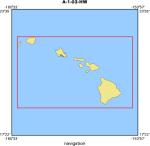
Location map
|
|
|
Bounding Coordinates
|
22.25000
-160.25000 -154.25000
18.75000
|
|
Ports
|
leave Molokai
arrive Molokai
|
|
Dates
|
02/10/2003 (JD 041) to 02/12/2003 (JD 043)
|
|
Analog Materials
|
No analog holdings.
|
|
Index map

|
|
|
Information Specialist
|
|
|
Crew
|
|
Pat Chavez
|
Chief Scientist, USGS NMD - Flagstaff
|
|
Miguel Velasco
|
Video collection, USGS NMD - Flagstaff
|
|
Ann Gibbs
|
Video collection, USGS CMG - WR
|
|
Joe Reich
|
Ship Captain,
|
|
|
Equipment Used
|
|
underwatercamera
|
|
GPS
|
|
underwatertelevision
|
|
|
Purpose
|
|
Collect geographically referenced video of coral reefs for bottom type
|
|
classification.
|
|
|
Information to be Derived
|
|
Bottom type classification
|
|
|
Summary
|
|
|
Got Help?
|
For A-1-03-HW, we would appreciate any information on -- analog materials, contract, days at sea, dive count, funding, kms of navigation, national plan, NGDC Info, notes, owner, project number, publications, scanned materials, seismic description, station count, station description, submersible, tabulated info.
|
|