|
|
Region: |
Latin America & Caribbean |
||
| Contact: | Jean
N. Weaver, jweaver@usgs.gov |
||
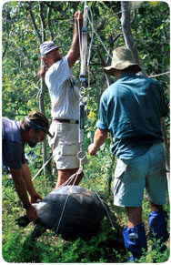
| Projects: | Conservation
Biology of Giant Tortoises in Galapagos |
|
|
| Overview: | The USGS historically has been active in South America, a region that has long been involved in the mineral and mining sectors. USGS has collaborated with counterpart agencies in Bolivia and Venezuela to produce mineral resource assessments of the Alti Plano in Bolivia and in the eastern part of Venezuela. Currently, workshops on human health issues related to the environment are underway in Venezuela and Chile. Suriname and Guyana are interested in promoting collaborative activities. Oil and gas assessments are of interest as well. All South American coal-bearing countries have been involved in the World Coal Inventory project. Collaborative efforts focused on hydrology (stream gage monitoring networks), biology (health of the shrimp economy in southern Honduras), and geology (health of coral reefs, landslides, earthquakes, volcanoes), along with data clearinghouse networks, satellite imagery interpretation, and training in Geographic Information Systems (GIS). Much of this work was done in close collaboration with other Federal agencies such as the National Oceanic and Atmospheric Administration (NOAA) and the U.S. Army Corps of Engineers (USACOE).
|
||
|
|
|||
USGS activities within the Caribbean region have not been extensive. The only major on-going project is the Certification of Agriculture Lands in the West Indies project as well as the Caribbean Vegetation Mapping Project. There has been some discussion with the Office of Foreign Disaster Assistance/U.S. Agency for International Development (OFDA/USAID) as well as with the Organization of American States (OAS) on collaborative activities related to hazard mitigation issues. A separate tri-nation project on the North American Magnetic Map in conjunction with Mexico (CRM) and the Geological Survey of Canada (GSC) is scheduled for completion in October 2003.
|
|||

![]() U.S. Department of the Interior |
U.S. Geological Survey
U.S. Department of the Interior |
U.S. Geological Survey
URL: http://international.usgs.gov/regional/reglatiname.htm
Page Contact Information:
Page Contact Information: IP Web Team
Page Last Modified: Wednesday, 25-Jun-2008 10:15:32 EDT