
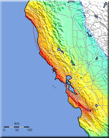
United States National Seismic Hazard Maps
Please read an important note on the use of the new 2008 USGS Hazard Maps before using this data.
USGS Earthquake Hazard Assesment Products and Tools
-
US National, Urban, & Foreign Probabilistic Ground-Motion Maps
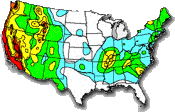
Maps and associated input/output data and documentation for probabilistic hazard maps. More…
-
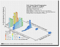
Seismic Design Values for Buildings

An application allowing users to determine design ground motion at a site for various building codes, using latitude/longitude or zip code. In addition, one can display and download a hazard curve or uniform hazard spectrum for a site. More…
-
Custom Mapping and Analysis Tools
The USGS offers a number of on-line web tools that allow an individual to asses which sources pose the greatest hazard in a particular region, look up hazard values using latitude/longitude or Zip code, make customized USGS probabilistic hazard maps for an area of interest, map probability of a given magnitude within a certain distance from a site, and access computer software for seismic hazard analysis. More…
-
U.S. Quaternary Faults
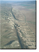
These Web pages contain information on faults and associated folds in the United States that are believed to be sources of M>6 earthquakes during the Quaternary (the past 1,600,000 years). Maps of these geologic structures are linked to detailed descriptions and references. More…
-
Earthquake Hazards 101
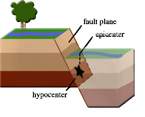
The USGS provides a wealth of explanatory materials for the layperson, including information on concepts behind earthquake maps, the use of probability, what the maps mean, how they are made, and answers to frequently asked questions. More…
-
Deterministic or Scenario Ground-Motion Maps
Maps predict the median level of ground shaking from a particular “scenario” event. They do not take into account the liklihood of that scenario occurring, but they are helpful when assessing the potential impact of a particular event. More…
-
Time-Dependent Earthquake Probability Maps
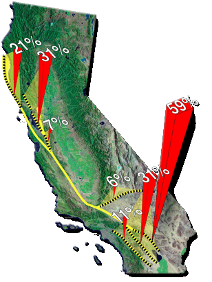
These maps forecast the likelihood of an earthquake rupture occurring during an interval of time in the future. Time-dependent maps are considered research tools and are not currently applied in building codes. More…
