USGS Logo

Line image

EAST SOUTH-CENTRAL SECTION

Please click on gaging station

Station# 07018100, Big River near Richwoods Station# 07017200, Big River at Irondale Station# 07037000, Big Creek at Des Arc Station# 07061500, Black River near Annapolis Station# 07062050, Clearwater Tailwater near Piedmont Station# 07062000, Clearwater Lake near Piedmont Station# 07061900, Logan Creek at Ellington Station# 07067000, Current River at Van Buren Station# 07068000, Current River at Doniphan Station# 07071500, Eleven Point River near Bardley Station# 07066000, Jacks Fork at Eminence Station# 07065495, Jacks Fork at Alley Spring Station# 07065200, Jacks Fork near Mountain View Station# 06928300, Roubidoux Creek above Ft. Leonard Wood Station# 06930000, Big Piney near Big Piney Station# 06930060, Big Piney below Ft. Leonard Wood Station# 06928430, Roubidoux Creek below Ft. Leonard Wood Station# 06933500, Gasconade River at Jerome Station# 06932000, Little Piney Creek at Newburg Station# 07015720, Bourbeuse River near High Gate Station# 07013000, Meramec River near Steelville Station# 07014500, Meramec River near Sullivan East South-Central Missouri Links

Northwest Section North Central Section Northeast Section Central Section Central Section East Central Section Southeast Section East South-Central Section West South-Central Section Southwest Section West-Central SectionMap of Missouri with Links to Real-Time Data

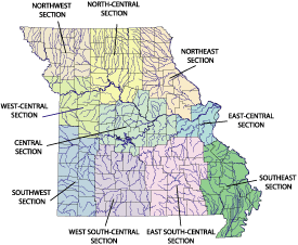
Click map to visit another section

Line image

MO Home Page USGS Home Page Water Home Page Biology Home Page Geology Home Page Mapping Home Page   First Gov Home Page

U.S. Department of the Interior, U.S. Geological Survey
Maintainer: Rita Choate, Webmaster
Updated: August 22, 2003
Privacy Statement || Disclaimer || FOIA || Accessibility
URL: http: missouri.usgs.gov/surfwat/escsection.htm