USGS logo
International Program
Skip Navigation
Home
About
Regions
Search
Contacts
Links
Partners
 

Region: 

Global


Projects:

Global Seismic Network [opens new window]

Map showing Global Seismic Network
Global Seismic Network - Contains 128 seismographic stations in more than 80 countries on all continents.

Global Mineral Resource Assessment - Map showing Afgan mineral resources

Western Hemisphere with GSDI project areas highlightedEastern Hemisphere with GSDI project areas highlighted
Hemisheres with GSDI project areas higlighted

Landsat 7 Worldwide Acquisition Density map.

    World Energy Assessment [opens new window]
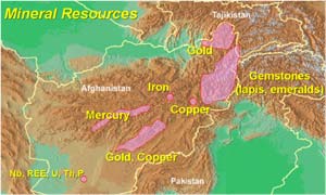
    Global Mineral Resource Assessment [opens new window]
    Global Spatial Data Infrastructure


Landsat International Cooperators
    UNEP/GRID


Other Activities:

U.S. National Committee for the International Hydrological Programme [http://water.usgs.gov/nrp/IHP/]


Home | About | Regions | Partners | Contacts| Search
#
Africa | Asia & Pacific | Canada & Polar | Europe | Global | Latin Ame. & Caribbean | Middle East | Central Eurasia (FSU)

Accessibility FOIA Privacy Policies and Notices

Take Pride in America logo USA.gov logo U.S. Department of the Interior | U.S. Geological Survey
URL: http://international.usgs.gov/regional/global.htm
Page Contact Information: Page Contact Information: IP Web Team
Page Last Modified: Wednesday, 25-Jun-2008 13:57:20 EDT