 Recent Earthquakes in California and Nevada
---> Please visit our reorganized earthquake pages at -
http://quake.usgs.gov/ <---
including new CA-NV pages at -
http://quake.usgs.gov/recenteqs/latest.htm
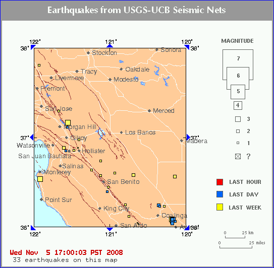
Click on an earthquake on the above map for more information.
Click on an arrow at edge or corner of above map to go to an adjacent map.
Click here to go to index map ||
big earthquake list ||
all earthquakes list
Special maps:
Long Valley ||
Los Angeles ||
San Francisco ||
Parkfield
Map need updating? Try reloading the page to your browser.
Maps are updated within about 5 minutes of an earthquake or once an hour.
Brown lines represent known hazardous faults or fault zones. White lines are roads.
What happens when I click on an earthquake?
Update time = Thu Nov 6 10:00:03 PST 2008
Here are the 30 most recent earthquakes and all M>3 earthquakes on this map...
 MAG    DATE    LOCAL-TIME  LAT     LON    DEPTH    LOCATION
        y/m/d     h:m:s     deg     deg     km
 1.8  2008/11/06 06:47:53 36.846N 121.578W  6.7    4 km ( 2 mi) W   of San Juan Bautista, CA
 1.2  2008/11/06 04:28:43 37.355N 121.721W  7.8    9 km ( 6 mi) E   of Alum Rock, CA
 2.2  2008/11/05 20:03:49 37.162N 121.555W  5.3    9 km ( 5 mi) ENE of Morgan Hill, CA
 1.7  2008/11/05 12:19:41 36.389N 121.035W  0.0   19 km (12 mi) SSE of Pinnacles, CA
 1.3  2008/11/05 08:55:19 36.228N 120.345W 10.8   10 km ( 6 mi) N   of Coalinga, CA
 2.0  2008/11/05 08:30:54 36.037N 120.175W 10.9    5 km ( 3 mi) WNW of Avenal, CA
 2.6  2008/11/05 08:28:47 36.084N 120.178W 13.4    8 km ( 5 mi) NW  of Avenal, CA
 1.9  2008/11/05 08:17:26 36.059N 120.135W 16.9    4 km ( 2 mi) NNW of Avenal, CA
 2.4  2008/11/05 08:11:32 36.080N 120.180W 12.5    8 km ( 5 mi) NW  of Avenal, CA
 3.3  2008/11/05 08:05:49 36.076N 120.171W 14.9    7 km ( 5 mi) NW  of Avenal, CA
 1.3  2008/11/05 01:10:06 36.845N 121.578W  6.3    4 km ( 2 mi) W   of San Juan Bautista, CA
 1.6  2008/11/04 22:56:54 37.115N 121.560W  3.0    5 km ( 3 mi) NE  of San Martin, CA
 2.8  2008/11/04 19:21:39 36.237N 120.358W  9.9   11 km ( 7 mi) N   of Coalinga, CA
 2.0  2008/11/04 17:32:51 36.067N 120.176W 13.0    7 km ( 4 mi) NW  of Avenal, CA
 2.3  2008/11/04 14:32:20 36.884N 121.605W  2.2    3 km ( 2 mi) E   of Aromas, CA
 1.3  2008/11/04 01:53:29 36.047N 120.187W  9.6    6 km ( 4 mi) WNW of Avenal, CA
 3.0  2008/11/04 01:44:25 36.079N 120.181W 13.5    8 km ( 5 mi) NW  of Avenal, CA
 1.2  2008/11/04 01:29:23 37.803N 121.930W 13.4    2 km ( 1 mi) WSW of Blackhawk, CA
 1.2  2008/11/03 15:49:02 36.245N 120.796W  8.5   22 km (14 mi) SSW of New Idria, CA
 1.6  2008/11/02 20:36:28 36.634N 121.239W  7.7   14 km ( 9 mi) NW  of Pinnacles, CA
 1.9  2008/11/02 15:11:42 36.572N 121.118W  9.6    5 km ( 3 mi) NNE of Pinnacles, CA
 1.3  2008/11/02 05:52:29 37.291N 121.671W  0.9   15 km ( 9 mi) E   of Seven Trees, CA
 1.1  2008/11/02 00:51:56 36.737N 121.117W  0.6   19 km (12 mi) ESE of Tres Pinos, CA
 0.9  2008/11/02 00:31:44 36.042N 120.634W  0.1   24 km (15 mi) NW  of Parkfield, CA
 0.9  2008/11/02 00:31:21 36.029N 120.622W  1.8   22 km (14 mi) NW  of Parkfield, CA
 1.2  2008/11/01 22:48:06 36.115N 120.744W  1.2   18 km (11 mi) NE  of San Ardo, CA
 3.1  2008/11/01 20:34:35 37.164N 121.555W  5.4    9 km ( 6 mi) ENE of Morgan Hill, CA
 2.7  2008/11/01 16:44:10 36.579N 120.688W 13.2   18 km (11 mi) N   of New Idria, CA
 3.2  2008/10/31 19:46:32 36.531N 121.918W 10.0    3 km ( 2 mi) S   of Carmel By The Sea, CA
 2.2  2008/10/31 19:12:08 36.558N 120.141W  0.2    7 km ( 4 mi) SE  of San Joaquin, CA
Click here to see this same map with
a complete list of earthquakes.
[Top of this page]
[Special maps:
Long Valley ||
Los Angeles ||
San Francisco ||
Parkfield]
[
Index map ||
big earthquake list ||
all earthquake list ||
glossary of terms ||
top page
]
Data Sources
Northern California - USGS =
U.S. Geological Survey, Menlo Park
Northern California - UCB =
University of California, Berkeley
Southern California - USGS =
U.S. Geological Survey, Pasadena
Southern California - Caltech =
California Institute of Technology
Southern California - UCSD =
University of California, San Diego
Nevada - UNR =
University of Nevada, Reno
US and World - USGS/NEIC =
National Earthquake Information Center
Offshore =
West Coast & Alaska Tsunami Warning Center
...all members of the
Advanced National Seismic System (ANSS)