Hydrology and Remote Sensing Laboratory Site Logo
ARS Home About Us Helptop nav spacerContact Us En Espanoltop nav spacer
Printable VersionPrintable Version     E-mail this pageE-mail this page
Agricultural Research Service United States Department of Agriculture
Search
  Advanced Search
Programs and Projects
Airborne Remote Sensing Basics
ARS Remote Sensing Workshop
OPE3
Crop Condition and Yield Research
Jornada Experiment
Monsoon '90
Soil Moisture Program
Remote Sensing in ARS Workshop 2000
 

1 -
2 -
3 -
4 -
5 -
6 -
7 -
8 -
9 -
10 -
Remote Sensing Basics Logo
 

I. Sources of Imagery

II. Signal-to-Noise Ratio (S/N)

III. Imaging Theory: What to Expect

IV. Simple Tools for Checking Image Data Quality

V. Choice of Spectral Bands

VI. Final Thoughts and Suggestions

VII. Resources and References

Disclaimer

Acknowledgements


Charles L. Walthall

USDA-ARS
Hydrology and Remote Sensing Lab
Beltsville, Maryland

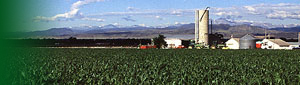
These notes were developed from presentations at an Airborne Remote Sensing Workshop conducted at the National Soil Tilth Laboratory, Ames, IA on November 25-26, 2002. The original presentation was oriented towards users and suppliers of data from a commercially-available small, lightweight, hyperspectral, pushbroom scanner known as the Airborne Imaging Spectroradiometer for Applications (AISA). However the suggestions for first-time data users will apply to imagery acquired by any airborne imaging system. hyperspectral scanner system

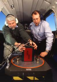
The goal is to provide users and providers of airborne digital imagery with a working philosophy about such data, and some suggestions on how to proceed when a new user is handed a data set for the first time. If you are a first time data user, have a data set, have questions about what to do with a data set first, and need immediate guidance, go directly to section IV. If you have not yet acquired imagery and would like more insight to the process begin with the section on Choice of Spectral Bands.

This presentation assumes that the user has working knowledge of the basic elements of an image processing package such as the following commercially-available systems:

ENVI http://www.rsinc.com/
ERDAS http://gis.leica-geosystems.com/
PCI http://www.pci.on.ca/
TNT-MIPS http://www.microimages.com/
or the following free systems:
NIH Image http://rsb.info.nih.gov/nih-image/
Multispec http://dynamo.ecn.purdue.edu/~biehl/MultiSpec/

Contents


WebMaster   |  Content Manager

[1]     2     3     4     5     6     7     8     9     10     Next >>

     
Last Modified: 09/09/2005
ARS Home | USDA.gov | Site Map | Policies and Links 
FOIA | Accessibility Statement | Privacy Policy | Nondiscrimination Statement | Information Quality | USA.gov | White House