Black River Area of Concern

Background
|
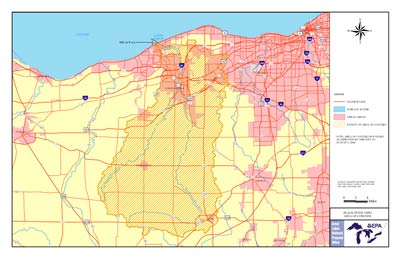 Black River AoC Boundary Map (PDF 604Kb 1 page) (click on map to view in separate window) Black River Shape File
|
Background

|
|
|
|


The Black River is located in north-central Ohio and drains over
467 square miles (1,210 km2) of land. Although flowing primarily in
Lorain County the watershed does include drainage from Medina,
Ashland, Huron and Cuyahoga Counties. Fifty-one percent of the land
within the AoC is used for agriculture, while only 1% is truly
industrial. Between these two extremes are rural (38%), urban
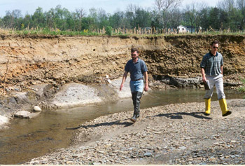
residential (7%) and commercial land (3%). Over the past few
decades, water and sediment quality have improved in the Black
River. The contaminated sediments were remedially dredged and
impacts from point sources (factories, waste water treatment plants,
etc.) have been significantly reduced. Now, the Black River, like
many major rivers across the country, is being threatened by major
nonpoint source impacts coming from the entire watershed. These
impacts are caused by the way the landscape is used for urban,
suburban and rural activities. Land disturbances associated with
high residential growth rate and intensive agricultural practices
are a particular problem. The predominately agricultural sub-basins
in the upper Black River watershed are witnessing more than 20% of
their land eroding at a rate of 5 tons/acre/year or more. Over
17,000 acres are eroding at "excessive" levels in these areas with
cropland accounting for 82% of this number.
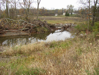
Properly managing urban, suburban and rural land use practices
throughout the Black River Area of Concern including the enhancement
and protection of the riparian corridors and wetlands will improve
the quality and productivity of this valuable natural resource.
Originally, the Black River Area of Concern (AoC) only included the
lower mainstem. This stretch was designated an AoC because
discharges from the many industrial operations on the lower river
had contaminated the river sediments with heavy metals and
polynuclear aromatic hydrocarbons (PAHs). The PAHs came from a steel
mill coking operation that had closed a decade earlier and had
severely impacted the health of the resident fish communities.
Around the Great Lakes, the Black River was known as the “River of
Fish Tumors.”
During development of the RAP Coordinating Committee, a decision was
made to expand the Area of Concern to include the entire watershed
in order to address the impacts and pollutant loads coming from the
upstream areas. Of the four RAP areas located in the State of Ohio,
the Black River is the only Area of Concern
(AoC) that encompasses an entire watershed.
Beneficial Use Impairments

|
Black River Beneficial Use Impairments Of the 14
beneficial uses
|
In the Black River Remedial Action Plan Stage 1 Report, the RAP Coordinating Committee identified several beneficial use impairments in the Black River AoC. The Bird or Animal Deformities or Reproductive Problems use impairment was listed as Unknown because of a lack of available local data concerning this beneficial use. The Degradation of Phytoplankton and Zooplankton Populations was listed as Unknown because the RAP felt there was insufficient protocol for the determination of impairment status for this beneficial use.
For further information and details on all of the BUIs, see a corresponding Black River AoC Beneficial Use Impairments (PDF 83Kb 3 pages) document and the Remedial Action Plan (RAP) documents listed in the Significant RAP Milestones section below.
Delisting Targets
The Black River RAP has adopted the
Delisting Targets for Ohio Areas of Concern (PDF 1.08Mb 85
pages)
![]() (PDF Ohio EPA, June, 2005).
(PDF Ohio EPA, June, 2005).
RAP Development and Status
 In
September 1991, the Ohio EPA director appointed a local planning
group to assist the Ohio EPA in the preparation of the Black River
RAP. This local planning group, named the
Black River Remedial Action Plan
Coordinating Committee (PDF 29Kb 1 page), (BRCC), includes
members representing local public agencies, state and federal
agencies, industries and private commercial groups and citizen
representatives. The BRCC was to develop the Black River RAP and
submit it to the Ohio EPA for subsequent submittal to the
International Joint Commission. The BRCC was given a plan
development role, not simply a public advisory role. The Black River
RAP Stage One Report was completed in April 1994. The Black River
RAP Strategic Long Range Plan (Stage Two Plan) was completed in
March 1997. Preparation of the
Black River RAP Annual
Reports are done by the BRCC noted above, with assistance from
the Northeast Ohio Areawide Coordinating Agency (NOACA), which
provides secretariat and planning support to the RAP. The Ohio EPA
also provides planning support to the RAP. The RAP chair resides
with the Lorain County General Health District. Technical and
implementation work is conducted through various work groups
established around specific issue areas. The Black River RAP has
been identified by the International Joint Commission as a Great
Lakes Area of Concern “Beacon”
where notable achievements resulted in real progress.
In
September 1991, the Ohio EPA director appointed a local planning
group to assist the Ohio EPA in the preparation of the Black River
RAP. This local planning group, named the
Black River Remedial Action Plan
Coordinating Committee (PDF 29Kb 1 page), (BRCC), includes
members representing local public agencies, state and federal
agencies, industries and private commercial groups and citizen
representatives. The BRCC was to develop the Black River RAP and
submit it to the Ohio EPA for subsequent submittal to the
International Joint Commission. The BRCC was given a plan
development role, not simply a public advisory role. The Black River
RAP Stage One Report was completed in April 1994. The Black River
RAP Strategic Long Range Plan (Stage Two Plan) was completed in
March 1997. Preparation of the
Black River RAP Annual
Reports are done by the BRCC noted above, with assistance from
the Northeast Ohio Areawide Coordinating Agency (NOACA), which
provides secretariat and planning support to the RAP. The Ohio EPA
also provides planning support to the RAP. The RAP chair resides
with the Lorain County General Health District. Technical and
implementation work is conducted through various work groups
established around specific issue areas. The Black River RAP has
been identified by the International Joint Commission as a Great
Lakes Area of Concern “Beacon”
where notable achievements resulted in real progress.
Significant RAP Milestones
- 2005: The Black River RAP submits A Request for the Delisting of the Degradation of Benthos Beneficial Use Impairment in the East Branch of the Black River (PDF 159Kb 3 pages) to the US EPA and receives approval for the delisting. The RAP requested this delisting in order to protect the gains made in the rapidly developing East Branch.
- 2004: The Black River RAP is the first RAP organization in Ohio to demonstrate significant improvement by redesignating the Fish Tumors and Other Deformities use impairment from Impaired to in Recovery Phase (PDF 40Kb 1 page).
- 2004: A 21-year Contact Advisory (PDF 36Kb 1 page) for the lower mainstem of the Black River is lifted by the Ohio Department of Health. The Contact Advisory was posted in 1983 due to the high incidence of fish tumors due to polynuclear aromatic hydrocarbon (PAH) contamination. The PAH contamination was a legacy of an old steel mill coking operation. The river sediments in that stretch of the river were remedially dredged in 1989-1990.
- 1997: Black River RAP Long Range Plan (Stage Two) adopted.
- 1996: Black River RAP Riparian Corridor Resolution adopted.
- 1994: Black River RAP Stage One Report completed.
- 1991: Black River RAP Coordinating Committee formed.
- 1990: The Black River is identified as a Great Lakes Area of Concern
RAP Implementation
|
|

Recent Progress and Achievements
- 2004: The Black River RAP, through funding from the Lorain County General Health District, begins development of a new video entitled A Hidden Treasure: Rediscovering the Black River. This video is an update to an earlier RAP video, Black River, A Future as Dark as its Name?
- 2003: Through assistance in securing funding from the Black River RAP, the City of Elyria waste water treatment plant started a Mercury Reduction Program that has been expanded to include all of Lorain County.
- 2002: The Black River RAP launches a web based Virtual Tour of the Black River Watershed
- 2002: An innovative Fish Habitat Shelf is constructed on the Black River mainstem at the Lorain Port Authority’s Black River Landing Site, an old brownfield site. The habitat shelf was developed by the Port Authority with help from the Black River RAP and shows immediate success in luring fish to the location by providing in-stream habitat, spawning areas and shelter for young-of-year fish.
- 2001: The Black River RAP partners with the U.S. Army Corps of Engineers-Buffalo District Office to conduct an extensive habitat survey, www.epa.state.oh.us/dsw/rap/blackdocs.html, of the French Creek subwatershed. A French Creek specific watershed guide, Living Along French Creek, A User’s Guide (PDF 762Kb 24 pages) is produced and sent to subwatershed landowners and decision-makers.
- 1998: The Black River RAP and the International Joint Commission co-sponsored a public symposium in Lorain entitled "Protecting What's Been Gained in the Black River."
|
|

The Black River RAP Awards:
- 2004: The Black River RAP receives the Lake Erie Award from the Ohio Lake Erie Commission for “its outstanding contributions towards the restoration of its waterway and protecting Ohio’s Great Lake.”
- 1998: The Black River RAP received a RAP Achievement Award from the International Joint Commission.
- 1998: The Black River RAP was awarded a Merit of Honorable Mention in the Natural Resource Category at the Northern Ohio Live Awards of Achievement Reception.
Current Projects and Outlook
Properly managing urban, suburban and rural land use practices along
the Black River through protection of the riparian corridor will
improve the quality and productivity of this valuable natural
resource. Recognizing that land use practices differ in each area of
the watershed, the Black River RAP has been attempting to establish
small sub-watershed groups. The Black River RAP/U.S. Army Corps
partnership have completed a French Creek sub-watershed habitat
survey and produced a French Creek specific handbook that was mailed
to landowners and decision-makers. In 2003, a similar project has
started in the northern East Branch sub-watershed. Currently, the
entire Black River AoC suffers from bacterial contamination,
especially after storm events. The City of Elyria has been working
to relieve the effects from discharges from combined sewer overflows
and the Lorain County General Health District has started an
inspection, operations and maintenance program to address impacts
from old, failing and failed home sewage treatment systems (HSTS).
The Black River RAP and its community partners have been making a
difference. Through the support of the Riparian Corridor Resolution
and through various education programs, the Black River RAP and its
community partners have fostered a new and heightened awareness to
protect this area.
RAP-Related Publications
- 2004: French Creek Watershed Survey: Lorain County, Ohio (PDF 1.94Mb 26 pages) . U.S. Army Corps of Engineers - Buffalo District. Main report and appendices also available for download at http://www.epa.state.oh.us/dsw/rap/blackdocs.html.
- 2000: Explorations of a Watershed: The Natural History of the Black River. Environmental Studies Program of Oberlin College. (Edited by Black River RAP member Brad Masi and features sections written by other RAP members.)
- 1999: 1999 Biological and Water Quality Report of the Black River Basin (PDF 2.75Mb 176 pages), The Ohio EPA.
- 1999: Lorain Soil and Water Conservation District: Streambank Guide for Homeowners. (Developed through a grant from the Great Lakes Commission.) Guidebook is intended to help homeowners learn more about protecting streambanks from erosion utilizing bioengineering techniques.
- 1994: 1994 Biological and Water Quality Report of the Black River Basin (PDF 685Kb 135 pages), The Ohio EPA.
Community/Local RAP Group Involvement
 |
|
|
The Black River RAP is a unique community based public/private
initiative involving participation from local citizens, township,
municipal and county officials to state and federal agencies. The
Black River RAP motto is “Our River, Our Responsibility” and each
RAP member has taken responsibility to help affect the many changes
that has made this organization so successful.
Recognizing that land uses and proper stream stewardship are better
directed at a local level, the Black River RAP has been directing
considerable effort toward the development of small sub-watershed
groups. These groups can affect more changes in the neighborhoods
and communities of their subwatershed. Through the efforts of the
Lorain County Community Development Department, a group of concerned
individuals has been formed in the predominately agricultural West
Branch subwatershed. The Black River RAP is trying to form another
group in the rapidly developing French Creek subwatershed.
Partners and Stakeholders
- Building Industries Association of Lorain County
- City of Elyria
- City of Lorain
- Lorain County Chamber of Commerce
- Lorain County Commissioners
- Lorain County Farm Bureau
- Lorain County General Health District
- Lorain County Metro Parks
- Lorain County Municipalities
- Lorain County Port Authority
- Lorain County Townships
- Lorain Soil & Water Conservation District
- Lorain County Engineer
- LTV Steel
- Medina Soil & Water Conservation District
- Medina County Commission
- Northeast Ohio Areawide Coordinating Agency
- Ohio Department of Natural Resources
- Ohio Environmental Protection Agency
- Ohio State University Sea Grant
- Republic Technologies International
- U.S. Department of Agriculture Natural Resources Conservation Service
- U.S. Environmental Protection Agency
Black River AoC Contacts
U.S. EPA RAP Liaison:
Anne Marie Vincent
U.S. EPA Region 5
Cleveland Office
25086 Center Ridge Road (ME-W)
Westlake, OH 44145
Tel: (440) 250-1720
Fax: (440) 250-1750
Email: vincent.annemarie@epa.gov
State RAP Contact:
Ted Conlin, Black River RAP Coordinator
Ohio Environmental Protection Agency
Northeast District Office
2110 East Aurora Road
Twinsburg, Ohio 44087
Tel: (330) 963-1131
Fax: (330) 487-0769
Email: ted.conlin@epa.state.oh.us
Web Page:
www.epa.state.oh.us/dsw/rap/blk_home.html
Local Coordinators:
Ken Pearce, RAP Chair
Lorain County General Health District
9880 South Murray Ridge Road
Elyria, Ohio 44035
Tel: (440) 322-6367
Email:
kpearce@loraincountyhealth.com
Andy Vidra, RAP Secretary
Northeast Ohio Areawide Coordinating Agency
668 Euclid Avenue
4th Floor, Atrium Office Plaza
Cleveland, Ohio 44114-3000
Tel: (216) 241-2414 ext. 254
Email: andy.vidra@mpo.noaca.org
Web Page: www.noaca.org