Background
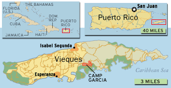 During
the 1940s, the US Navy acquired about 25,000 acres on the western
and eastern ends of Vieques, Puerto Rico,
an island located about seven miles southeast of mainland Puerto Rico. Vieques
was used for naval gunfire support and air-to-ground ordnance training from
the 1940's until May 1, 2003, when the Navy ceased all military operations
on the island and transferred its property on the eastern side of the island
to the Fish and Wildlife Service of the US Department of the Interior (DOI).
The land was designated as a wildlife refuge. About 8,100 acres of land
on the western side of the island, which had been used for the munitions
storage, was transferred to DOI, the municipality of Vieques and the Puerto
Rico Conservation Trust on May 1, 2001.
During
the 1940s, the US Navy acquired about 25,000 acres on the western
and eastern ends of Vieques, Puerto Rico,
an island located about seven miles southeast of mainland Puerto Rico. Vieques
was used for naval gunfire support and air-to-ground ordnance training from
the 1940's until May 1, 2003, when the Navy ceased all military operations
on the island and transferred its property on the eastern side of the island
to the Fish and Wildlife Service of the US Department of the Interior (DOI).
The land was designated as a wildlife refuge. About 8,100 acres of land
on the western side of the island, which had been used for the munitions
storage, was transferred to DOI, the municipality of Vieques and the Puerto
Rico Conservation Trust on May 1, 2001.
Various areas of the island may be contaminated by solid and/or hazardous waste resulting from decades of military activity including training exercises, equipment maintenance, supply storage and waste disposal. Working with EPA and the Puerto Rico Environmental Quality Board (EQB), the Navy will conduct an environmental investigation of its previously-owned property under the federal Resource Conservation and Recovery Act (RCRA) to determine what cleanup actions are needed. EPA has been providing technical assistance and guidance to the Navy on environmental issues related to the land transfer on the western site of Vieques.
For more information on this page, contact: barry.benjamin@epa.gov