U.S. Geological Survey
Fifth in a series of Congressional Briefings
| Friday, September 21, 2001 10:00 a.m. - 11:00 a.m. Rayburn House Office Building Room 2318 Washington, DC Refreshments will be served |
Speakers: (Speaker Biographies) Barbara Ryan U.S. Geological Survey Dr. Doyle Watts Wright State University This link leaves the USGS site. Dr. Mary Cleave Earth Science Enterprise, NASA This link leaves the USGS site. |
| Hosted by: The following links leave the USGS site. The American Society for Photogrammetry & Remote Sensing |
|
| Congressional Sponsors: The following links leave the USGS site. | |
| Representative Tom Davis (VA) | |
| Senator Tim Johnson (SD) | |
| Senator Tom Daschle (SD) | |
| Representative Sherwood Boehlert (NY) | |
| Representative Ralph Hall (TX) | |
| Representative John Thune (SD) | |
Those attending the briefing will receive a 4-CD-ROM set of Landsat satellite images of the 50 United States. The images were compiled by Earth Satellite Corporation from data acquired by Landsat 5. Included with the images is a tutorial of Landsat data and its applications.
Directions to Rayburn House Office Building:
East on Rt.66 over the Roosevelt Bridge; right on Independence Avenue. Follow Independence past the construction of the Botanic Gardens; right on Canal Street (2 blocks); left on D Street.
![]() Landsat Briefing Invitation - (PDF File 2637 KB)
Landsat Briefing Invitation - (PDF File 2637 KB)
 |
...I climb so high that the men and boats are lost in the black depths below and the dashing river is a rippling brook, and still there is more canyon above than below. All about me are intersting geologic records. John Wesley Powell |
Data from Landsat satellites have provided the United States and international users with a continuous stream of land-image data since 1972. The wealth of data now available -- with more continuing to arrive -- provides an unprecedented ability to look at changes on the Earth over nearly three decades. Learn how Federal, State and local governments and the private sector are using Landsat data to address issues related to agriculture, land-use planning, coastal resources, and the effects of natural disasters.
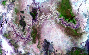 | Landsat 7 data acquired on May 12 and May 21, 2000 were used to produce a unique moderate resolution satellite mosaic of the Grand Canyon region. The data, which coer an area approximately 200 X 100 miles, offer a synoptic view of the landforms and drainage patterns of the region. These data are used to study land forms, land use, and geologic patterns and their relationships. The data were acquired and processed at the USGS´s EROS Data Center in Sioux Falls, SD. |
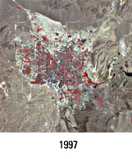
| Las Vegas, NV is one of the fastest-growing metropolitan areas in the U.S. These landsat images show the growth for the past 27 years. |  |
 |
 |
|
| For more information regarding the Landsat Program visit http://Landsat7.usgs.gov. | ||||
Everyone is welcome to attend this briefing. Presentations will illustrate how earth and biological science information from the U.S. Geological Survey (USGS) is helping decisionmakers effectively address societal, environmental, and economic needs.
Dr. Mary Cleave
Dr. Mary Cleave was appointed as Deputy Associate Administrator of NASA´s Office of Earth Science in February 2000. Her primary responsibility is developing plans and priorities for the Earth Science Enterprise´s advanced science, technology, and applications. For ESE, advanced planning has a lead time of at least two years.
Dr. Cleave came to NASA when she was selected to be an astronaut. She left Utah State University, where she was a research engineer to become a Mission Specialist at Johnson Space Center. Not only did she meet the necessary personal and physical standards for astronauts, but her background as an scientist and engineer further qualified her for space exploration. She flew aboard the Space Shuttle twice. She was a mission specialist flight engineer on STS 61-B in 1985. On her second flight, Dr. Cleave was mission specialist on STS-30, which deployed the Magellan Venus exploration spacecraft.
Since that time, she has continued to serve NASA in her specialty areas of ecology and environmental engineering, including work as Project Manager of SeaWifs. Before her appointment, Dr. Cleave was the Earth Science Representative to NASA´s Chief Scientist.
She was named NASA Engineer of the Year in 1998, received the NASA Exceptional Achievement Medal (1994), AAS Flight Achievement Award (1989), and NASA´s Exceptional Service Medal twice (1988 and 1990).
She participated in the SES Career Development Program (1999) and the Contemporary Executive Development Program at GWU (1995) and has been Fellow for Excellence in Government since 1997. Dr. Cleave is a member of Tri-Beta, Sigma Xi, Tau Beta Pi, and the Society of Professional Engineers.
Barbara Ryan
Barbara J. Ryan is the Associate Director for Geography at the U.S. Geological Survey (USGS). In this capacity, she has program and policy oversight responsibilities for the Nation´s largest civilian mapping organization. During her 27-year career with the USGS, she has worked in seven States and Washington, D.C. From 1989 to 1991, she served as Staff Assistant to the Assistant Secretary for Water and Science at the Department of the Interior. Before becoming Associate Director for Geography, she served as the agency´s Chief Information Officer. She holds a Bachelor´s degree in Geology from the State University of New York at Cortland, a Master´s degree in Geography from the University of Denver, and a Master´s degree in Civil Engineering from Stanford University. She resides, with her husband and son, in Oakton, Virginia.
Dr. Doyle Watts
Dr. Doyle R. Watts was born in Dayton, Ohio, and holds the BS in Physics, and MS in Geology from Ohio State University, and the Ph.D. in Geology from the University of Michigan. He conducted geophysical research on three expeditions to Antarctica sponsored by United States Antarctica Research Program between 1975 to 1980. Dr. Watts was a postdoctoral research fellow at the University of Leeds, in England from 1979 to 1983 conducting geophysical investigations throughout the Scottish Highlands. He held the position of Lecturer in Geophysics at Glasgow University in Scotland between 1983 to 1999. While at Glasgow he participated in the joint Royal Society-Academia Sinica geotraverse of the Tibetan Plateau. He worked on a seismic survey over the deepest borehole in the world in the Kola Peninsula of Russia. He collaborated with the British Geological Survey and various commercial Oil Companies. He was funded by the Royal Society of London to work with colleagues in the Ohio Department of Natural Resources on the Serpent Mound structure in Ohio. He joined the faculty at Wright State University, Dayton, Ohio, in 1999.

![]() U.S. Department of the Interior |
U.S. Geological Survey
U.S. Department of the Interior |
U.S. Geological Survey
URL: http://www.usgs.gov/solutions/landsat.html
Page Contact Information:
Ask USGS
Page Last Modified: 24-Jan-2006@09:12
