|
Click here to start a tour of the Mount St. Helens National Volcanic Monument. Click on any of the images to continue to the next page in the linked page series. Or, see a thumbnail gallery. Click here to see tours of other national parks. |
|
|
 |
This website contains images produced from stereo photo pairs that were manipulated into anaglyphs (3-D images). You will need red-and-cyan stereo viewing glasses to get the 3-D visual effects. |
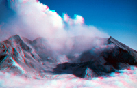 |
Aerial view of Mount St. Helens taken in 2005 after an eruption cycle. (All other images were taken in 2004 prior to the eruption.) |
| Click here to see the same images in standard photography. |
|
The National Forest Service website for Mount St. Helens National Volcanic Monument is: http://www.fs.fed.us/gpnf/mshnvm/ For geologic maps and information about Mount St. Helens National Monument check out these USGS websites: Mount St. Helens, Washington (USGS/Cascades
Volcano Observatory, Vancouver, Washington): DESCRIPTION: Mount St. Helens Volcano, Washington (USGS/Cascades Volcano Observatory, Vancouver, Washington): http://vulcan.wr.usgs.gov/Volcanoes/MSH/description_msh.html |
This website was prepared by Phil Stoffer
USGS Western Earth Surface Processes
Team, Menlo Park, California.
U.S.
Department of the Interior - U.S.
Geological Survey - Geology
Discipline |