Link to USGS home

Lake Mead National Recreation Area:

A 3D Photographic Geology Tour

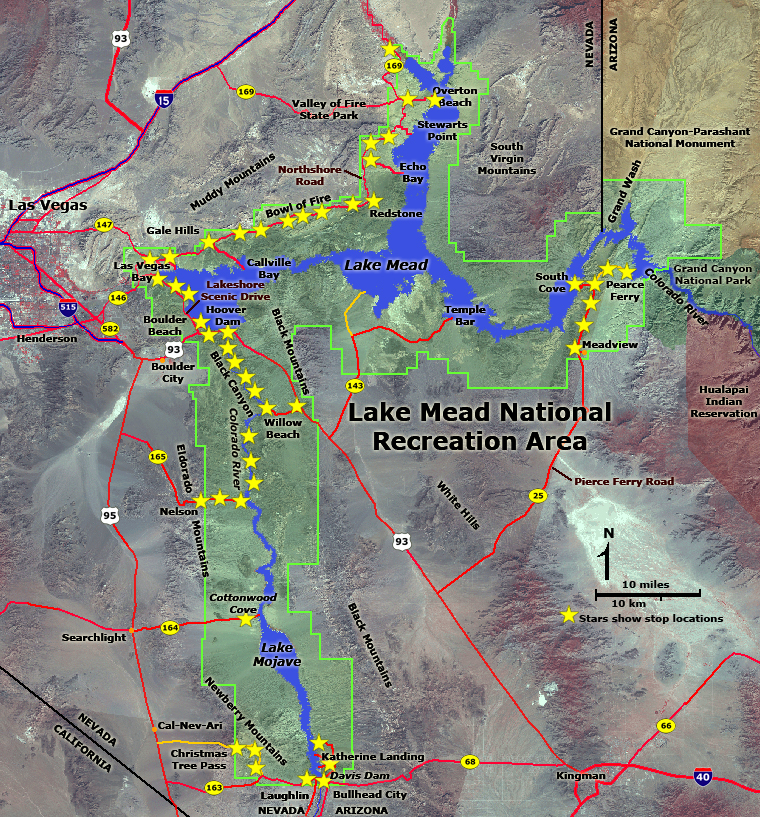
Click here to start a tour of Lake Mead National Recreation Area. Click on any of the images to continue to the next page in the linked page series. Or, see a thumbnail gallery.

Click here to see tours of other national parks.

Map of Lake Mead National Recreation Area
Click on the map or click on "next image" to see a series of park images. Click on "stars" to see localities.
(Also see this map without locations shown.)

next image

3D glasses

This website contains images produced from stereo photo pairs that were manipulated into anaglyphs (3D images). You will need red-and-cyan stereo viewing glasses to get the 3D visual effects.

Click here to see the same images in standard photography.

Click here to learn more about Lake Mead National Recreation Area (National Park Service website: http://www.nps.gov/lame).

Click here to see a generalized geologic map of Lake Mead National Recreation Area.

Click here for a detailed geologic map of the Lake Mead region (1:100,000 scale map).

Click here to see a summary of the geologic history of the Lake Mead National Recreation Area.

Click here for information about the stratigraphy of Lake Mead National Recreation Area.

Click here to see more 3D geology tours of National Parks.

This website was prepared by Phil Stoffer
USGS Western Earth Surface Processes Team, Menlo Park, California.

U.S. Department of the Interior - U.S. Geological Survey - Geology Discipline
Privacy statement -- General disclaimer -- Accessibility
This page is <http://3dparks.wr.usgs.gov/2005/lakemead/>
Maintained by Webmaster, Menlo Park, CA
Last modified 4/6/2007

www.usa.gov: Your first click to the U.S. Government
Hoover Dam Lakeview Overlook Boulder Beach Sunset Point 33 Hole Scenic Overlook Lava Butte view Las Vegas Wash Gypsum Wash Northshore Road near Callville Bay Gale Hills Gale Hills Callville Wash Bitter Springs Valley Redstone Echo Bay Road Muddy Mountains gorge Rogers Spring Stewarts Point Overton Badlands Overton Beach North Entrance Willow Beach Overlook Meadview Overlook Joshua Tree forest Pierce Ferry Road South Cove Road South Cove Pierce Ferry Road Pierce Ferry Davis Dam Katherine Landing Katherine Mine Tailings Davis Dam View Grapevine Canyon Newberry Mountains Christmas Tree Pass Cottonwood Cove Nelson Eldorado Canyon Lake Mohave Overlook Talus cones Bowl of Fire Overlook Black Canyon Black Canyon Black Canyon Black Canyon Willow Beach Black Canyon Black Canyon Black Canyon