
USGS/Cascades Volcano Observatory, Vancouver, Washington
DESCRIPTION:
"Ring of Fire", Plate Tectonics,
Sea-Floor Spreading, Subduction Zones,
"Hot Spots"
- "Ring of Fire"
- Plate Tectonics
- Earthquakes and Plate Tectonics
- Island-Arc, Oceanic, Continental Volcanoes
- Plate Tectonics and Volcanic Eruptions
- Cascade Range Volcanoes and Plate Tectonics
- East Africa Rift
- Hawaiian "Hot Spot"
- Iceland Volcanics and Plate Tectonics
- Juan De Fuca Ridge - Juan de Fuca Subduction
- Marianas Trench
- Mid-Atlantic Ridge
- South America, Plate Tectonics, and Volcanic Ranges
- Yellowstone "Hot Spot"
-
 [Map,27K,InlineGIF]
Map, Active Volcanoes, Plate Tectonics, and the "Ring of Fire"
-- Modified from: Tilling, Heliker, and Wright, 1987, and
Hamilton, 1976
From:
Brantley, 1994, Volcanoes of the United States: USGS General Interest
Publication
-
Volcanoes are not randomly distributed over the Earth's surface. Most are
concentrated on the edges of continents, along island chains, or beneath the sea
forming long mountain ranges. More than half of the world's active volcanoes
above sea level encircle the Pacific Ocean to form the circum-Pacific
"Ring of Fire."
In the past 25 years, scientists have developed a theory -- called
plate tectonics --
that explains the locations of volcanoes and their relationship to other
large-scale geologic features.
From:
Tilling, 1985, Volcanoes: USGS General Interest Publication
-
The peripheral areas of the Pacific Ocean Basin,
containing the boundaries of several plates are dotted by many active volcanoes
that form the so-called "Ring of Fire". The "Ring" provides excellent
examples of "plate-boundary" volcanoes, including
Mount St. Helens.
From:
Tilling, 1985, Volcanoes: USGS General Interest Publication
-
According to the new, generally accepted "plate-tectonics" theory,
scientists believe that the Earth's surface is broken into a number of
shifting slabs or plates,
which average about 50 miles in thickness. These plates move
relative to one another above a hotter, deeper, more mobile zone at average
rates as great as a few inches per year. Most of the world's active volcanoes
are located along or near the boundaries between shifting plates and are called
"plate-boundary" volcanoes.
However, some active volcanoes are not
associated with plate boundaries, and many of these so-called
"intra-plate" volcanoes form roughly linear chains in the interior of
some oceanic plates. The Hawaiian Islands
provide perhaps the best example of
an "intra-plate" volcanic chain, developed by the northwest-moving
Pacific Plate
passing over an inferred "hot spot" that initiates the magma-generation
and volcano-formation process. The peripheral areas of the Pacific Ocean Basin,
containing the boundaries of several plates are dotted by many active volcanoes
that form the so-called "Ring of Fire". The "Ring" provides excellent
examples of "plate-boundary" volcanoes, including
Mount St. Helens.
...
-
In the Pacific Northwest, the
Juan de Fuca Plate
plunges beneath the North American Plate,
locally melting at depth; the magma rises to feed and form the
Cascade volcanoes.
From:
Brantley, 1994, Volcanoes of the United States: USGS General Interest
Publication
-
Volcanoes are not randomly distributed over the Earth's surface. Most are
concentrated on the edges of continents, along island chains, or beneath the sea
forming long mountain ranges. More than half of the world's active volcanoes
above sea level encircle the Pacific Ocean to form the circum-Pacific
"Ring of Fire."
In the past 25 years, scientists have developed a theory -- called
plate tectonics --
that explains the locations of volcanoes and their relationship to other
large-scale geologic features.
-
According to this theory, the Earth's surface is made up of a patchwork of about
a dozen large plates that move relative to one another at speeds from less than
one centimeter to about ten centimeters per year (about the speed at which
fingernails grow). These rigid plates, whose average thickness is about 80
kilometers, are spreading apart, sliding past each other, or colliding with each
other in slow motion on top of the Earth's hot, pliable interior. Volcanoes
tend to form where plates collide or spread apart, but they can also grow in the
middle of a plate, as for example the
Hawaiian volcanoes.
-
The boundary between the Pacific and
Juan de Fuca Plates is marked by a broad
submarine mountain chain
about 500 kilometers long, known as the
Juan de Fuca Ridge.
Young volcanoes, lava flows, and hot springs were discovered in a broad
valley less than 8 kilometers wide along the crest of the ridge in the 1970's.
The ocean floor is spreading apart and forming new ocean crust along this valley
or "rift" as hot magma from the Earth's interior is injected into the ridge and
erupted at its top.
-
In the Pacific Northwest, the Juan de Fuca Plate plunges beneath the
North American Plate.
As the denser plate of oceanic crust if forced deep into the
Earth's interior beneath the continental plate, a process known as
subduction,
it encounters high temperatures and pressures that partially
melt solid rock. Some of this newly formed magma rises toward the Earth's
surface to erupt, forming a
chain of volcanoes
above the subduction zone.
-
Located in the middle of the Pacific Plate,
the volcanoes of the
Hawaiian Island chain
are among the largest on Earth. The volcanoes stretch 2,500 kilometers
across the north Pacific Ocean and become progressively older to the northwest.
Formed initially above a relatively stationary "hot spot" in the Earth's
interior, each volcano was rafted away from the hot spot as the
Pacific Plate
moves northwestward at about 9 centimeters per year. The island of Hawaii
consists of the youngest volcanoes in the chain and is currently located over
the hot spot.
From:
Tilling, Heliker, and Wright, 1987,
Eruptions of Hawaiian Volcanoes: Past, Present, and Future:
Department of the Interior/U.S. Geological Survey Publication
-
In the early 1960's, the related concepts of
"sea-floor spreading" and
"plate tectonics"
emerged as powerful new hypotheses that geologists used to interpret
the features and movements of the Earth's surface layer. According to the
plate tectonics theory, the Earth's surface consists of about a dozen
rigid slabs or plates, each averaging at least 50 miles thick. These
plates move relative to one another at average speeds of a few inches per year
-- about as fast as human fingernails grow. Scientists recognize three common
types of boundaries between these moving plates:
- Divergent or spreading -- adjacent plates pull apart, such as
at the
Mid-Atlantic Ridge, which separates the
North and South American Plates from the
Eurasian and African Plates.
This pulling apart causes
"sea-floor spreading" as new material is added to the oceanic plates.
- Convergent -- plates moving in opposite directions meet and one is
dragged down (or subducted) beneath the other.
Convergent plate boundaries
are also called subduction zones and are typified by the
Aleutian Trench, where the Pacific Plate
is being subducted under the North American Plate.
- Transform fault -- one plate slides horizontally past another. The
best known example is the earthquake-prone
San Andreas fault zone of California,
which marks the boundary between the Pacific and North American Plates.
From:
Hamilton, 1976, Plate Tectonics and Man:
Reprint from: USGS Annual Report, Fiscal Year 1976
-
The Earth's crust is broken into moving plates of "lithosphere". ...
There are seven very large plates, each consisting of both oceanic and
continental portions, and a dozen or more small plates. ... Each plate is about
80 kilometers (50 miles) thick and can be pictured as having a shallow part that
deforms by elastic bending or by brittle breaking, and a deeper part that yields
plastically, beneath which is a viscous layer on which the entire plate slides.
The plates tend to be internally rigid, and they interact mostly at their edges.
...
-
All plates are moving relative to all others. There are grounds for suggesting
that the African plate may now be approximately fixed relative to the deep
mantle, but if so it is the only such plate. Velocities of relative motion
between adjacent plates range from less than 1 centimeter (a small fraction of
an inch) to about 13 centimeters (5 inches) per year. Although these velocities
are slow by human standards, they are extremely rapid by geologic ones: a motion
of 5 centimeters (2 inches) per year, for example, adds up to 50 kilometers (30
miles) in only 1 million years, and some plate motions have been continuous for
100 million years.
-
Plates are now pulling apart primarily along the system of great submarine
ridges in the world's oceans. Hot material from the deeper mantle wells up
into the gap, and some of it melts and is erupted on the surface as lava or is
injected near the surface to crystallize as other igneous rocks. The ridge
stands high because its material is hot, and hence low in density. As the
plates move apart, the ridge material gradually cools and contracts, and its
surface sinks. Ridges generally form step-like alternations of spreading
centers perpendicular to the direction of motion and of strike-slip faults
parallel to that direction. ...
-
Where plates converge, one tips down and slides beneath the other. Generally,
an oceanic plate slides ("subducts") beneath a continental plate (for example,
along the west coast of
South America)
or another oceanic plate (for example,
the east side of the Philippine Sea plate). A trench is formed where the
under-sliding plate tips down, and the ocean-floor sediment it carries is
scraped off against the front of the overriding plate. ... We know much
about the mechanics of these junctions from geophysical studies and particularly
from seismic-reflection profiles made across them with instruments developed for
oil-field exploration. Farther back under the overriding plate, zones of
earthquakes, inclined down into the mantle to depths that reach 700 kilometers
(450 miles), show the trajectory of the descending plate. Typically, a belt of
volcanoes lies above the part of this inclined earthquake zone, which is about
125 kilometers (80 miles) deep. ...
-
New oceanic-plate (lithosphere) material is generated by the upwelling processes
at spreading ridges. Old lithosphere is consumed, and recycled deep into the
mantle, at the same rate as the convergent trenches. The balance is global
only: the formation of lithosphere at the Mid-Atlantic Ridge
is compensated by subduction primarily in the western Pacific.
-
Plates slide past one another along strike-slip faults, which can be either on
land or at sea. The best known of these faults is the San Andreas Fault of
California. ...
-
... Plate motions have dominated tectonic and magmatic processes for the past
2,500 million years. ...
-
... If present major plate motions
continue for another 50 million years, Australia will be crowded against China,
and the island complexes of Indonesia and the Philippines will be squashed into
a mountain system between the colliding continents. ...
-
Most volcanoes are products of lithosphere-plate motions. The
"ring of fire" around the Pacific represents one type of this volcanism.
The chains of volcanoes in the island arcs (such as the
Aleutian Islands)
and continental margins (such as the
Andes)
around much of the ocean form
above undersliding oceanic plates. The main volcanic axis is typically about
125 kilometers (80 miles) above the inclined zone of earthquakes that marks the
descent of the lithosphere plate into the deep mantle ...
so processes related to the descent and to that depth must control the melting
of the magmas. The melts that arrive at the surface, to erupt in volcanoes,
have been profoundly modified by reactions with the mantle and crustal rocks
through which they have risen. Lavas formed in this setting have distinctive
compositions and systematic variations that relate directly to their height
above the subducting plate. These characteristics permit us to recognize rocks
formed in similar settings in the geologic past and to estimate the depths to
the long-dead seismic zones above which they formed. Where, in ancient
terrains, the volcanic rocks have been eroded away, we now see granites and
other rocks which crystallized slowly within the crust from similar magmas.
-
The high volcanoes of the
Cascade Range
in Oregon and Washington --
Mount Hood
and
Mount Rainier,
for example -- form a short chain of
this type, vigorously active until not many thousand years ago but now showing
only infrequent activity. The decline in volcanism reflects a plate-boundary
change now underway to the west: there was until recently rapid subduction of a
small Pacific plate beneath northern California, Oregon, and Washington, but the
pattern is presently changing; the San Andreas Fault system is now breaking
across the small plate. ...
|
Earthquakes and Plate Tectonics
|
-
 [Map30K,InlineGIF]
Earthquakes, Active Volcanoes, and Plate Tectonics
-- Earthquakes around the world as compared to plate boundaries of
the "Ring of Fire"
-- Topinka, USGS/CVO, 1999
From:
Noson, Qamar, and Thorsen, 1988,
Washington State Earthquake Hazards:
Washington State Department of Natural Resources,
Washington Division of Geology and Earth Resources Information Circular 85
-
Earth scientists believe that most
earthquakes
are caused by slow movements
inside the Earth that push against the Earth's brittle, relatively thin outer
layer, causing the rocks to break suddenly. This outer layer is fragmented into
a number of pieces, called plates.
Most earthquakes occur at the boundaries of these plates. In Washington State,
the small
Juan de Fuca plate
off the coast of Washington, Oregon, and northern
California is slowly moving eastward beneath a much larger plate that includes
both the North American continent the land beneath part of the Atlantic Ocean.
Plate motions in the Pacific Northwest result in shallow earthquakes widely
distributed over Washington and deep earthquakes in the western parts of
Washington and Oregon. The movement of the
Juan de Fuca plate beneath the
North America plate
is in many respects similar to the movements of plates in South
America, Mexico, Japan, and Alaska, where the world's largest earthquakes occur.
...
-
The plate tectonics theory is a starting point for understanding the
forces within the Earth that cause earthquakes. Plates are thick slabs
of rock that make up the outermost 100 kilometers or so of the Earth.
Geologists use the term "tectonics" to describe deformation of the Earth's
crust, the forces producing such deformation, and the geologic and structural
features that result.
-
Earthquakes
occur only in the outer, brittle portions of these plates, where
temperatures in the rock are relatively low. Deep in the Earth's interior,
convection of the rocks, caused by temperature variations in the Earth, induces
stresses that result in movement of the overlying plates. The rates of plate
movements range from about 2 to 12 centimeters per year and can now be measured
by precise surveying techniques. The stresses from convection can also deform
the brittle portions of overlying plates, thereby storing tremendous energy
within the plates. If the accumulating stress exceeds the strength of the rocks
comprising these brittle zones, the rocks can break suddenly, releasing the
stored elastic energy as an earthquake.
-
Three major types of plate boundaries are recognized. These are called
spreading, convergent, or transform, depending on whether
the plates move away from, toward, or laterally past one another, respectively.
Subduction occurs where one plate converges toward another plate, moves beneath
it, and plunges as much as several hundred kilometers into the Earth's interior.
The
Juan de Fuca plate
off the coasts of Washington and Oregon is subducting beneath North America.
-
Ninety percent of the world's earthquakes occur along plate boundaries where the
rocks are usually weaker and yield more readily to stress than do the rocks
within a plate. The remaining 10 percent occur in areas away from present plate
boundaries -- like the great New Madrid, Missouri, earthquakes of 1811 and 1812,
felt over at least 3.2 million square kilometers, which occurred in a region of
southeast Missouri that continues to show seismic activity today.
-
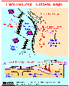
The Cascadia subduction zone off the coast of Washington, Oregon, and northern
California is a convergent boundary
between the large North America plate and the small Juan de Fuca plate to the
west. The Juan de Fuca plate moves northeastward and then plunges (subducts)
obliquely beneath the North America plate at a rate of 3 to 4 centimeters per
year. ...
In sum, the subduction of the Juan de Fuca plate beneath the North America plate
is believed to directly or indirectly cause most of the earthquakes and young
geologic features in Washington and Oregon.
-
 Earthquakes and Seismicity Menu
|
Island-Arc, Oceanic, Continental Volcanics
|
From:
Tilling, 1985, Volcanoes:
USGS General Interest Publication
-
There are more than 500 active volcanoes (those that have erupted at least once within recorded history) in the world -- 50 of
which are in the United States (Hawaii, Alaska, Washington, Oregon, and California) -- although many more may be hidden under the
seas. Most active volcanoes are strung like beads along, or near, the margins of the continents, and more than half encircle the
Pacific Ocean as a "Ring of Fire". ...
-
Some volcanoes crown island areas lying near the continents, and others form chains of islands in the deep ocean
basins. Volcanoes tend to cluster along narrow mountainous belts where folding and fracturing of the rocks
provide channelways to the surface for the escape of the magma. Significantly, major earthquakes also occur
along these belts, indicating that volcanism and seismic activity are often closely related, responding to the
same dynamic Earth forces.
-
Island-Arc Volcanics:
-
In a typical "island-arc" environment, volcanoes lie along the crest of an arcuate,
crustal ridge bounded on its convex side by a deep oceanic trench. The granite or granitelike
layer of the continental crust extends beneath the ridge to the vicinity of the trench.
Basaltic magmas, generated in the mantle beneath the ridge, rise along fractures through the
granitic layer. These magmas commonly will be modified or changed in composition during
passage through the granitic layer and erupt on the surface to form volcanoes built largely of
nonbasaltic rocks.
-
 Island-Arc Volcanics
-- [Graphic,30K,GIF]
Island-Arc Volcanics
-- [Graphic,30K,GIF]
-
Oceanic Volcanics:
-
In a typical "oceanic" environment, volcanoes are alined along the crest of a broad ridge that
marks an active fracture system in the oceanic crust. Basaltic magmas, generated in the upper
mantle beneath the ridge, rise along fractures through the basaltic layer. Because the
granitic crustal layer is absent, the magmas are not appreciably modified or changed in
composition and they erupt on the surface to form basaltic volcanoes.
-
 Oceanic Volcanics
-- [Graphic,26K,GIF]
Oceanic Volcanics
-- [Graphic,26K,GIF]
-
Continental Volcanics:
-
In the typical "continental" environment, volcanoes are located in unstable,
mountainous belts that have thick roots of granite or granitelike rock. Magmas, generated
near the base of the mountain root, rise slowly or intermittently along fractures in the
crust. During passage through the granite layer, magmas are commonly modified or changed in
composition and erupt on the surface to form volcanoes constructed of nonbasaltic rocks.
-
 Continental Volcanics
-- [Graphic,33K,GIF]
Continental Volcanics
-- [Graphic,33K,GIF]
From:
Wood and Kienle, 1990, Volcanoes of North America:
Cambridge University Press, contribution by J. Kienle and C.J. Nye
-
Most Alaskan volcanoes
are in the Aleutian arc which extends approximately 2,500 kilometers along
the southern edge of the Bering Sea and Alaskan mainland. This classic volcanic arc
contains some 80 Quaternary
stratovolcanoes and
calderas.
Aleutian arc volcanism is the result of subduction of the Pacific Plate
beneath the North American Plate. The 3,400-kilometer-long Aleutian trench that extends
from the northern end of the Kamchatka trench to the Gulf of Alaska marks the boundary
between the two plates.
From:
Smithsonian Institution's Global Volcanism Program's Website,
May 2000
-
The great sweep of the Sunda Arc, over 3,000 kilometers from
NorthWest Sumatra
to the Banda Sea, results from the subduction of the Indian Ocean crust
beneath the Asian Plate. This arc includes 76 percent of the region's
volcanoes, but those on either end are tectonically more complex. ...
From:
Brantley, 1994, Volcanoes of the United States: USGS General Interest
Publication
-
In the Pacific Northwest, the
Juan de Fuca Plate plunges beneath the North American Plate.
As the denser plate of oceanic crust is forced deep into the
Earth's interior beneath the continental plate, a process known as
subduction, it encounters high temperatures and pressures that partially
melt solid rock. Some of this newly formed magma rises toward the Earth's
surface to erupt, forming a
chain of volcanoes (the Cascade Range) above the subduction zone.
|
Plate Tectonics and Volcanic Eruptions
|
From:
Kious and Tilling, 1996,
This Dynamic Earth: The Story of Plate Tectonics:
USGS Special Interest Publication
-
As with earthquakes, volcanic activity is linked to plate-tectonic processes.
Most of the world's active above-sea
volcanoes are located near convergent plate boundaries where subduction is occurring,
particularly around the Pacific
basin. However, much more volcanism -- producing about three quarters of all lava
erupted on Earth -- takes place
unseen beneath the ocean, mostly along the oceanic spreading centers,
such as the Mid-Atlantic Ridge and the East
Pacific Rise.
-
Subduction-zone volcanoes like
Mount St. Helens
(in Washington State) and
Mount Pinatubo
(Luzon, Philippines), are called
composite cones
and typically erupt with explosive force, because the magma is too stiff to
allow easy escape of
volcanic gases. As a consequence, tremendous internal pressures mount as the
trapped gases expand during ascent,
before the pent-up pressure is suddenly released in a violent eruption.
Such an explosive process can be compared to
putting your thumb over an opened bottle of a carbonated drink,
shaking it vigorously, and then quickly removing the
thumb. The shaking action separates the gases from the liquid to form bubbles,
increasing the internal pressure. Quick
release of the thumb allows the gases and liquid to gush out
with explosive speed and force.
-
In 1991, two volcanoes on the western edge of the
Philippine Plate produced major eruptions. On June 15,
Mount Pinatubo
spewed ash 40 km into the air and produced huge ash flows (also called pyroclastic flows)
and mudflows that
devastated a large area around the volcano.
Pinatubo, located 90 km from Manila, had been dormant for 600 years
before the 1991 eruption, which ranks as one of the largest eruptions in this century.
Also in 1991, Japan's Unzen Volcano,
located on the Island of Kyushu about 40 km east of Nagasaki,
awakened from its 200-year slumber to
produce a new lava dome at its summit. Beginning in June,
repeated collapses of this active dome generated destructive
ash flows that swept down its slopes at speeds as high as 200 km per hour.
Unzen is one of more than 75 active
volcanoes in Japan; its eruption in 1792 killed more than
15,000 people--the worst volcanic disaster in the country's
history.
-
While the Unzen eruptions have caused deaths and considerable local damage,
the impact of the June 1991 eruption of
Mount Pinatubo was global. Slightly cooler than usual temperatures
recorded worldwide and the brilliant sunsets and
sunrises have been attributed to this eruption that sent fine ash and
gases high into the stratosphere, forming a large
volcanic cloud that drifted around the world. The sulfur dioxide (SO2)
in this cloud -- about 22 million tons -- combined
with water to form droplets of sulfuric acid, blocking some of the
sunlight from reaching the Earth and thereby cooling
temperatures in some regions by as much as 0.5 °C. An eruption the
size of Mount Pinatubo could affect the weather for
a few years. A similar phenomenon occurred in April of 1815
with the cataclysmic eruption of Tambora Volcano in
Indonesia, the most powerful eruption in recorded history.
Tambora's volcanic cloud lowered global temperatures by as
much as 3 °C. Even a year after the eruption, most of the
northern hemisphere experienced sharply cooler temperatures
during the summer months. In part of Europe and in North America,
1816 was known as "the year without a summer."
-
Apart from possibly affecting climate, volcanic clouds from explosive eruptions
also pose a hazard to aviation safety.
During the past two decades, more than 60 airplanes, mostly commercial jetliners,
have been damaged by in-flight
encounters with volcanic ash. Some of these encounters have resulted in the power
loss of all engines, necessitating
emergency landings. Luckily, to date no crashes have happened be-cause of
jet aircraft flying into volcanic ash.
-
Since the year A.D. 1600, nearly 300,000 people have been killed by volcanic eruptions.
Most deaths were caused by
pyroclastic flows and mudflows, deadly hazards which often accompany explosive
eruptions of subduction-zone
volcanoes. Pyroclastic flows, also called nuées ardentes ("glowing clouds" in French),
are fast-moving, avalanche-like,
ground-hugging incandescent mixtures of hot volcanic debris, ash, and gases that
can travel at speeds in excess of 150 kilometers
per hour. Approximately 30,000 people were killed by
pyroclastic flows
during the
1902 eruption of Mont Pelee
on the
Island of Martinique in the Caribbean. In March-April 1982,
three explosive eruptions of El Chichón Volcano in the State
of Chiapas, southeastern Mexico, caused the worst volcanic disaster in that
country's history. Villages within 8 km of the
volcano were destroyed by pyroclastic flows, killing more than 2,000 people.
-
Mudflows
(also called debris flows or lahars, an Indonesian term for volcanic mudflows)
are mixtures of volcanic debris
and water. The water usually comes from two sources:
rainfall or the melting of snow and ice by hot volcanic debris.
Depending on the proportion of water to volcanic material,
mudflows can range from soupy floods to thick flows that
have the consistency of wet cement.
As mudflows sweep down the steep sides of composite volcanoes, they have the
strength and speed to flatten or bury everything in their paths.
Hot ash and pyroclastic flows from the eruption of the
Nevado del Ruiz Volcano
in Colombia, South America,
melted snow and ice atop the 5,390-m-high Andean peak; the
ensuing mudflows buried the city of Armero, killing 25,000 people.
-
Eruptions of Hawaiian
and most other mid-plate volcanoes
differ greatly from those of composite cones.
Mauna Loa and Kilauea, on the island of Hawaii, are known as
shield volcanoes,
because they resemble the wide, rounded shape of an
ancient warrior's shield. Shield volcanoes tend to erupt non-explosively,
mainly pouring out huge volumes of fluid lava.
Hawaiian-type eruptions are rarely life threatening because the lava advances
slowly enough to allow safe evacuation of
people, but large lava flows can cause considerable economic loss by destroying
property and agricultural lands. For
example, lava from the ongoing eruption of Kilauea, which began in
January 1983, has destroyed more than 200
structures, buried kilometers of highways, and disrupted the daily
lives of local residents. Because Hawaiian volcanoes
erupt frequently and pose little danger to humans, they provide an
ideal natural laboratory to safely study volcanic
phenomena at close range. The
USGS Hawaiian Volcano Observatory,
on the rim of Kilauea, was among the world's
first modern volcano observatories, established early in this century.
-
In recorded history, explosive eruptions at subduction-zone (convergent-boundary)
volcanoes have posed the greatest
hazard to civilizations. Yet scientists have estimated that about
three quarters of the material erupted on Earth each year
originates at spreading mid-ocean ridges. However, no deep
submarine eruption has yet been observed "live" by
scientists. Because the great water depths preclude easy observation,
few detailed studies have been made of the
numerous possible eruption sites along the tremendous length (50,000 km)
of the global mid-oceanic ridge system.
Recently however, repeated surveys of specific sites along the
Juan de Fuca Ridge,
off the coast of the Oregon and
Washington, have mapped deposits of fresh lava, which must have been
erupted sometime between the surveys. In June
1993, seismic signals typically associated with submarine eruptions --
called T-phases -- were detected along part of the
spreading Juan de Fuca Ridge and interpreted as being caused by eruptive activity.
-
Iceland, where the Mid-Atlantic Ridge is exposed on land, is a different story.
It is easy to see many
Icelandic volcanoes
erupt non-explosively from fissure vents,
in similar fashion to typical Hawaiian eruptions; others, like
Hekla Volcano,
erupt explosively. (After Hekla's catastrophic eruption in 1104,
it was thought in the Christian world to be the "Mouth to Hell.")
The voluminous, but mostly non-explosive, eruption at Lakagígar (Laki), Iceland,
in 1783, resulted in one of the world's
worst volcanic disasters. About 9,000 people --
almost 20 percent of the country's population at the time -- died of starvation
after the eruption, because their livestock had perished from grazing on
grass contaminated by fluorine-rich gases emitted
during this eight month-long eruption.
|
Cascade Range Volcanoes and Plate Tectonics
|
-
 [Graphic,20K,InlineGIF]
Graphic, Plate Tectonics and the Cascade Range
-- Modified from: Tilling, 1985
-
 [Graphic,20K,InlineGIF]
Graphic, Juan de Fuca Subduction - Juan de Fuca Ridge - Cascade Range
-- Modified from: Brantley, 1994
From:
Swanson, et.al., 1989,
Cenozoic Volcanism in the Cascade Range and Columbia Plateau,
Southern Washington and Northernmost Oregon:
AGU Field Trip Guidebook T106.
-
The
Cascade Range
has been an active arc for about 36 million years as a
result of plate convergence.
Volcanic rocks between 55 and 42 million years ago occur in the Cascades, but
are probably related to a rather diffuse volcanic episode that created the
Challis arc extending southeastward from northern to northwest Wyoming.
Convergence between the North American and
Juan de Fuca plates
continues at
about 4 centimeters per year in the direction of North-50-degrees-East, a
slowing of 2-3 centimeters per year since 7 million years ago. According to
most interpretations, volcanism in the Cascades has been discontinuous in time
and space, with the most recent episode of activity beginning about 5 million
years ago and resulting in more than 3000 vents.
-
In Oregon, the young terrane is commonly called the
High Cascades
and the old terrane the Western Cascades,
terms that reflect present physiography and geography.
The terms are not useful in Washington, where young
vents are scattered across the dominantly middle Miocene and older terrane. ...
-
In Washington and Oregon, a striking contrast has existed for the past 5 million
years in the style of volcanism in the Cascades relative to geography. North of
Mount Rainier,
young volcanism is concentrated in only a few isolated andesitic and dacitic
composite cones
(notably
Glacier Peak,
Mount Baker, and the volcanoes of the
Garibaldi belt in British Columbia),
whereas south of
Mount Hood
moderate-sized andesitic and dacitic composite cones are
relatively unimportant features of a landscape dominated by small andesite and
basalt vents. The area between
Mounts Rainier and Hood
is transitional; large
andesite and dacite composite cones
(
Rainier,
Adams,
St. Helens,
Hood,
and the extinct
Goat Rocks volcano)
occur together with fields and scattered vents of olivine basalt
(
Indian Heaven,
Simcoe Mountains,
and the
King Mountain fissure zone south of Mount Adams. ...
-
The southern Washington Cascades are seismically active.
Most earthquakes occur
along the 100-kilometer-long, north-northwest trending St. Helens seismic zone,
where most focal mechanisms show dextral slip parallel to the trend of the zone
and consistent with the direction of plate convergence. Other crustal
earthquakes concentrate just west of Mount Rainier and in the Portland
(Oregon) area. Few earthquakes occur north of
Mount Rainier or south of Mount Hood.
-
From tomography, Rasmussen and Humphreys (1988) interpret the subducted
Juan de Fuca plate
as a quasi-planar feature dipping about 65 degrees to about 300 kilometers under
the
southern Washington Cascades.
The plate is poorly defined seismically,
however, owing to a lack of earthquakes within it. Guffanti and Weaver
(1988) show that the present volcanic front of the
Washington Cascades, defined
by the westernmost young vents, parallels the curved trend of the subducting
plate reflected by the 60 kilometer-depth contour. The front trends northwest in
northern Washington -- where
Glacier Peak,
Mount Baker,
and the volcanoes of
southern British Columbia
occur along a virtually straight line --
and northeast in southern Washington. A 90-kilometer gap free of young
volcanoes between
Mount Rainier
and Glacier Peak is landward of
that part of the subducting plate with the least average dip to a depth of 60
kilometers. South of Portland, the volcanic front is offset 50 kilometers
eastward and extends southward into California, probably still parallel to the
trend of the convergent margin.
-
Cascade Range Menu
From:
Kious and Tilling, 1996,
This Dynamic Earth: The Story of Plate
Tectonics: USGS Online version 1.08
-
In East Africa, spreading processes have already torn
Saudi Arabia away from the rest of the African
continent, forming the Red Sea.
The actively splitting
African Plate and the Arabian Plate
meet in what
geologists call a triple junction, where the Red Sea
meets the Gulf of Aden. A new spreading center
may be developing under Africa along the East African Rift Zone.
When the continental crust stretches
beyond its limits, tension cracks begin to appear on the
Earth's surface. Magma rises and squeezes
through the widening cracks, sometimes to erupt and form
volcanoes. The rising magma, whether or not
it erupts, puts more pressure on the crust to produce
additional fractures and, ultimately, the rift zone.
-
East Africa may be the site of the Earth's next
major ocean. Plate interactions in the region provide
scientists an opportunity to study first hand how
the Atlantic may have begun to form about 200 million
years ago. Geologists believe that, if spreading
continues, the three plates that meet at the edge of the
present-day African continent will separate completely,
allowing the Indian Ocean to flood the area and
making the easternmost corner of Africa
(the Horn of Africa) a large island.
-
Africa Volcanoes Menu
From:
Tilling, Heliker, and Wright, 1987,
Eruptions of Hawaiian Volcanoes: Past, Present, and Future:
Department of the Interior/U.S. Geological Survey Publication
-
The great majority of the world's earthquakes and active volcanoes occur near
the boundaries of the Earth's shifting plates. Why then are the
Hawaiian volcanoes
located near the middle of the Pacific Plate, more than 2,000 miles
from the nearest plate boundary? In 1963, J. Tuzo Wilson, a Canadian
geophysicist, provided an ingenious explanation within the framework of plate
tectonics by proposing the "Hot Spot" hypothesis. Wilson's hypothesis
has come to be accepted widely, because it agrees well with much of the
scientific data on the Pacific Ocean in general, and the Hawaiian Islands in
particular.
-
According to Wilson, the distinctive linear shape of the
Hawaiian-Emperor Chain
reflects the progressive movement of the Pacific Plate
over a deep immobile
hot spot. This hot spot partly melts the region just below the
overriding Pacific Plate,
producing small, isolated blobs of magma. Less dense
than the surrounding solid rock, the magma rises buoyantly through structurally
weak zones and ultimately erupts as lava onto the ocean floor to form volcanoes.
-
Over a span of about 70 million years, the combined processes of magma
formation, eruption, and continuous movement of the
Pacific Plate over
the stationary hot spot have left the trail of volcanoes across the ocean
floor that we now call the Hawaiian-Emperor Chain.
Scientists interpret
the sharp bend in the chain, about 2,200 miles northwest of the Big Island, as
indicating a change in the direction of plate motion that occurred about 43
million years ago, as suggested by the ages of the volcanoes bracketing the bend.
-
Part of the Big Island, the southeasternmost and youngest island, presently
overlies the hot spot and still taps the magma source to feed its two currently
active volcanoes, Kilauea
and Mauna Loa. The active submarine volcano, Loihi,
off the Big Island's south coast, may mark the beginning
of the zone of magma formation at the southeastern edge of the hot spot. The
other Hawaiian islands have moved northwestward beyond the hot spot, were
successively cut off from the sustaining magma source, and are no longer
volcanically active.
-
The progressive northwesterly drift of the islands from their point of origin
over the hot spot is well shown by the ages of the principal lava flows on the
various Hawaiian Islands from northwest (oldest) to southeast (youngest), given
in millions of years: Kauai, 5.6 to 3.8; Oahu, 3.4 to 2.2;
Molokai, 1.8 to 1.3; Maui, 1.3 to 0.8; and Hawaii, less
than 0.7 and still growing.
-
Even on the Big Island alone, the relative ages of its five volcanoes are
compatible with the hot-spot theory. Kohala, at the northwestern corner
of the island, is the oldest, having ceased eruptive activity about 60,000 years
ago. The second oldest is Mauna Kea, which last erupted about 3,000
years ago; next is Hualalai, which has had only one historic eruption
(1800-1801), and lastly, both Mauna Loa and Kilauea have been
vigorously and repeatedly active in historic times. Because it is growing on
the southeastern flank of Mauna Loa, Kilauea is believed to be younger than its
huge neighbor.
-
The size of the Hawaiian hot spot is not know precisely, but it
presumably is large enough to encompass the currently active volcanoes of
Mauna Loa, Kilauea, Loihi, and, possibly, also
Hualalai and Haleakala. Some scientists have estimated the
Hawaiian hot spot to be about 200 miles across, with much narrower vertical
passageways that feed magma to the individual volcanoes.
From:
Kious and Tilling,
This Dynamic Earth: The Story of Plate Tectonics:
USGS Online Publication
-
In 1963, J. Tuzo Wilson, the Canadian geophysicist who discovered transform faults,
came up with an ingenious idea that
became known as the "hotspot" theory.
Wilson noted that in certain locations around the world,
such as Hawaii, volcanism has
been active for very long periods of time. This could only happen, he reasoned,
if relatively small, long-lasting, and exceptionally
hot regions -- called hotspots -- existed below the plates that would provide localized
sources of high heat energy (thermal
plumes) to sustain volcanism.
-
Specifically, Wilson hypothesized that
the distinctive
linear shape of the Hawaiian Island-Emperor
Seamounts chain resulted from the Pacific Plate moving over a deep, stationary hotspot
in the mantle,
located beneath the
present-day position of the Island of Hawaii.
Heat from this hotspot produced a persistent
source of magma by partly melting the
overriding Pacific Plate. The magma, which is lighter than the surrounding solid rock,
then rises through the mantle and crust to
erupt onto the seafloor, forming an active seamount.
Over time, countless eruptions cause
the seamount to grow until it finally
emerges above sea level to form an island volcano. Wilson suggested that continuing plate
movement eventually carries the island
beyond the hotspot, cutting it off from the magma source, and volcanism ceases.
As one island volcano becomes extinct, another
develops over the hotspot, and the cycle is repeated. This process of volcano growth and
death, over many millions of years,
has left a long trail of volcanic islands and seamounts across the Pacific Ocean floor.
-
According to Wilson's hotspot theory,
the volcanoes of the Hawaiian chain should get
progressively older and become more
eroded the farther they travel beyond the hotspot.
The oldest volcanic rocks on Kauai,
the northwesternmost inhabited Hawaiian
island, are about 5.5 million years old and are deeply eroded.
By comparison, on the "Big Island" of Hawaii --
southeasternmost
in the chain and presumably still positioned over the hotspot --
the oldest exposed rocks are less than
0.7 million years old and
new volcanic rock is continually being formed.
-
 Link to: Hawaiian Volcano Observatory (HVO) for MORE Information
|
Iceland Volcanics and Plate Tectonics
|
From:
Newhall and Dzurisin, 1988,
Historical Unrest at Large Calderas of the World:
U.S. Geological Survey Bulletin 1855
-
The Mid-Atlantic plate boundary passes through Iceland and
is reflected in two zones of spreading and volcanism -- an eastern
zone, the site of most historical eruptions, and a western zone.
From:
Kious and Tilling, 1996,
This Dynamic Earth: The Story of Plate Tectonics:
USGS Special Interest Publication
-
Iceland, where the Mid-Atlantic Ridge is exposed on land, is a different story.
It is easy to see many
Icelandic volcanoes
erupt non-explosively from fissure vents,
in similar fashion to typical Hawaiian eruptions; others, like
Hekla Volcano,
erupt explosively. (After Hekla's catastrophic eruption in 1104,
it was thought in the Christian world to be the "Mouth to Hell.")
The voluminous, but mostly non-explosive, eruption at Lakagígar (Laki), Iceland,
in 1783, resulted in one of the world's
worst volcanic disasters. About 9,000 people --
almost 20 percent of the country's population at the time -- died of starvation
after the eruption, because their livestock had perished from grazing on
grass contaminated by fluorine-rich gases emitted
during this eight month-long eruption.
-
Iceland Volcanoes Menu
|
Juan de Fuca Ridge - Juan de Fuca Subduction
|
From:
Brantley, 1994, Volcanoes of the United States: USGS General Interest
Publication
-
... In the past 25 years, scientists have developed a theory -- called
plate tectonics --
that explains the locations of volcanoes and their relationship to other
large-scale geologic features. ...
-
According to this theory, the Earth's surface is made up of a patchwork of about
a dozen large plates that move relative to one another at speeds from less than
one centimeter to about ten centimeters per year (about the speed at which
fingernails grow). These rigid plates, whose average thickness is about 80
kilometers, are spreading apart, sliding past each other, or colliding with each
other in slow motion on top of the Earth's hot, pliable interior. Volcanoes
tend to form where plates collide or spread apart, but they can also grow in the
middle of a plate, as for example the
Hawaiian volcanoes.
-
The boundary between the Pacific and Juan de Fuca Plates
is marked by a broad
submarine mountain chain
about 500 kilometers long, known as the Juan de Fuca Ridge.
Young volcanoes, lava flows, and hot springs were discovered in a broad
valley less than 8 kilometers wide along the crest of the ridge in the 1970's.
The ocean floor is spreading apart and forming new ocean crust along this valley
or "rift" as hot magma from the Earth's interior is injected into the ridge and
erupted at its top.
-
In the Pacific Northwest, the Juan de Fuca Plate plunges beneath the
North American Plate.
As the denser plate of oceanic crust is forced deep into the
Earth's interior beneath the continental plate, a process known as
subduction,
it encounters high temperatures and pressures that partially
melt solid rock. Some of this newly formed magma rises toward the Earth's
surface to erupt, forming a
chain of volcanoes (the Cascade Range) above the subduction zone.
From:
Wood and Kienle, 1990, Volcanoes of North America: United States and Canada:
Cambridge University Press, 354p., p.149,
Contribution by Charles A. Wood and Scott Baldridge
-
The remaining part of the Pacific Plate currently converging with the
American Northwest is the Juan de Fuca Plate,
with small platelets at its northern (Explorer Plate) and southern
Gorda Plate)
terminations. The Explorer Plate separated from the Juan de Fuca
approximately 4 million years ago and is apparently no longer being subducted
(Hyndman, et.al., 1979); the Gorda split away between 18 and 5 million
years ago (Riddihough, 1984). The present slow rate of convergence (3-4
centimeters per year) of the Juan de Fuca Plate is only about half its
value at 7 million years (Riddihough, 1984), which probably explains the reduced
seismicity, lack of a trench, and debatable decline in volcanic activity. ...
-
Juan De Fuca Ridge Menu
-
 [Map,27K,InlineGIF]
Map, Major Volcanoes of the Mariana Islands
-- includes location of a section of the Marianas Trench
From:
Kious and Tilling, 1996,
This Dynamic Earth: The Story of Plate Tectonics:
USGS Special Interest Publication, Online version 1.08
-
As with oceanic-continental convergence,
when two oceanic plates converge, one is usually subducted
under the other, and in the process a trench is
formed. The Marianas Trench
(paralleling the Mariana Islands), for example,
marks where the fast-moving Pacific Plate converges against the slower
moving Philippine Plate. The Challenger Deep, at the southern end of the
Marianas Trench, plunges deeper into the Earth's interior (nearly 11,000 meters)
than Mount Everest, the world's tallest mountain, rises above sea level (about 8,854 meters).
-
Subduction processes in oceanic-oceanic
plate convergence also result in the formation of volcanoes.
Over millions of years, the erupted lava and
volcanic debris pile up on the ocean floor
until a submarine volcano rises above sea level
to form an island volcano. Such volcanoes are typically strung
out in chains called island arcs. As the name implies,
volcanic island arcs, which closely parallel the trenches,
are generally curved. The trenches are
the key to understanding how island arcs such as the
Marianas and the Aleutian Islands have formed
and why they experience numerous strong
earthquakes. Magmas that form island arcs are produced
by the partial melting of the descending plate
and/or the overlying oceanic lithosphere. The
descending plate also provides a source of
stress as the two plates interact, leading to
frequent moderate to strong earthquakes.
-
North Pacific Volcanic Islands Menu
From:
Newhall and Dzurisin, 1988,
Historical Unrest at Large Calderas of the World:
U.S. Geological Survey Bulletin 1855
-
The Mid-Atlantic plate boundary passes through Iceland and
is reflected in two zones of spreading and volcanism -- an eastern
zone, the site of most historical eruptions, and a western zone.
From:
Kious and Tilling, 1996,
This Dynamic Earth: The Story of Plate Tectonics:
USGS Special Interest Publication, Online version 1.08
-
Divergent boundaries occur along spreading centers
where plates are moving apart and new crust is
created by magma pushing up from the mantle. Picture
two giant conveyor belts, facing each other but
slowly moving in opposite directions as they transport
newly formed oceanic crust away from the ridge
crest.
-
Perhaps the best known of the divergent boundaries
is the Mid-Atlantic Ridge. This submerged
mountain range, which extends from the Arctic Ocean
to beyond the southern tip of Africa, is but one
segment of the global mid-ocean ridge system that
encircles the Earth. The rate of spreading along the
Mid-Atlantic Ridge averages about 2.5 centimeters
per year (cm/yr), or 25 km in a million years. This
rate may seem slow by human standards, but because
this process has been going on for millions of
years, it has resulted in plate movement of thousands
of kilometers. Seafloor spreading over the past
100 to 200 million years has caused the Atlantic Ocean
to grow from a tiny inlet of water between the
continents of Europe, Africa, and the Americas into the
vast ocean that exists today.
-
The volcanic country of Iceland, which straddles the
Mid-Atlantic Ridge, offers scientists a natural
laboratory for studying on land the processes also
occurring along the submerged parts of a spreading
ridge. Iceland is splitting along the spreading center
between the North American and Eurasian Plates,
as North America moves westward relative to Eurasia.
-
The consequences of plate movement are easy to see
around Krafla Volcano, in the northeastern part of
Iceland. Here, existing ground cracks have widened
and new ones appear every few months. From 1975
to 1984, numerous episodes of rifting (surface cracking)
took place along the Krafla fissure zone. Some
of these rifting events were accompanied by volcanic
activity; the ground would gradually rise 1-2 m
before abruptly dropping, signaling an impending eruption.
Between 1975 and 1984, the displacements
caused by rifting totaled about 7 m.
From:
Kious and Tilling, 1996,
This Dynamic Earth: The Story of Plate Tectonics:
USGS Special Interest Publication, Online version 1.08
-
Iceland, where the Mid-Atlantic Ridge is exposed on land, is a different story.
It is easy to see many
Icelandic volcanoes
erupt non-explosively from fissure vents,
in similar fashion to typical Hawaiian eruptions; others, like
Hekla Volcano,
erupt explosively. (After Hekla's catastrophic eruption in 1104,
it was thought in the Christian world to be the "Mouth to Hell.")
The voluminous, but mostly non-explosive, eruption at Lakagígar (Laki), Iceland,
in 1783, resulted in one of the world's
worst volcanic disasters. About 9,000 people --
almost 20 percent of the country's population at the time -- died of starvation
after the eruption, because their livestock had perished from grazing on
grass contaminated by fluorine-rich gases emitted
during this eight month-long eruption.
-
Iceland Volcanoes Menu
|
South America, Plate Tectonics, and Volcanic Ranges
|
-
 [Map,27K,InlineGIF]
Map, South America and Plate Tectonics
From:
Simkin & Siebert, 1994,
Volcanoes of the World:
Smithsonian Institution and Geoscience Press, Inc., 349p.
-
South America
spans the greatest length of any continental
volcanic region. Subduction of the eastern Pacific's Nazca Plate
beneath South America has produced one of the Earth's highest mountain ranges,
and its highest volcano Nevados Ojos del Salado (Argentina).
Three distinct volcanic belts are separated by volcanically inactive gaps,
where subduction is at such a shallow angle that magma is not generated by the
process.
-
South America Volcanoes Menu
From:
Dzurisin, Christiansen, and Pierce, 1995,
Yellowstone: Restless Volcanic Giant:
VOLCANO HAZARDS FACT SHEET: USGS Open-File Report 95-59
-
Scientists have traced
Yellowstone's
origin to a hot spot
in the mantle, one of a few dozen such hot spots on Earth.
Buoyant material from a hot spot rises through the upper mantle,
bringing heat from the Earth's interior closer to the surface.
The Yellowstone hot spot impinges
on the base of the North American plate,
one of several rigid plates that make up the Earth's
crust. These plates move a few inches per year with
respect to the stationary hot spots and each
other, sometimes causing great earthquakes as the plates collide,
grind past one another, or split
apart.
-
The Yellowstone hot spot
has interacted with the North American plate for perhaps as
long as 17 million years, causing widespread
outpourings of basalt that bury about 200,000
square miles in Washington, Oregon, California,
Nevada, and Idaho under stacks of lava flows
half a mile or more thick. Some of the basaltic melt,
or magma, produced by the hot spot
accumulates near the base of the plate, where its heat
melts rocks from the Earth's lower crust.
These melts, in turn, rise closer to the surface to
form large reservoirs of potentially explosive
rhyolite magma. Catastrophic eruptions have partly
emptied some of these reservoirs, causing
their roofs to collapse. The resulting craters, some
of which are more than 30 miles (50 kilometers) across,
are known as
volcanic calderas.
Because the plate was moving an inch or
so per year southwestward over the hot spot for
millions of years as the calderas formed, groups
of calderas are strung out like beads on a string
across parts of Idaho and Wyoming.
From:
Newhall and Dzurisin, 1988,
Historical Unrest at Large Calderas in the World:
USGS Bulletin 1855
-
Yellowstone
lies at the intersection of the Basin and Range tectonic province,
dominated by E-W extension, and the eastern
Snake River Plain,
a linear downwarp or graben that has been a locus for
basaltic volcanism since middle
Miocene time.
According to one popular model, the rhyolitic Yellowstone
Plateau marks the current location of a "hotspot"
or melting anomaly in the upper mantle, and the basaltic Snake River Plain
records the hotspot's northeastward track across the mobile North American Plate.
...
From:
Kious and Tilling, 1996,
This Dynamic Earth: The Story of Plate Tectonics:
USGS Special Interest Publication
-
Although Hawaii is perhaps the best known hotspot, others are thought to exist beneath the oceans and continents. More than a
hundred hotspots beneath the Earth's crust have been active during the past 10 million years. Most of these are located under
plate interiors (for example, the African Plate), but some occur near diverging plate boundaries. Some are concentrated near the
mid-oceanic ridge system, such as beneath Iceland, the Azores, and the Galapagos Islands.
-
A few hotspots are thought to exist below the North American Plate.
Perhaps the best known is the hotspot presumed to
exist under the continental crust in the region of
Yellowstone National Park
in northwestern Wyoming.
Here are several
calderas
(large craters formed by the ground collapse accompanying explosive volcanism)
that were produced by three gigantic eruptions during the past two million years,
the most recent of which occurred about 600,000 years ago. Ash
deposits from these powerful eruptions have been mapped as far away as
Iowa, Missouri, Texas, and even northern
Mexico. The thermal energy of the presumed Yellowstone hotspot fuels
more than 10,000 hot pools and springs, geysers
(like Old Faithful), and bubbling mudpots (pools of boiling mud).
A large body of magma, capped by a hydrothermal
system (a zone of pressurized steam and hot water),
still exists beneath the caldera. Recent surveys demonstrate that
parts of the Yellowstone region rise and fall by as much as 1 cm each year,
indicating the area is still geologically restless.
However, these measurable ground movements, which most likely
reflect hydrothermal pressure changes, do not
necessarily signal renewed volcanic activity in the area.
-
Yellowstone Menu
Return to:
[Plate Tectonics Menu] ...
[Juan de Fuca Volcanics Menu] ...
[About Volcanoes and Volcano Types Menu] ...
[Cascade Range Volcanics Menu] ...
[Submarine Volcano Menu] ...
[Earthquakes and Seismicity Menu] ...
[Glossary of Hazards, Features, and Terminology] ...

URL for CVO HomePage is:
<http://vulcan.wr.usgs.gov/home.html>
URL for this page is:
<http://vulcan.wr.usgs.gov/Glossary/PlateTectonics/description_plate_tectonics.html>
If you have questions or comments please contact:
<GS-CVO-WEB@usgs.gov>
05/13/03, Lyn Topinka
) Island-Arc Volcanics
-- [Graphic,30K,GIF]
Island-Arc Volcanics
-- [Graphic,30K,GIF]
) Oceanic Volcanics
-- [Graphic,26K,GIF]
Oceanic Volcanics
-- [Graphic,26K,GIF]
) Continental Volcanics
-- [Graphic,33K,GIF]
Continental Volcanics
-- [Graphic,33K,GIF]