
The Yellowstone Volcano Observatory is the first of the Volcano Hazards Program (VHP) observatories to adopt the new VHP navigation and template. The new template aims to make it easier to find content on the VHP site and several of the VHP observatory sites.
Updates are compiled for the previous month and posted in the first week of the new
month.
Saturday, November 1, 2008 16:50 MDT (Saturday, November 1, 2008 22:50 UTC)
YELLOWSTONE VOLCANO (CAVW#1205-01-)
44.43°N 110.67°W, Summit Elevation 9203 ft (2805 m)
Volcano Alert Level: NORMAL
Aviation Color Code: GREEN
OCTOBER 2008 Yellowstone Seismicity Summary
During the month of October 2008, 46 earthquakes were located in the Yellowstone region. The largest event was a magnitude 2.4 on October 5 at 3:12 PM MDT, located about 13 miles northeast of West Yellowstone, MT. No swarms were recorded during October.
Earthquake activity in the Yellowstone region is at relatively low background levels.
Ground Deformation Summary: Through October 2008, continuous GPS data show that much of the Yellowstone caldera continued moving upward, though at a lower rate than the past several years. The maximum measured ground uplift over the past 50 months is ~21 cm at the White Lake GPS station. An example can be found at: http://pboweb.unavco.org/shared/scripts/stations/?checkkey=WLWY&sec=timeseries_plots×eries=raw
The general uplift of the Yellowstone caldera is scientifically interesting and will continue to be monitored closely by YVO staff.
An article on the current uplift episode at Yellowstone and discussion of long-term ground deformation at Yellowstone and elsewhere can be found at: http://volcanoes.usgs.gov/yvo/2007/upsanddowns.html
-----
The Yellowstone Volcano Observatory (YVO) is a partnership of the U.S. Geological Survey (USGS), Yellowstone National Park, and University of Utah to strengthen the long-term monitoring of volcanic and earthquake unrest in the Yellowstone National Park region. Yellowstone is the site of the largest and most diverse collection of natural thermal features in the world and the first National Park. YVO is one of the five USGS Volcano Observatories that monitor volcanoes within the United States for science and public safety.
The Yellowstone Volcano Observatory (YVO) was created as a partnership among the U.S. Geological Survey (USGS), Yellowstone National Park, and University of Utah to strengthen the long-term monitoring of volcanic and earthquake unrest in the Yellowstone National Park region. Yellowstone is the site of the largest and most diverse collection of natural thermal features in the world and the first National Park. YVO is one of the five USGS Volcano Observatories that monitor volcanoes within the United States for science and public safety.
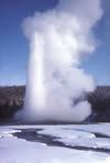
New research suggests that how often Old Faithful and other Yellowstone geysers erupt may depend on annual rainfall patterns. USGS scientist Shaul Hurwitz along with colleagues at Stanford and Yellowstone National Park have discovered that changes of water supply to a geyser's underground plumbing may have a large influence on eruption intervals; that is, the time between eruptions. For example, geysers appear to lengthen and shorten their intervals on cycles that mimic annual dry and wet periods. The study results were published in the article, Climate-induced variations of geyser periodicity in Yellowstone National Park, USA, in the June issue of the journal Geology. Geysers are rare hot springs that periodically erupt bursts of steam and hot water. Yellowstone National Park has more than half of the world's geysers. Old Faithful has remained faithful for at least the past 135 years, showering appreciative tourists every 50 to 95 minutes (most recently an annual average of 91 minutes). To view Old Faithful in real-time, see the National Park Service Old Faithful Webcam.
The University of Utah Seismograph Stations reports that a light earthquake of magnitude 4.1 occurred at 05:59 AM on March 25, 2008 (MDT) in Yellowstone National Park. The epicenter of the shock was located 29.8 km (18.6 mi) NE of Fishing Bridge, WY. Two earthquakes of magnitude 3.0 or greater have occurred within 25 km of the epicenter of this event since 1962. The largest of these events was a magnitude 3.5 on July 20, 1992, 6.4 km (4.0 mi) NE of Fishing Bridge, WY. No earthquakes of magnitude 4.5 or greater have occurred within 50 km of the epicenter of this event since 1962. This event has been reported felt in Pahaska Tepee, outside the east entrance to Yellowstone National Park and in southwest Montana as well as in western Wyoming.
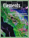
The February issue of Elements Magazine, features a number of articles on supervolcanoes, discussing their origins, growth and eruptions. YVO Scientist-in-Charge Jake Lowenstern and his USGS colleague Shaul Hurwitz have contributed an article entitled: "Monitoring a Supervolcano in Repose: Heat and Volatile Flux at the Yellowstone Caldera. The table of contents for the February issue of Elements can be downloaded here, though you or your library will need a subscription to download the other articles.
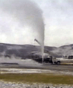
In the 1960's, USGS researchers drilled research wells to learn about the Yellowstone geothermal system. One of those wells, the Y8 at Biscuit Basin, started leaking in 1992, and was immediately capped and plugged by the USGS, the National Park Service, and a local drilling company. Because of its historic and scientific interest, a video of the operation was recently reformatted and published as USGS Open-File Report 2008-1014, which can be downloaded in a variety of formats. The video can also be streamed to your computer without downloading. Enjoy!
USGS scientists and their collaborators recently published a compendium of research papers about Yellowstone National Park. USGS Professional Paper 1717 is entitled: Integrated Geoscience Studies in the Greater Yellowstone Area - Volcanic, Tectonic, and Hydrothermal Processes in the Yellowstone Geoecosystem. The sixteen chapters include studies of geology, geochemistry and geophysics, including several with a focus on Yellowstone Lake. A separate map entitled: Bathymetry and Geology of the Floor of Yellowstone Lake, Yellowstone National Park, Wyoming, Idaho, and Montana, was also recently published.
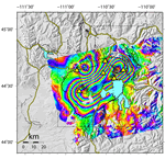
The November 9, 2007 issue of Science Magazine features an article, Accelerated uplift and magmatic intrusion of the Yellowstone Caldera, 2004 to 2006, by YVO scientists from the University of Utah and USGS. Using GPS and another satellite-based technique (InSAR), the authors find that parts of the Yellowstone Caldera rose as much as 7 cm (~3") per year from 2004 to 2006. The uplift is most noticeable at the White Lake GPS station, as has been discussed in our monthly YVO updates over the past year. Chang and his colleagues credit the relatively rapid uplift to magma entering the region beneath the Yellowstone Caldera. During this period of uplift, there have been relatively few earthquakes at Yellowstone. Heat and gas flow from the geysers and hot springs also remain unchanged. Calderas such as Yellowstone can display this sort of geologic behavior, even for centuries or millennia, without erupting. Read more about the uplift in our article Recent ups and downs of the Yellowstone Caldera. Also see the University of Utah press release.
Yellowstone Volcano Observatory (YVO) just released a Preliminary Assessment of Volcanic and Hydrothermal Hazards in Yellowstone National Park and Vicinity. The assessment, four years in the making, is authored by Robert Christiansen, a leading expert on the Yellowstone volcanic system, along with eight colleagues. The preliminary assessment has been published as an Open-File Report. Over the next 2 years, the assessment will be enlarged to include a seismic hazards analysis and other additional enhancements. At that point, the hazards assessment will be released as a more formal USGS Scientific Investigations Report that will replace this preliminary report.
In September 2005, USGS/YVO Postdoctoral Fellow Brita Graham Wall used a radio-controlled camera, attached to a helium-filled balloon to take photos from the sky above the Norris Geyser Basin. Some of the photos are truly spectacular, and we hope you enjoy them. Please see the images in the article Way Above Norris.
Yellowstone Volcano Observatory (YVO) has developed a monitoring plan for the period 2006-2015 to increase our ability to provide timely information during seismic, volcanic, and hydrothermal crises and to anticipate hazardous events before they occur. Upgrades to the monitoring network will provide high-quality data for scientific study and interpretation of one of the largest active volcanic systems in the world. Equipment additions and upgrades will bring the seismic network up to modern standards and add stations in areas that lack adequate station coverage. Borehole strainmeters and tiltmeters will be added to measure crustal movements and stream gages and gas-measuring instruments will allow YVO to compare geophysical phenomena, such as earthquakes and ground motions, to hydrothermal events, such as anomalous water and gas discharge. Please see the Volcano and Earthquake Monitoring Plan for the Yellowstone Volcano Observatory, 2006-2015 for more information.
Previous news stories are available in the YVO News Archive.
