
Bay Area Earthquake Probabilities
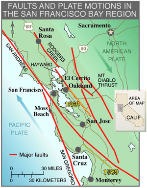
Figure 1. Faults and plate motions in the San Francisco Bay Region. Faults in the region, principally the seven faults shown here and characterized in this report, accommodate about 40 mm/yr of mostly strike-slip motion between the Pacific and North American tectonic plates. Yellow lines show the locations of the 1868 M6.8 earthquake on the southern portion of the Hayward Fault and the 1989 M6.9 Loma Prieta earthquake near the San Andreas fault northeast of Monterey Bay.
Earthquakes in the San Francisco Bay Region result from strain energy constantly accumulating across the region because of the northwestward motion of the Pacific Plate relative to the North American Plate (Figure 1 ). The region experienced large and destructive earthquakes in 1838, 1868, 1906, and 1989, and future large earthquakes to relieve this continually accumulating strain are a certainty. For our study we define the SFBR as extending from Healdsburg on the northwest to Salinas on the southeast. It encloses the entire metropolitan area, including its most rapidly expanding urban and suburban areas. We have used the term "major" earthquake as one with M>=6.7 (where M is moment magnitude). As experience from recent earthquakes in Northridge, California (M6.7, 1994, 20 killed, $20B in direct losses) and Kobe, Japan (M6.9, 1995, 5500 killed, $147B in direct losses), earthquakes of this size can have a profound impact on the social and economic fabric of densely urbanized areas.
To evaluate the probability of future large earthquakes in the San Francisco Bay Region, the U.S. Geological Survey has established a series of Working Groups on California Earthquake Probabilities (hereafter referred to as WG88, WG90, WG99). Each of these Working Groups has expanded on the work of its predecessors, applying, in turn, the data and methodology available at the time and drawing on input from broad cross-sections of the earth science community.
WG88 and WG90 established a framework for estimating earthquake probabilities based on simple physical models for the San Andreas and Hayward faults in the Bay Area, and on the San Andreas, San Jacinto, and Imperial Faults in southern California. WG99 extended this framework into a more comprehensive, regional one for the SFBR based on a greatly expanded set of geological and geophysical observations. In its calculations, WG99 combined the results of multiple viable models when a single consensus model did not exist. Summaries of WG99 methods and results were published in 1999 on the tenth anniversary of the Loma Prieta earthquake, as U.S. Geological Survey Open-File Report 99-517, and USGS Fact Sheet: Progress Toward a Safer Future Since the 1989 Loma Prieta Earthquake.
The present study (hereafter referred to as WG02) is a continuation and extension of WG99 and updates the results of that study. WG02 adopts the basic framework used by WG99 and expands on it by:
- incorporating additional data;
- more fully analyzing the possible effects of the 1906 earthquake (the "stress-shadow" effect) on the current earthquake potential in the SFBR;
- more fully developing the uncertainties associated with the calculated probabilities;
- exploring some of the implications for earthquake hazard in SFBR;
- making available a full documentation of the methods and computer codes used.
