 |
|
|
||||
| U.S. Geological Survey |
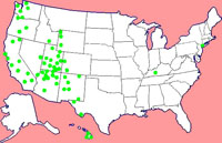
| Geology of National Parks 3D and Photographic Tours Featuring Park Geology and Natural History Click on a national park below to start an image tour. Or, use a Location Map, Thumbnail Gallery index, or selected Subject index. Standard photography websites mirror the 3D image websites. |
Name that park! Explore, interpret, and identify selected park landscapes with this online photo quiz game |
| New! Where's the Hayward Fault? Tour one of North America's most dangerous faults in California's East Bay Area |
|
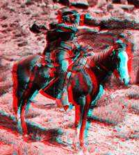
| New! Native American Indians of the Southwest, 1871-1875 |
|
| New! Yosemite historic images |
| Parks | 3D Image Galleries | Standard Images | .gov sites |
Selected On-line USGS Field Guides and WWW Resources |
All color photography on this website was taken by Phil Stoffer (USGS) unless otherwise stated on the image caption text. All images are "public domain." Click here for more information regarding copyright and fair use. |
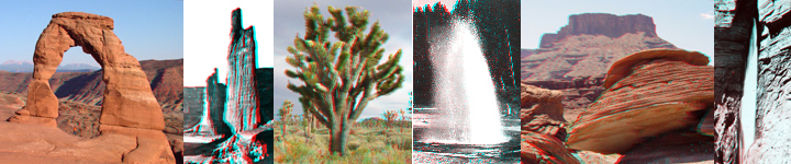
| Arches National Park | 3D | Photo | NPS | park stratigraphy | |
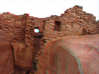
| Aztec Ruins National Monument | 3D | Photo | NPS | ||
| Badlands National Park | NPS | Geology of Badlands National Park | |||
| Big Bend National Park | 3D | Photo | NPS | park stratigraphy | |
| Bryce Canyon National Park | 3D | Photo | NPS | park stratigraphy | |
| Canyon de Chelley National Monument | 3D | Photo | NPS | park stratigraphy | |
| Canyonlands National Park (recent and historic) | 3D | Photo | NPS | park stratigraphy | |
| Capitol Reef National Park | 3D | Photo | NPS | park stratigraphy | |
| Capulin Volcano National Park | 3D | Photo | NPS | Raton-Clayton volcanic field, NM (CVO website) | |
| Carrizo Plain National Monument | 3D | Photo | BLM | Virtual Tour, Geologic Map | |
| Carlsbad Caverns National Park | 3D | Photo | NPS | ||
| Chaco Culture National Historic Park | 3D | Photo | NPS | Sources of Chacoan Maize | |
| City of Rocks National Reserve | 3D | Photo | NPS | ||
| Colorado National Monument | 3D | Photo | NPS | Geologic Map | |
| Columbia River Gorge National Scenic Area | 3D | Photo | NFS | Columbia River Gorge (CVO) | |
| Crater Lake National Park | 3D | Photo | NPS | Crater Lake Data Clearinghouse | |
| Death Valley National Park | 3D | Photo | NPS | Death Valley National Park | |
| Delaware Water Gap National Recreation Area | NPS | Delaware Water Gap to Port Jervis Gorge | |||
| Dinosaur National Monument (historical and recent) | 3D | Photo | NPS | park stratigraphy | |
| El Malpais National Monument | 3D | Photo | NPS | ||
| El Morro National Monument | 3D | Photo | NPS | ||
| Fire Island National Seashore |
NPS | Robert Moses SP/Fire Island National Seashore | |||
| Flaming Gorge National Recreation Area (Powell Survey, 1871) |
3D | Photo | NFS | park stratigraphy | |
| Fossil Butte National Monument | 3D | Photo | NPS | ||
| Gateway National Recreation Area | NPS | Sandy Hook, Breezy Point, Jamaica Bay | |||
| Glen Canyon National Recreation Area (historic and recent) |
3D | Photo | NPS | park stratigraphy | |
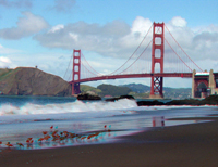
| Golden Gate National Recreation Area | 3D | Photo | NPS | Geology of the Golden Gate Headlands | |
| Golden Spike National Monument | 3D | Photo | NPS | ||
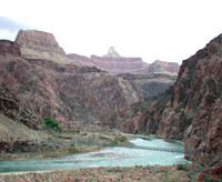
| Grand Canyon National Park | 3D | Photo | NPS | park stratigraphy, geologic map, research | |
| Grand Staircase-Escalante Nat'l Monument | 3D | Photo | BLM | park stratigraphy | |
| Grand Tetons National Park | 3D | Photo | NPS | ||
| Great Basin National Park | 3D | Photo | NPS | ||
| Guadalupe Mountains National Park | 3D | Photo | NPS | ||
| Hawaii Volcanoes National Park | 3D | Photo | NPS | Hawaiian Volcano Observatory | |
| Hovenweep National Monument | 3D | Photo | NPS | ||
| John Day Fossil Beds National Monument | 3D | Photo | NPS | ||
| Joshua Tree National Park | 3D | Photo | NPS | geologic maps | |
| Kaloko-Honokohau National Historic Park | 3D | Photo | NPS | ||
| Lake Mead National Recreation Area | 3D | Photo | NPS | geologic map | |
| Lava Beds National Monument | 3D | Photo | NPS | Medicine Lake and Lava Beds volcanic region | |
| Mammoth Cave National Park | 3D | Photo | NPS | ||
| Mesa Verde National Park | 3D | Photo | NPS | ||
| Mojave National Preserve | 3D | Photo | NPS | Mojave Desert Landforms & Surface Processes | |
| Mount Rainier National Park | 3D | Photo | NPS | Cascades Volcano Observatory - Mount Rainier | |
| Mount St. Helens National Volcanic Monument | 3D | Photo | NFS | Mount St. Helens (CVO) | |
| Natural Bridges National Monument | 3D | Photo | NPS | ||
| Navajo National Monument | 3D | Photo | NPS | ||
| North Cascades National Park | 3D | Photo | NPS | North Cascades NP Geology, (CVO) | |
| Olympic National Park | 3D | Photo | NPS | Geology of Olympic National Park | |
| Petrified Forest National Park | 3D | Photo | NPS | park stratigraphy | |
| Pinnacles National Monument | 3D | Photo | NPS | ||
| Pipe Spring National Monument | 3D | Photo | NPS | ||
| Point Reyes National Seashore | 3D | Photo | NPS | San Andreas Fault & Point Reyes Nat'l Seashore | |
| Puuhonua o Honaunau National Historic Park | 3D | Photo | NPS | ||
| Puukohola Heiau National Historic Site | 3D | Photo | NPS | ||
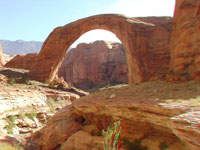
| Rainbow Bridge National Monument | 3D | Photo | NPS | ||
| Saguaro National Park | 3D | Photo | NPS | ||
| Sunset Crater National Monument | 3D | Photo | NPS | fact sheet, Arizona's volcanoes | |
| Walnut Canyon National Monument | 3D | Photo | NPS | park stratigraphy | |
| Wupatki National Monument | 3D | Photo | NPS | park stratigraphy | |
| Yellowstone National Park (historic and recent) | 3D | Photo | NPS | Yellowstone Volcano Observatory | |
| Yosemite National Park (historic) | 3D and Photo | NPS | The Geologic Story of Yosemite Valley | ||
| Zion National Park (recent & Powell Survey, 1872-3) | 3D | Photo | NPS | park stratigraphy | |
| Other park-related resources: | |||||
| Geology of National Parks: National Park Service Support Project | |||||
| Park Stratigraphy of the Colorado Plateau - a resource guide to regional geologic units | |||||
| Maps of the 4 Corners region of the American Southwest - Arizona, Colorado, New Mexico, and Utah | |||||
| Native American Indians of the Southwest, 1871-1975: a 3D Image tour of Early Photography Taken During the U.S. Geological and Geographical Surveys West of the 100th Meridian and the Powell Survey of the Colorado River Canyons. | |||||
| Powell Survey Expeditions (1871-1872) of the Colorado River Canyons (original stereo photography) | 3D | Photo | |||
| Geology of the New York City Region - visit 74 parks and areas of geologic interest in the NY-NJ-CN region | |||||
| Where's the San Andreas Fault? A Guidebook to Tracking the Fault on Public Lands in the San Francisco Bay Region | |||||
| Landslide Hazards of California - A Teachers Guide | |||||
| 3D Landscapes and Geology of the San Francisco Bay region | Monterey Bay region in 3D relief | ||||
| Where's the Hayward Fault? A Green Guide To The Fault | 1868 Hayward Earthquake Alliance | ||||
|
|||||
The 3D images are anaglyphs and require red and cyan 3D viewing glasses. These full-size images average 500 KB each and may be slow to download.
 |
A search on the World Wide Web will yield many sites about anaglyphs and where to get 3D glasses. To learn more about how anaglyphs (3D images) are made, click here. |
| AccessibilityFOIAPrivacyPolicies and Notices | |
 |
|