Natural Hazards
Back to Natural Hazards Gateway Home
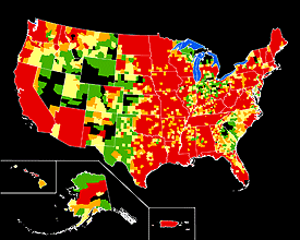 Presidential disaster declarations related to flooding in the United States, shown by county: Green areas represent one declaration; yellow areas represent two declarations; orange areas represent three declarations; red areas represent four or more declarations between June 1, 1965, and June 1, 2003. Map not to scale. Sources: FEMA, Michael Baker Jr., Inc., the National Atlas, and the USGS (Hi-res | Low-res) Natural Hazards - FloodsIn the late summer of 2005, the remarkable flooding brought by Hurricane Katrina, which caused more than $200 billion in losses, constituted the costliest natural disaster in U.S. history. However, even in typical years, flooding causes billions of dollars in damage and threatens lives and property in every State. Natural processes, such as hurricanes, weather systems, and snowmelt, can cause floods. Failure of levees and dams and inadequate drainage in urban areas can also result in flooding. On average, floods kill about 140 people each year and cause $6 billion in property damage. Although loss of life to floods during the past half-century has declined, mostly because of improved warning systems, economic losses have continued to rise due to increased urbanization and coastal development.
|
|
USGS Flood Related News (USGS Newsroom)
|
Highlighted Flood Resources Select the
|

![]() U.S. Department of the Interior |
U.S. Geological Survey
U.S. Department of the Interior |
U.S. Geological Survey
URL: http://www.usgs.gov/hazards/floods/default.asp
Page Contact Information: Ask USGS
Page Last Modified: Tuesday, July 08, 2008
