Natural Hazards
Back to Natural Hazards Gateway Home
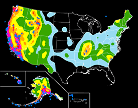
This map shows relative shaking hazards in the United States and Puerto Rico. During a 50-year time period, the probability of strong shaking increases from very low (white), to moderate (blue, green, and yellow), to high (orange, pink, and red). Map not to scale. Source: USGS (Hi-res | Low-res) Natural Hazards - EarthquakesEarthquakes are one of the most costly natural hazards faced by the Nation, posing a significant risk to 75 million Americans in 39 States. The risks that earthquakes pose to society, including death, injury, and economic loss, can be greatly reduced by (1) better planning, construction, and mitigation practices before earthquakes happen, and (2) providing critical and timely information to improve response after they occur. As part of the multi-agency National Earthquake Hazards Reduction Program, the U.S. Geological Survey (USGS) has the lead Federal responsibility to provide notification of earthquakes in order to enhance public safety and to reduce losses through effective forecasts based on the best possible scientific information.
|
|
Recent Earthquakes > Magnitude 5
USGS Earthquake Related News (USGS Newsroom)
|
Highlighted Earthquake Resources Select the
|

![]() U.S. Department of the Interior |
U.S. Geological Survey
U.S. Department of the Interior |
U.S. Geological Survey
URL: http://www.usgs.gov/hazards/earthquakes/default.asp
Page Contact Information: Ask USGS
Page Last Modified: Tuesday, July 08, 2008
