Search Assistance - Places
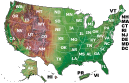
Click on the map or select from the list to browse links to USGS Programs, activities, and tools that provide information specific to that state.
The National Atlas of the United States of America®: The single best Federal source for national maps and geographic information on the Web. The people and places of the United States are here. Here you can play with interactive maps, learn about topics that interest you, and much more.
The National Map: The product of a consortium of Federal, State, and local partners who provide geospatial data to enhance America's ability to access, integrate, and apply geospatial data at global, national, and local scales.
Search for Geographic Place Names
Geographic Names Information System (GNIS): This database contains information for almost 2 million physical and cultural geographic features in the United States and its territories. The Federally recognized name of each feature described in the data base is identified, and references are made to a feature's location by State, county, and geographic coordinates. Search results provide links for viewing the topographic map and digital orthophoto (a black and white aerial view) of the feature.
Browse Recent Earthquake Listings
Recent Earthquakes: Locations of recent earthquakes are plotted on a U.S. or World Map. Click on a location to zoom in. Once maximum zoom is attained, click on one of the colored boxes to see information on that specific earthquake.
Search or Browse Water Resources
NWISWeb: This Web site provides access to water-resources data collected at approximately 1.5 million sites in all 50 States, the District of Columbia, and Puerto Rico. Online access to this data is organized around the categories of surface water, ground water, and water quality.
National Water-Quality Assessment Program: In more than 50 major river basins and aquifers covering nearly all 50 states, USGS scientists collect and interpret data about water chemistry, hydrology, land use, stream habitat, and aquatic life.
Geoscience Data Catalog: A catalog of earth science data produced by the U.S. Geological Survey.
Volcanic Hazards Information: By knowing the distance that previous types of activity spread from a volcano and the present landscape, and learning from the effects of historical eruptions, we can identify hazardous zones around a volcano.
View USGS Maps and Aerial Photos Online
USGS Geographic Information Office: Links to selected USGS Business Partner Program (BP) and Cooperative Research and Development Agreement (CRADA) partner sites where you may view USGS maps and aerial photo images from your Web browser.

![]() U.S. Department of the Interior |
U.S. Geological Survey
U.S. Department of the Interior |
U.S. Geological Survey
URL: http://search.usgs.gov/places.html
Page Contact Information: USGS Web
Page Last Modified: 20-Aug-2008, 17:46
