Maps & Photos
Region 10 Cleanup: Upper Columbia River
Serving the people of Alaska, Idaho, Oregon, Washington and 270 Native Tribes
Recent Additions
|
Contact Us
|
Print Version
Search:
EPA Home
>
Region 10
>
Cleanup Sites
>
Upper Columbia River
>
Region 10 Homepage
Region 10 Cleanup
Upper Columbia River
What You Can Do
Information Sources
Fact Sheets
In The News
Maps & Photos
Technical Documents
Enforcement
Related Links
Freedom of Information Act (FOIA)
Maps & Photos
Click on map to view a printable version.
Photos from sediment sampling in April/May 2005
11
Near China Bend, River Mile 722
10
Near International Border, River Mile 744
12
Black sand beach, Northport, WA 9/14/2002
13
Marcus Flats, River Mile 705
14
Grand Coulee Dam
Photos from April 2004 site visit to Upper Columbia River (click on photos for more detail)
Sand mixed with slag along shoreline of Upper Columbia River.
Beach area with heavy slag concentration.
Close-up of "black sand."
Black sand visible beneath surface of river.
[
Main Cleanup
|
Brownfields
]
[
Superfund
|
FOIA
|
Records Center
]
Point of contact: Jeanne O'Dell
E-Mail:
odell.jeanne@epa.gov
Phone Number: 1-800-424-4372, extension 6919
Last Updated: 11/06/2007
 11
11 10
10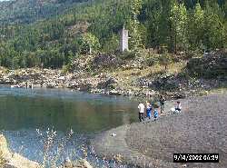 12
12