
|
projects > freshwater flows to northeastern florida bay
Freshwater Flows to Northeastern Florida Bay
|
Project Investigators:
Mark Zucker, Jeff Woods
Project Personnel: Christian Lopez, Shane Ploos, Carrie Boudreau, Stephen Huddleston
Project Start Date: 1994 End Date: --
Recent Funding: (FY07) ENP CESI, USGS GE PES, USACE, (FY06) ENP CESI, USGS GE PES, USACE, (FY05) USGS GE PES, USACE
|
Summary
|
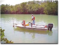
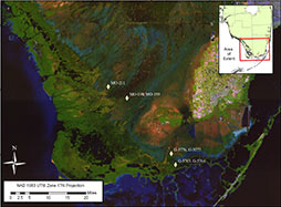
| The goal of this project is to calculate water discharge into Florida Bay. |
As part of the South Florida Ecosystem Program, the U.S. Geological Survey, in collaboration with Everglades National Park, the U.S. Army Corps of Engineers, and the South Florida Water Management District, is conducting a study to measure flows into east Florida Bay. Information from this study will be used in conjunction with data from other studies to help determine the effects of changes in water deliveries to Everglades National Park on the Florida Bay ecosystem. Flow into Florida Bay is closely related to sediment transport, salinity, and chemical characteristics of the bay, which in turn, determine and interact with biological characteristics. Additionally, freshwater-inflow data will be used as input to hydrodynamic models of Florida Bay, for calibration of hydrologic models of the mainland, and for water-budget determinations for south Florida-all of which are essential elements for resource management and the ecosystem restoration.
Proposals
Work Plans
Project Summaries
Data
Metadata
Publications
Abstracts
- A comparison of rated discharge at Jewfish Creek using a 0.5 MHz and a 1.5 MHz Argonaut-SL using different sampling volumes (from the National Surface Water Conference and Hydroacoustics Workshop, April 2007)
- Continuous Hydrologic Data in Florida Bay Channels (from the GEER Conference, April 2003)
- Determining Flows into Northeastern Florida Bay, Dade and Monroe Counties, Florida
- Distribution of Flows in Northeastern Florida (from the Florida Bay Conference Proceedings, 1998)
- Estimates of Nutrient Loads at West Highway Creek in Northeastern Florida Bay (from the 2005 Florida Bay and Adjacent Marine Systems Science Conference)
- Estimating Freshwater Flows into Northeastern Florida Bay (from the South Florida Restoration Science Forum, May 1999)
- Estimation of Freshwater Flow to Joe Bay, South Florida (from the 2002 Spring AGU Meeting)
- Estuarine Creek Responses to Extreme Hydrologic Events in Northeastern Florida Bay (from the GEER Conference, April 2003)
- Freshwater Flows into East Florida Bay (from the Florida Bay Conference Proceedings, 1995)
- Freshwater Flows into Northeastern Florida Bay (from the Florida Bay and Adjacent Marine Systems Science Conference, November 1999)
- Northeastern Florida Bay and Joe Bay Estuarine Creek Data, 2001-2005 (from the GEER Conference, June 2006)
- Northeastern Florida Bay Estuarine Creek Response During the 2004-05 Hurricane Seasons (from the GEER Conference, June 2006)
- Nutrient loading at Card Sound Canal - A tidally driven canal that experiences highly stratified, bidirectional flow conditions (from the November 2007 USGS National Water Quality Workshop)
- Quantity, Timing, and Distribution of Freshwater Flows into Northeastern Florida Bay (from the GEER Conference, December 2000)
- Quantity, Timing, and Distribution of Freshwater Flows into Northeastern Florida Bay (2) (from the Florida Bay Science Conference, April 2001)
- Temporal and Spatial Salinity Patterns in Joe Bay, Everglades National Park (from the GEER Conference, July 2008. This is a 3.5MB PDF and requires the FREE Adobe Acrobat Reader®)
- Using Hydrologic Correlation as a Tool to Estimate Flow at Non-Instrumented Estuarine Creeks in Northeastern Florida Bay (from the GEER Conference, April 2003)
- Using Hydrologic Monitoring as a Tool for Synthesis of the Greater Everglades and Southern Estuaries Modules of the Monitoring and Assessment Plan (from the GEER Conference, July 2008. This is a 3.5MB PDF and requires the FREE Adobe Acrobat Reader®)
Circulars
Digital Data Series
Fact Sheets
Maps
Posters
Presentations
Reports
- 2004 Water Resources Data for Florida, 2004, Volume 2A: South Florida Surface Water USGS Water-Data Report FL-04-2A (Search all reports for the year. Please note individual manuscript files that follow are PDF files which require the FREE Adobe Acrobat Reader® to be read.)
- 2004 Everglades and Southeastern Coastal Area: 251003080435500 McCormick Creek at Mouth, FL (PDF file)
- 2004 Everglades and Southeastern Coastal Area: 251127080382100 Taylor River at Mouth Near Homestead, FL (PDF file)
- 2004 Everglades and Southeastern Coastal Area: 251209080350100 Mud Creek at the Mouth Near Homestead, FL (PDF file)
- 2004 Everglades and Southeastern Coastal Area: 251253080320100 Trout Creek at Mouth, FL (PDF file)
- 2004 Everglades and Southeastern Coastal Area: 251341080291200 Stillwater Creek Near Homestead, FL (PDF file)
- 2004 Everglades and Southeastern Coastal Area: 251433080265000 West Highway Creek, FL (PDF file)
- 2005 Water Resources Data for Florida, 2005, Volume 2A: South Florida Surface Water USGS Water-Data Report FL-05-2A (Search all reports for the year. Please note individual manuscript files that follow are PDF files which require the FREE Adobe Acrobat Reader® to be read.)
- 2005 Big Cypress Swamp and Southwestern Coastal Area: 022908295 Bottle Creek at Rookery Branch Near Homestead, FL (PDF file)
- 2005 Big Cypress Swamp and Southwestern Coastal Area: 252019080544800 Upstream North River Near Flamingo, FL (PDF file)
- 2005 Big Cypress Swamp and Southwestern Coastal Area: 252551081050900 Harney River Near Flamingo, FL (PDF file)
- 2005 Big Cypress Swamp and Southwestern Coastal Area: 253047080555600 Upstream Broad River Near Everglades City, FL (PDF file)
- 2005 Big Cypress Swamp and Southwestern Coastal Area: 253357080594100 Upstream Lostman's River Near Everglades River, FL (PDF file)
- 2005 Everglades and Southeastern Coastal Area: 251003080435500 McCormick Creek at Mouth, FL (PDF file)
- 2005 Everglades and Southeastern Coastal Area: 251032080432200 Seven Palm Lake Near Flamingo, FL (PDF file)
- 2005 Everglades and Southeastern Coastal Area: 251105080231800 Jewfish Creek at U.S. 1, Key Largo, FL (PDF file)
- 2005 Everglades and Southeastern Coastal Area: 251127080382100 Taylor River at Mouth Near Homestead, FL (PDF file)
- 2005 Everglades and Southeastern Coastal Area: 251209080350100 Mud Creek at the Mouth Near Homestead, FL (PDF file)
- 2005 Everglades and Southeastern Coastal Area: 251241080385300 Upstream Taylor River Near Homestead, FL (PDF file)
- 2005 Everglades and Southeastern Coastal Area: 251253080320100 Trout Creek at Mouth, FL (PDF file)
- 2005 Everglades and Southeastern Coastal Area: 251322080352500 Joe Bay 8W Near Key Largo, FL (PDF file)
- 2005 Everglades and Southeastern Coastal Area: 251338080312600 Joe Bay 1E Near Key Largo, FL (PDF file)
- 2005 Everglades and Southeastern Coastal Area: 251341080291200 Stillwater Creek Near Homestead, FL (PDF file)
- 2005 Everglades and Southeastern Coastal Area: 251355080312800 Joe Bay 2E Near Key Largo, FL (PDF file)
- 2005 Everglades and Southeastern Coastal Area: 251422080271900 Oregon Creek Near Key Largo, FL (PDF file)
- 2005 Everglades and Southeastern Coastal Area: 251433080265000 West Highway Creek, FL (PDF file)
- 2005 Everglades and Southeastern Coastal Area: 251438080333500 Joe Bay 5C Near Key Largo, FL (PDF file)
- 2005 Everglades and Southeastern Coastal Area: 251440080262800 East Highway Creek Near Key Largo, FL (PDF file)
- 2005 Everglades and Southeastern Coastal Area: 251457080395800 Taylor Slough Wetland at E146 Near Homestead, FL (PDF file)
- 2005 Everglades and Southeastern Coastal Area: 251549080251200 Manatee Bay Creek Near Homestead, FL (PDF file)
- 2005 Everglades and Southeastern Coastal Area: 251740080311200 C-111 Wetland Near Homestead, FL (PDF file)
- 2005 Everglades and Southeastern Coastal Area: 251816080232200 Card Sound Canal Near Homestead, FL (PDF file)
- 2006 Water Resources Data for the United States Water Year 2006 (Search all reports for the year. Please note individual manuscript files that follow are PDF files which require the FREE Adobe Acrobat Reader® to be read.)
- 2006 Southern Florida Basin, Big Cypress Swamp Subbasin: 02290928 Barron River at Everglades City, FL (PDF file)
- 2006 Southern Florida Basin, Big Cypress Swamp Subbasin: 02290930 Turner River Near Chokoloskee Island, FL (PDF file)
- 2006 Southern Florida Basin, Big Cypress Swamp Subbasin: 02290940 New River at Sunday Bay, FL (PDF file)
- 2006 Southern Florida Basin, Big Cypress Swamp Subbasin: 02290942 Lopez River Near the Lopez Campsite, FL (PDF file)
- 2006 Southern Florida Basin, Everglades Subbasin: 022908205 North River Upstream of Cutoff Near Flamingo, FL (PDF file)
- 2006 Southern Florida Basin, Everglades Subbasin: 022908295 Bottle Creek at Rookery Branch Near Homestead, FL (PDF file)
- 2006 Southern Florida Basin, Everglades Subbasin: 02290878 Broad River Near the Cutoff, FL (PDF file)
- 2006 Southern Florida Basin, Everglades Subbasin: 02290888 Chatham River Near the Watson Place , FL (PDF file)
- 2006 Southern Florida Basin, Everglades Subbasin: 02290918 Lostman's River Below Second Bay, FL (PDF file)
- 2006 Southern Florida Basin, Everglades Subbasin: 251003080435500 McCormick Creek at Mouth, FL (PDF file)
- 2006 Southern Florida Basin, Everglades Subbasin: 251032080432200 Seven Palm Lake Near Flamingo, FL (PDF file)
- 2006 Southern Florida Basin, Everglades Subbasin: 251105080231800 Jewfish Creek at U.S. 1, Key Largo, FL (PDF file)
- 2006 Southern Florida Basin, Everglades Subbasin: 251127080382100 Taylor River at Mouth Near Homestead, FL (PDF file)
- 2006 Southern Florida Basin, Everglades Subbasin: 251209080350100 Mud Creek at the Mouth Near Homestead, FL (PDF file)
- 2006 Southern Florida Basin, Everglades Subbasin: 251241080385300 Upstream Taylor River Near Homestead, FL (PDF file)
- 2006 Southern Florida Basin, Everglades Subbasin: 251253080320100 Trout Creek at Mouth, FL (PDF file)
- 2006 Southern Florida Basin, Everglades Subbasin: 251322080352500 Joe Bay 8W Near Key Largo, FL (PDF file)
- 2006 Southern Florida Basin, Everglades Subbasin: 251338080312600 Joe Bay 1E Near Key Largo, FL (PDF file)
- 2006 Southern Florida Basin, Everglades Subbasin: 251341080291200 Stillwater Creek Near Homestead, FL (PDF file)
- 2006 Southern Florida Basin, Everglades Subbasin: 251355080312800 Joe Bay 2E Near Key Largo, FL (PDF file)
- 2006 Southern Florida Basin, Everglades Subbasin: 251422080271900 Oregon Creek Near Key Largo, FL (PDF file)
- 2006 Southern Florida Basin, Everglades Subbasin: 251433080265000 West Highway Creek, FL (PDF file)
- 2006 Southern Florida Basin, Everglades Subbasin: 251438080333500 Joe Bay 5C Near Key Largo, FL (PDF file)
- 2006 Southern Florida Basin, Everglades Subbasin: 251440080262800 East Highway Creek Near Key Largo, FL (PDF file)
- 2006 Southern Florida Basin, Everglades Subbasin: 251457080395800 Taylor Slough Wetland at E146 Near Homestead, FL (PDF file)
- 2006 Southern Florida Basin, Everglades Subbasin: 251549080251200 Manatee Bay Creek Near Homestead, FL (PDF file)
- 2006 Southern Florida Basin, Everglades Subbasin: 251740080311200 C-111 Wetland Near Homestead, FL (PDF file)
- 2006 Southern Florida Basin, Everglades Subbasin: 251816080232200 Card Sound Canal Near Homestead, FL (PDF file)
- 2006 Southern Florida Basin, Everglades Subbasin: 252019080544800 Upstream North River Near Flamingo, FL (PDF file)
- 2006 Southern Florida Basin, Everglades Subbasin: 252230081021300 Shark River Near Gunboat Island Near Flamingo, FL (PDF file)
- 2006 Southern Florida Basin, Everglades Subbasin: 252551081050900 Harney River Near Flamingo, FL (PDF file)
- 2006 Southern Florida Basin, Everglades Subbasin: 253044080555900 Eden 3 in Everglades National Park, FL (PDF file)
- 2006 Southern Florida Basin, Everglades Subbasin: 253357080594100 Upstream Lostman's River Near Everglades River, FL (PDF file)
Water Resources Investigations Reports
Related Links
Photos
|

 South Florida Coastal Real-Time Ground Water Stations
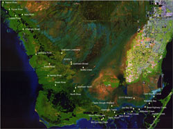 South Florida Coastal Real-Time Surface Water Stations