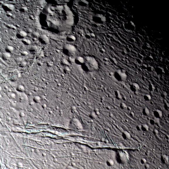
During its closest flyby of Saturn's wrinkled, icy moon Enceladus,
Cassini obtained multi-spectral images of its cratered terrain that have
been put together to create this false-color view.
To human eyes, Enceladus appears almost completely white, but false color
reveals intriguing details. This view is a composite of images taken using
filters sensitive to ultraviolet (centered at 338 nanometers), green
(centered at 568 nanometers), and near-infrared (centered at 930
nanometers) light, and has been processed to accentuate subtle color
differences. The uppermost surface of these terrains appears uniformly
grey in this picture, suggesting that they are covered with materials of
homogeneous composition and grain size. However, the walls of many of the
fractures appear to be somewhat bluer than typical surface materials. It
is possible that the difference in color identifies outcrops of solid ice
on the walls of fractures, or ice with different grain-sizes, compared to
powdery surface materials. It is also possible that the color identifies
some compositional difference between buried ice and ice at the surface.
The surface is peppered with craters of all sizes, from the 21-kilometer
(13-mile) diameter crater at the top of the image, down to tiny craters
near the limit of resolution. The prominent crater at the top contains a
central, domelike structure more than 11 kilometers (7 miles) in diameter.
The dome, the crater--and indeed the entire scene--is sliced by a complex
network of fractures ranging in width from hundreds of meters in some
places, to over three kilometers (2 miles) in others.
The prominent, complex fracture in the bottom of the frame extends over
85 kilometers (53 miles) in length across the field of view. From
Cassini's oblique vantage point, the walls of the large fracture are
clearly visible. A pervasive network of narrow, parallel grooves can be
seen in many places in the image, and they appear to slice the surface
into parallel slabs of ice approximately 500 meters (1,600 feet) in
thickness.
The image has been rotated so that north is at the top of the scene. The
terrain in this scene is located on the side of Enceladus that faces away
from Saturn, centered on latitude 28.7 north, longitude 192.5 west.
The image was taken during Cassini's closest-ever approach to Enceladus
on March 9, 2005. It was taken with the Cassini spacecraft narrow-angle
camera at a distance of approximately 21,300 kilometers (13,200 miles)
from Enceladus and at a Sun-Enceladus-spacecraft, or phase, angle of 45
degrees. Resolution in the image is about 130 meters (430 feet) per pixel.
The Cassini-Huygens mission is a cooperative project of NASA, the European
Space Agency and the Italian Space Agency. The Jet Propulsion Laboratory,
a division of the California Institute of Technology in Pasadena, manages
the mission for NASA's Science Mission Directorate, Washington, D.C. The
Cassini orbiter and its two onboard cameras were designed, developed and
assembled at JPL. The imaging team is based at the Space Science
Institute, Boulder, Colo.
For more information about the Cassini-Huygens mission, visit
http://saturn.jpl.nasa.gov and the Cassini imaging team home page,
http://ciclops.org.

