
|
|
|
|
July 20, 2006
A weekly feature provided by scientists at the Hawaiian Volcano Observatory.
Hot opportunities afoot for Mount St. Helens volcano watchers
|
|
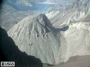
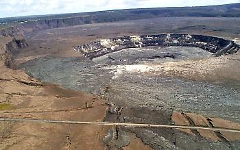
| Left: North view of MSH crater/dome. Right: Aerial view of Halema`uma`u Crater. | |
Kilauea Volcano and Hawai`i Volcanoes National Park have given millions of people an opportunity to witness the creation of new crust at the earth's surface. Many lucky souls have stood near slowly advancing pahoehoe flows on Kilauea's coastal plain and marvelled at the sight of lava entering the ocean. Kilauea's reputation as a "tourist's volcano" is well-deserved.
Well, move over, Kilauea, 'cause starting this weekend, Mount St. Helens' crater rim has been opened to public access!
Since the onset of Mount St. Helens' current eruption in the fall of 2004, areas around the volcano had been closed to hikers due to risks from volcanic explosions. The U.S. Forest Service, tender of the Mount St. Helens National Volcanic Monument, has opened hiking trails around the base of the volcano and is allowing as many as 100 visitors a day to climb up to the crater rim at about the 2,400-m (8,000-foot) elevation.
If any of you volcano watchers are planning a trip to the west coast this summer, you can check out a very different kind of eruption. Logistical information and safety guidelines for Mount St. Helens climbers can be found online at http://fs.fed.us/gpnf/recreation/mount-st-helens.
The U.S. Geological Survey is responsible for monitoring volcanic activity and advising the Forest Service on volcanic hazards. Daily updates of Mount St. Helens' activity and recent eruption images are posted on the USGS Cascades Volcano Observatory Web site at http://vulcan.wr.usgs.gov .
Public access restrictions are being lifted because Mount St. Helens has settled into a steady and fairly predictable eruptive pattern. From mid-October 2004 to March 2005, the amount of lava being erupted in the crater decreased from 600,000 to about 150,000 cubic meters a day, and has since gradually diminished to less than half the latter amount. By comparison, the average long-term daily output of the Pu`u `O`o-Kupaianaha eruption is approximately 400,000 cubic meters (525,000 cubic yards) per day.
The total volume of dacite lava added to the crater at Mount St. Helens is now 81 million cubic meters (106 million cubic yards), roughly the amount you'd need to fill Kilauea's Halemaumau pit crater twice over. If you were to picture the new Mount St. Helens dome in Halemaumau, the footprint of this pile of crumpled lava spines would occupy about half of the crater floor. The top of the dome would tower 180 m (600 ft) above the rim to visitors' eye level at the Jaggar Museum overlook.
At the current eruption rate, it would take around 100 years to rebuild the peak of Mount St. Helens that was blasted away on May 18, 1980, but chances are that this eruption will peter out long before that happens.
The steady heartbeat of small, shallow earthquakes that have been a trademark of Mount St. Helens' eruptions has, for the past few weeks, diminished to a barely perceptible murmur. Such lulls in background seismicity have, however, happened before and do not portend the end of the eruption. To the contrary, the lack of earthquakes seemed to signify the relative ease with which the near-solid plug of silica-rich magma has been rising through the shallow conduit and onto the crater floor. The latest lava spine continues to grow at the rate of a pickup-truck-load per second, despite barely detectable seismicity.
Gas emissions from Mount St. Helens remain low, and the lava forming the dome is largely degassed and nearly solid when it reaches the surface. These conditions, combined with the lack of deep earthquakes and regional ground deformation that would signify magmatic recharge, indicate that the potential for a catastrophic explosive event at Mount St. Helens remains low.
In spite of the overall low seismiscity, on July 18, within days of the announcement of public access to the crater rim, one of the largest earthquakes associated with this eruption occurred. A 3.6-magnitude shaker originating beneath the growing spine triggered rockfalls from the dome that sent plumes of steamy ash and dust above the crater rim.
This should serve as a potent reminder of the risks inherent in volcano watching and the need to pay close attention to eruption reports and established restrictions and guidelines before venturing forth to experience these awesome forces of nature.
Activity update
Eruptive activity at Pu`u `O`o continues. On clear nights, glow is visible from several vents within the crater. Lava continues to flow through the PKK lava tube from its source on the flank of Pu`u `O`o to the ocean, with surface flows breaking out of the tube at the 2,300-2,200-ft elevation. The most persistent of these is the "Campout flow," which has reached the coastal plain, where it is approximately 1.8 km (1.1 mi) from the ocean at Ka`ili`ili.
Lava is still entering the ocean at East Lae`apuki, in Hawai`i Volcanoes National Park. The lava bench continues to grow following the major collapse of November 28 and is now approximately 1,100 m (3,600 ft) long by 350 m (1,150 ft) wide, with a total surface area of 24 ha (60 acres).
Access to the sea cliff near the ocean entry is closed, due to significant hazards. The National Park has reopened the surrounding area, however. If you visit the eruption site, check with the rangers for current updates, and remember to carry lots of water when venturing out onto the flow field.
No earthquakes beneath Hawai`i Island were reported felt in the past week.
Mauna Loa is not erupting. During the past week, earthquake activity remained low beneath the volcano's summit, with three short-period earthquakes located at intermediate depths. Extension of distances between locations spanning the summit, indicating inflation, continues at slow rates.
Visit our web site (hvo.wr.usgs.gov) for daily Kilauea eruption updates and nearly real-time Hawai`i earthquake information.
![]()
![]()
![]()
![]()
![]()
![]()

![]()
![]()
![]()
![]()
Contact: hvowebmaster@usgs.gov
Updated: July 24, 2006 (pnf)