|

Discovery
Scientist Keeps Ben Franklin's Legacy Alive

Adriana Bailey of the Cooperative Institute for Research in Environmental Sciences interviews Yannick Meillier about using kites and aerodynamic blimps in his research
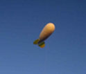
Scientists prepare to launch a balloon to test an emergency deflation system designed for the blimp.
Credit and Larger Version |
April 18, 2008
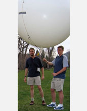
Tell Colorado scientist Yannick Meillier to go fly a kite and he just might take you seriously. A researcher at the Cooperative Institute for Research in Environmental Sciences at the University of Colorado at Boulder, Meillier is part of a team--including Ben Balsley, Rod Frehlich and Mike Jensen--that uses kites and aerodynamic blimps, called Tethered Lifting Systems, for research. With support from the National Science Foundation (NSF) and the National Oceanic and Atmospheric Administration (NOAA), the team studies the nocturnal stable boundary layer, the lowest layer of the nighttime atmosphere that extends from the Earth's surface up to a few hundred meters. During the day, the boundary layer is where the Earth's weather plays out, but just what happens there at night? CIRES: Most scientists looking to understand Earth's atmosphere take in situ measurements from towers or planes, but your research team has a unique way of getting instruments up into the air... Yannick Meillier: Right, it started with Ben Balsley, a lead scientist in our group. Ben came from NOAA, where he had been using kites for research on the atmospheric electric field. Wow! That harkens back to Ben Franklin flying a key on a kite in a lightning storm. Meillier: Yes, and people had given up on kites because new technologies came out, like planes and untethered weather balloons. But you can still get unique high-resolution data from kites and blimps. What kind of advantages would a kite or blimp have over a plane or tower? Meillier: Planes travel pretty fast and they can't fly low. We can deploy anywhere, and at any height, and the instruments can remain at one spot for hours at a time. Towers can take continuous data, but they're limited in height to a few hundred meters. They're also expensive to set up and definitely not portable. What types of measurements help you study the atmosphere? Meillier: We have two different kinds of instruments. The first kind tells us about turbulence by measuring fluctuations in temperature and horizontal windspeed, 1,000 times a second. The second kind is a basic meteorological payload equipped with instruments that measure wind speed and direction, temperature and altitude. Why is turbulence important to measure? Meillier: Turbulence tells you about the mixing properties of the atmosphere, how gases, including human-made pollutants, will be transported and diffused. It's also used to determine the structure of the atmosphere, which is between night and day. If your goal is to study nocturnal atmospheric processes, how much of your fieldwork takes place during the night? Meillier: All of it. The last field campaign we did, we used to meet around 7 p.m. Sunset was around 8:30 p.m. We'd work all night until sunrise. That's a long work shift. How do you kill time when you're out there? Meillier: Talk, at most. You're so busy controlling the system, worrying about the atmospheric conditions, checking the data as they come in to make sure everything is running smoothly, you don't have time to do anything else. So how do you get a Tethered Lifting System blimp to a field site and launch it? Meillier: Everything is packed inside a big container, like the kind that go on semi trucks. You have to take out the winch, plug in the power cord, set up the lights, and then you have to start setting up the balloon, which is partially deflated. So you bring your helium tanks and start inflating. Once it's almost done, you start putting tails on; each one has ten lines that you have to attach to the balloon. It takes about an hour. Then you set up your computers, because we get real-time feedback from our instruments. A semi truck-size trailor? How big is your blimp? Meillier: The blimp is 25 cubic meters (about 880 cubic feet) in volume. It's really a big balloon, but it's not spherical. It's aerodynamic, like a mini-zeppelin without a motor or propellers. How do you attach the instruments to the blimp? Meillier: We have a system of carabineers, like what climbers use, and they lock on the tether line that connects the blimp to the ground. The tether line is pretty strong; it's tested for 1,000 pounds of tension. What kind of research sites do you work at? Meillier: It's tough to find a site since we are flying an object with a tether line attached to it. You can't fly above 50 feet, without air traffic permission. So every time we want to deploy, we have to contact the FAA. Other than that, we can go pretty much anywhere, from rural to urban areas. A few months ago, we made measurements next to a tall tower near Boulder, Colo., a research site owned by NOAA. We took high resolution temperature measurements there to support and complement other scientists studying carbon-cycle gases from the tower. Before that, we were part of a major campaign at the U.S. Pentagon, where we studied local atmospheric processes to help the government plan its response strategy to a possible airborne, hazardous material attack. -- Adriana Bailey, Cooperative Institute for Research in Environmental Sciences, University of Colorado (303) 492-6289 adrianar@cires.colorado.edu This Behind the Scenes article was provided to LiveScience in partnership with the National Science Foundation.
Investigators
Yannick Meillier
Ben Balsley
Rod Frehlich
Michael Jensen
Related Institutions/Organizations
University of Colorado at Boulder
Locations
Colorado
Related Programs
Physical and Dynamic Meteorology
Related Awards
#0631966 Developing Improved Models of the Stable Boundary Layer Incorporating the Residual Layer Region
#0128089 Studies of High-Resolution Turbulence, Stratification, and Instabilities in the Nighttime Boundary Layer
#9907289 The Stable Nocturnal Boundary Layer: Observations and Interpretation of Mesoscale Instability Processes and Small-Scale Turbulent Breakup in the Absence/Presence of a Nocturnal Jet
#0522004 Boundary Layer Structure and Evolution During Terrain-induced Rotor EXperiment (T-REX)
Total Grants
$1,505,593
Related Agencies
National Oceanic and Atmospheric Administration (NOAA)
Related Websites
LiveScience.com: Go Fly a Kite: Scientist Keeps Ben Franklin's Legacy Alive: /news/longurl.cfm?id=64
|