
USGS/Cascades Volcano Observatory, Vancouver, Washington
Volcanic Hazards and Phenomena
Graphics - Maps, Charts, Tables, etc.
-
 Graphic [44K,GIF]
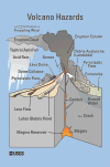
Schematic drawing of various Volcanic Hazards, 2000 Version
-- Graphic depicting various features of an erupting volcano ...
[2000 version, PDF Format, 420 K] ...
[2000 version, TIF Format, 25 M, 300dpi]
-
 [Graphic,12K,GIF]
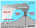
Schematic drawing of erupting volcano showing tephra types
-- Modified from: Gardner, et.al., 1995, USGS Open-File Report 95-498
-
 [Map,14K,InlineGIF]
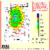
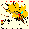
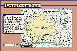
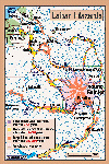
Annual probablility of 10 centimeters or more of tephra accumulation in
Washington and Oregon from major Cascade volcanoes
-- Modified from:
Scott, et.al., 1995, USGS Open-File Report 95-492
-
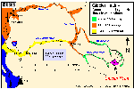
The most serious tephra hazards in the region
are due to Mount St. Helens,
the most prolific producer of tephra in the Cascades
during the past few thousand years. This map
provides estimates of the annual probability of
tephra fall affecting the region,
based on the combined likelihood of
tephra-producing eruptions occurring at
Cascade volcanoes, the relationship between
thickness of a tephra-fall deposit and distance
from its source vent, and regional wind patterns.
Probability zones extend farther east of the
range because winds blow from westerly directions
most of the time. The map shows probabilities for a fall of
10 cm (about 4 in) or greater.
Northern Skamania County has an annual
probability of a tephra fall of 10 cm or more of about 1 in
100 (1%) to 1 in 500 (0.2%).
Even though Mount Adams is a meager tephra producer, the region
around Mount Adams has the highest probability of
tephra fall of anywhere in the western conterminous United States,
owing to its location just downwind of Mount St. Helens.
-
Volcanic Hazards Reports and Maps for the Cascade Range, Maps in PDF
Format
-
 [3 M,PDF]
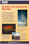
POSTER #1 - "Why Volcanic Risk in Increasing in the United States"
-- in PDF Format
-
 [3.0M,PDF]
POSTER #2 - "Strategy for Reducing Volcanic Risk"
-- in PDF Format
-
 [2.3M,PDF]
POSTER #3 - "Preparing for Volcanic Emergencies: Keeping You Informed"
-- PDF Format
-
 [Map,21K,InlineGIF]
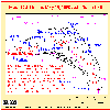
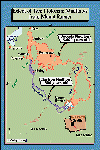
Mount St. Helens area showing May 18, 1980 devastation
-- From: Tilling, et.al., 1990
-
 [Map,17K,InlineGIF]
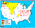
Distribution of May 18, 1980 ash fallout within the United States
-- From: Tilling, et.al., 1990
-
 [Map,22K,InlineGIF]
May 18, 1980 Ash Plume Path
-- Modified from: Sarna-Wojcicki, et.al., 1981, IN:
USGS Professional Paper 1250
-
 [Map,32K,InlineGIF]
Lakes North of Mount St. Helens Affected by the May 18, 1980 Eruption
-- Modified from: Dion and Embrey, 1981, USGS Circular 850-C, and
Embrey and Dion, 1988, WRI-87-4263
-
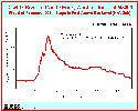 [Graphic,11K,GIF]
Flood of February 1996 - Cowlitz River at Castle Rock
-- stage adjusted to feet above sea level (NAVD88)
-
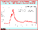 [Graphic,12K,GIF]
Flood of February 1996 - Toutle River at Tower Road
-- stage in feet above gage (1929NGVD)
-
 [Map,21K,InlineGIF]
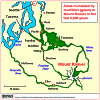
Areas inundated by debris flows from Glacier Peak eruptions
-- From: Mastin and Waitt, 1995, USGS Open-File Report 95-413
-
[Map,270K,PDF]
-- Hazards zones for lahars, lava flows, and pyroclastic flows from
Mount Rainier
-- PDF Format
-- From: Scott, et.al., 1998, USGS Fact Sheet 065-97, based on
Hoblitt, et.al., 1998, USGS Open-File Report 98-428
-
 [Map,20K,InlineGIF]
Extent of the Osceola and Electron Mudflows from Mount Rainier
-- Modified from: Crandell, et.al., 1979
-
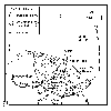
 [Map,23K,GIF]
Map showing areas inundated by mudflows from Mount Rainier in the
last 5,600 years
-- Modified from: Sisson, 1995, USGS Open-File Report 95-642
-
 [Map,183K,JPG]
"Poster-Style" Map of the Osceola and Electron Mudflows at Mount Rainier
-
 [Map,313K,JPG]
"Poster-Style" Map of Lava and Pyroclastic Flow Hazards at Mount Rainier
-
 [Map,363K,JPG]
"Poster-Style" Map of Lahar Hazards at Mount Rainier
-
 [Map,209K,JPG]
"Poster-Style" Map of Ashfall Hazards at Mount Rainier
-
 [Map,22K,GIF]
Volcanic hazards at Mount Hood related to growth of a lava dome
-- From: Brantley and Scott, 1993
-
 [Map,22K,GIF]
Volcanic hazards at Mount Hood
related to growth of a lava dome near Crater Rock
-- From: Brantley and Scott, 1993
-
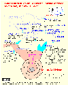
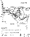
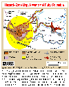 Map [40K,InlineGIF]
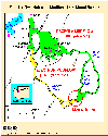
Map showing hazards expected from and eruption of Nevado del Ruiz,
Colombia. Such a map was prepared by INGEOMINAS (Colombian Institute of Geology
and Mines) and circulated one month prior to the November 13, 1985, eruption of
Nevado del Ruiz. Map shows danger from mudflows in the valley occupied by the
town of Armero, Colombia, as well as areas affected by the hazards that resulted
from this eruption. Circle denotes 20-kilometer limit.
-- Modified from: Wright and Pierson, 1992, USGS Circular 1073
Return to:
[Volcano and Hydrologic Hazards Menu] ...

URL for CVO HomePage is:
<http://vulcan.wr.usgs.gov/home.html>
URL for this page is:
<http://vulcan.wr.usgs.gov/Hazards/Graphics/framework.html>
If you have questions or comments please contact:
<GS-CVO-WEB@usgs.gov>
12/04/06, Lyn Topinka
 Graphic [44K,GIF]
 [Graphic,12K,GIF]
 [Graphic,11K,GIF]
 [Graphic,12K,GIF]
 [Map,23K,GIF]
 [Map,183K,JPG]
 [Map,313K,JPG]
 [Map,363K,JPG]
 [Map,209K,JPG]
 [Map,22K,GIF]
 [Map,22K,GIF]