-
 [Interactive Imagemap] ...
[Map,150K,GIF]
[Interactive Imagemap] ...
[Map,150K,GIF]
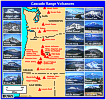
Cascade Range Volcanoes
-- Graphic by: Lyn Topinka, 1996
-
 [Map,20K,InlineGIF]
Major West Coast Volcanoes - Washington, Oregon, and California
-
 [Map,27K,InlineGIF]
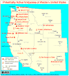
Potentially Active Volcanoes of the Western United States
-- Modified from: Brantley, 1994, Volcanoes of the United States:
USGS General Interest Publication
-
 [Graphic,70K,InlineGIF]
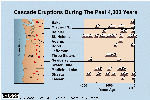
Cascades Eruptions During the Past 4000 Years
-
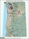
Seismic Monitoring at Cascade Volcanic Centers - The Big Picture
Informational text and shaded relief map
showing locations of all PNSN/NCSN seismic stations operating in the Pacific Northwest as of November, 2003. Map includes the 13 major Cascade volcanic centers.
-- Excerpt from: Moran, 2005, USGS Scientific Investigations Report 2004-5211
-
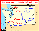 [Map,18K,InlineGIF]
Washington State and the Columbia River.
-- major volcanoes including Mount Baker
-
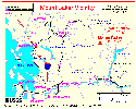 [Map,24K,InlineGIF]
Northwest Washington: Mount Baker, Mount Shuksan, and Vicinity
-- Modified from:
Hoblitt, et.al., 1987, USGS Open-File Report 87-297
-
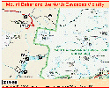
 [Map,31K,InlineGIF]
Mount Baker, Washington
-- Modified from:
Hyde and Crandell, 1978, USGS Professional Paper 1022-C
-
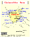
 [Map,177K,InlineGIF]
Mount Baker and the North Cascades Vicinity
-- Modified from: National Park Service Map, 1997
-
 [Map,24K,InlineGIF]
Mount Baker and Mount Shuksan
-- Modified from:
Gardner, et.al, 1995, USGS Open-File Report 95-498
-
 [Map,12K,InlineGIF]
Glaciers of Mount Baker, Washington
-- Modified from:
Hyde and Crandell, 1978, USGS Professional Paper 1022-C, and
USGS Mt.Baker 15' Quadrangle
-
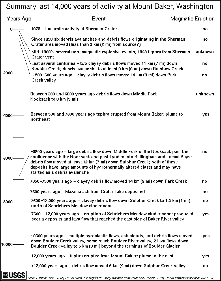
 [Graphic,28K,GIF]
Summary of last 14,000 years of activity at Mount Baker
-- From: USGS Open-File Report 95-498,
Originally modified from: Hyde and Crandell, 1978
|

 [Graphic,28K,GIF]
![[Map,150K,GIF]](https://webarchive.library.unt.edu/eot2008/20081108060054/http://vulcan.wr.usgs.gov/Imgs/Gif/Cascades/Maps/cascade_range.gif)