
USGS/Cascades Volcano Observatory, Vancouver, Washington
Mudflows, Debris Flows, and Lahars
Maps and Graphics, etc.
-
 [Map,44K,GIF]
Mount St. Helens area showing May 18, 1980 devastation
-- From: Tilling, et.al., 1990
-
 [Schematic,13K,GIF]
Stratigraphic section in Harry Gardner Park.
-- L, lithic-rich layer; P, pumice-rich layer.
-- Modified from: Doukas, 1990, USGS Bulletin 1859
-
 [Schematic,25K,GIF]
Generalized stratigraphic section of outcrop at
Muddy River-Pine Creek Fan (near Lahar Viewpoint).
-- Modified from: Doukas, 1990, USGS Bulletin 1859
-
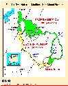 [Map,20K,InlineGIF]
Extent of the Osceola and Electron Mudflows
-- Modified from: Crandell, et.al., 1979
-
 [Map,23K,GIF]
Map showing areas inundated by mudflows from Mount Rainier in the
last 5,600 years
-- Modified from: Sisson, 1995, USGS Open-File Report 95-642
-
 [Map,21K,InlineGIF]
Areas inundated by debris flows from Glacier Peak eruptions
-- From: Mastin and Waitt, 1995, USGS Open-File Report 95-413
Return to:
[Mudflow, Debris Flow, and Lahars Menu] ...

URL for CVO HomePage is:
<http://vulcan.wr.usgs.gov/home.html>
URL for this page is:
<http://vulcan.wr.usgs.gov/Glossary/Lahars/Graphics/framework.html>
If you have questions or comments please contact:
<GS-CVO-WEB@usgs.gov>
09/02/08, Lyn Topinka
 [Schematic,13K,GIF]
 [Schematic,25K,GIF]
 [Map,23K,GIF]