
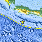
Magnitude 7.7 - SOUTH OF JAVA, INDONESIA
2006 July 17 08:19:28 UTC
Earthquake Details
| Magnitude | 7.7 |
|---|---|
| Date-Time |
= Coordinated Universal Time = local time at epicenter |
| Location | 9.222°S, 107.320°E |
| Depth | 34 km (21.1 miles) set by location program |
| Region | SOUTH OF JAVA, INDONESIA |
| Distances | 230 km (145 miles) NE of Christmas Island 235 km (145 miles) SSW of Tasikmalaya, Java, Indonesia 260 km (160 miles) S of Bandung, Java, Indonesia 355 km (220 miles) SSE of JAKARTA, Java, Indonesia |
| Location Uncertainty | horizontal +/- 7.5 km (4.7 miles); depth fixed by location program |
| Parameters | Nst=234, Nph=234, Dmin=>999 km, Rmss=1.12 sec, Gp= 40°, M-type=teleseismic moment magnitude (Mw), Version=Q |
| Source | USGS NEIC (WDCS-D) |
| Event ID | usqgaf |
- This event has been reviewed by a seismologist.
Did you feel it?
Report shaking and damage at your location. You can also view a map displaying accumulated data from your report and others.
Earthquake Summary

Felt Reports
Four-hundred and three people killed, 452 injured and 26 missing in Ciamis; 62 people killed, 48 injured and 13 missing in Tasikmalaya; 2 people killed and 2 injured in Garut; 151 people killed, 8 injured and 73 missing in Cilacap; 14 people killed, 30 injured and 52 missing in Kebumen; 2 people killed in Banyumas; 3 people killed in Gunung Kidul; 3 people injured in Bantul. At least 1,430 buildings damaged or destroyed, 111 slightly damaged, 1,176 boats destroyed and many roads damaged or destroyed in Jawa Barat. At least 83 buildings damaged and 698 boats damaged or destroyed in Jawa Tengah. Power outages occurred, telephone lines damaged and a tsunami with a wave height of at least 1.8 m occurred at Pangandaran. Tsunamis observed in Cilacap, Kebuman and Tasikmalaya. Felt (IV) at Bandung, Jakarta, Pangandaran and Tasikmalaya; (III) at Cianjur; (II) at Karangkates, Sawahan and Yogyakarta. Also felt at Bantul, Banyumas, Ciamas, Cilacap, Garut, Kebumen, Sukabumi and Surabaya.
Tectonic Summary
The earthquake occurred as a result of thrust-faulting on the boundary between the Australia plate and the Sunda plate. On this part of their mutual boundary, the Australia plate moves north-northeast with respect to the Sunda plate at about 59 mm/year. The Australia plate thrusts beneath the Sunda plate at the Java trench, south of Java, and is subducted to progressively greater depths beneath Java and north of Java. The earthquake occurred on the shallow part of the plate boundary, about 50 km north of the Java trench.
The region of the plate boundary between the Australia plate and Sunda plate is seismically highly active. From preliminary results, it appears that today's earthquake is similar to the earthquake of June 2, 1994, magnitude 7.8, which produced a tsunami that had a maximum run-up height of 13 meters and killed over 200 people. That earthquake occurred south of Java about 600 km east-southeast of today's earthquake, also as a result of thrust faulting on the shallow plate boundary. On August 20, 1977, a magnitude 8.3 normal-fault earthquake occurred within the Australia plate about 1200 km east-southeast of today's earthquake, producing a tsunami that had a maximum run-up height of 15 meters and killed almost 200 people. This year's May 26 devastating Yogyakarta earthquake, magnitude 6.3, occurred at shallow depth within the overriding Sunda plate.
Earthquake Information for Asia
Earthquake Information for Indonesia
 Tsunami Information
- West Coast & Alaska Tsunami Warning Center
- Pacific Tsunami Warning Center
- Recent Tsunamis
- Tsunami Information Links
The earthquake locations and magnitudes cited in these bulletins are very preliminary, and may disagree with the more accurate USGS locations and magnitudes computed using more extensive data sets.


 Historic Moment Tensor Solutions
- Preliminary Earthquake Report
- U.S. Geological Survey, National Earthquake Information Center
World Data Center for Seismology, Denver
