
USGS/Cascades Volcano Observatory, Vancouver, Washington
CVO Monitoring Networks
Maps and Graphics
-
 [Graphic,20K,GIF]
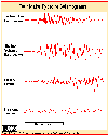
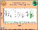
Four major types of seismograms -
Tectonic, Volcanic, Surface, and Tremor
-- From: Brantley and Topinka, 1984,
Earthquake Information Bulletin
-
 [Graphic,28K,GIF]
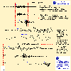
Seismograms of
Volcanic Earthquakes vs. Tectonic Earthquakes,
P, S, and Surface Waves
-- Courtesy of: Noson, et.al., 1988,
Washington State Earthquake Hazards:
Washington State Department of Natural Resources,
Washington Division of Geology and Earth Resources Information
Circular 85, p.9.,
Modified by: Topinka, USGS/CVO, 1997
-
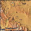
 [Map,30K,InlineGIF]
University of Washington's Pacific Northwest Seismograph Network -
Washington and Oregon
-- Modified from:
University of Washington Geophysics Program, 1998
-
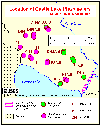
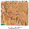
 [Map,21K,GIF]
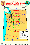
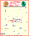
Map of Western United States,
showing locations of volcanoes monitored by CVO
-- Mount Baker to Long Valley
-- Modified from: Iwatsubo and Swanson, 1992,
IN: USGS Bulletin 1966
-
[Map,30K,InlineGIF]
University of Washington's Pacific Northwest Seismograph Network -
Washington and Oregon
-- Modified from:
University of Washington Geophysics Program, 1998
-
[Map,30K,InlineGIF]
University of Washington's Pacific Northwest Seismograph Network -
Washington and Oregon
-- Modified from:
University of Washington Geophysics Program, 1998
-
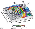
 [Graphic,15K,InlineGIF]
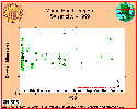
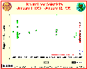
Mount Hood Seismicity, 1999, Time vs. Depth
-- Modified from: University of Washington Geophysics Program
-
 [Graphic,15K,InlineGIF]
Mount Hood Seismicity, 1998, Time vs. Depth
-- Modified from: University of Washington Geophysics Program
-
 [Graphic,15K,InlineGIF]
Mount Hood Seismicity, 1990-1999, Time vs. Depth
-- Modified from: University of Washington Geophysics Program
-
[Map,30K,InlineGIF]
University of Washington's Pacific Northwest Seismograph Network -
Washington and Oregon
-- Modified from:
University of Washington Geophysics Program, 1998
-
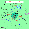
 [Map,13K,InlineGIF]
University of Washington's Pacific Northwest Seismograph Network -
Mount Rainier Vicinity
-- Modified from: University of Washington Geophysics Program,
1997
-
 [Graphic,15K,InlineGIF]
Mount Rainier Seismicity, 1999, Time vs. Depth
-- Modified from: University of Washington Geophysics Program
-
 [Graphic,15K,InlineGIF]
Mount Rainier Seismicity, 1998, Time vs. Depth
-- Modified from: University of Washington Geophysics Program
-
 [Interactive Imagemap]
Location of the Cascades Volcano Observatory and the
Mount St. Helens National Volcanic Monument
-
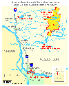
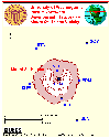
 [Graphic,18K,GIF]
Map showing 1982 Mount St. Helens Monitoring Sites
-- Modified from: E. Iwatsubo, 1996,
and Brantley and Topinka, 1984
-
 [Graphic,20K,GIF]
Map showing 1995 Mount St. Helens Dome Deformation EDM Lines
-- Modified from: E. Iwatsubo, 1996
-
 [Graphic,30K,GIF]
Map showing Mount St. Helens "OuterNet" Flank
Deformation Trilateration Lines
-- Modified from: E. Iwatsubo, 1996
-
[Map,30K,InlineGIF]
University of Washington's Pacific Northwest Seismograph Network -
Washington and Oregon
-- Modified from:
University of Washington Geophysics Program, 1998
-
 [Map,16K,InlineGIF]
University of Washington's Pacific Northwest Seismograph Network -
Mount St. Helens Vicinity
-- Modified from: University of Washington Geophysics Program,
1997
-
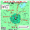
 [Graphic,22K,InlineGIF]
Mount St. Helens Seismicity, 1999, Time vs. Depth
-- Modified from: University of Washington Geophysics Program
-
 [Graphic,30K,InlineGIF]
Mount St. Helens Seismicity, 1998, Time vs. Depth
-- Modified from: University of Washington Geophysics Program
-
 [Graphic,25K,InlineGIF]
Mount St. Helens Seismicity, 1980-1998, Time vs. Depth
-- Modified from: University of Washington Geophysics Program
-
 [Map,30K,InlineGIF]
Location Map, Major Hydrologic Data Collection Sites
surrounding Mount St. Helens
-- Current and Historical
-
 [Map,16K,InlineGIF]
Location Map, Castle Lake Piezometers
-- Modified from: Roeloffs, 1994, USGS WRI-94-4075
-
[Map,30K,InlineGIF]
University of Washington's Pacific Northwest Seismograph Network -
Washington and Oregon
-- Modified from:
University of Washington Geophysics Program, 1998
-
 [Graphic,65K,InlineJPG]
InSAR Image, Three Sisters West Uplift
-- From: Wicks, May 2001
-
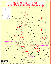
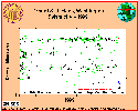
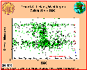
 [Map,42K,InlineGIF]
Yellowstone Continuous GPS Stations, 1999
-- From: Yellowstone Continuous GPS Network Project, 1999
-
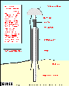 [Graphic,19K,InlineGIF]
Special Yellowstone GPS monument designed for backcountry sites
-- From: Yellowstone Continuous GPS Network Project, 1999
-
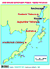 [Map,12K,GIF]
Location Map: Volcano Deformation Project Volcanoes in Alaska
-- Modified from: E. Iwatsubo, 1996
-
 [Map,18K,InlinedGIF]
Augustine Island - USGS/CVO Geodetic Network
-- Modified from: E. Iwatsubo, 1996
-
 [Map,36K,GIF]
Long Valley Tilt Network - 1982
-- Modified from: Dzurisin, Cashman, and Sylvester, 1982
-
 [Map,165K,GIF]
Long Valley Rapid Static GPS Network
--
[Map,186K,JPG]
-
 [Map,220K,InlineGIF]
Long Valley Deformation Monitoring Sites - 1999
-- showing permanent GPS sites, EDM sites, and Dilatometers
Return to:
[Volcano Monitoring Menu]

Copyright and Public Domain:
Use of CVO Material
URL for CVO HomePage is:
<http://vulcan.wr.usgs.gov/home.html>
URL for this page is:
<http://vulcan.wr.usgs.gov/Monitoring/Graphics/framework.html>
If you have questions or comments please contact:
<GS-CVO-WEB@usgs.gov>
11/06/08, Lyn Topinka
 [Graphic,20K,GIF]
 [Graphic,28K,GIF]
 [Map,21K,GIF]
 [Graphic,18K,GIF]
 [Graphic,20K,GIF]
 [Graphic,30K,GIF]
 [Map,12K,GIF]
 [Map,36K,GIF]
 [Map,165K,GIF]