
Northern Rocky Mountain Science Center (NOROCK)
Home | About Us | Science | Product Library | News & Events | Staff | Students | Partners | Contact Us
Northern Rocky Mountain Science Center (NOROCK)
Home | About Us | Science | Product Library | News & Events | Staff | Students | Partners | Contact Us

Research Areas
Glacier Research
Snow and Avalanche Research
Mountain Ecosystems
Landscape Change Photography
Western Mountain Initiative
Product Library
Publications
Presentations
Glacier Recession Animation
Flattop SNOTEL Graphs
Repeat Photo Posters
Info Sheets
Photo Galleries
Repeat Photography
Panoramic Photography
Field Research
CCME Staff
Dan Fagre
Lisa McKeon
Blase Reardon
Lindsey Bengtson
Erich Peitzsch
Chris Miller
Greg Pederson
Contact CCME
CCME
Glacier National Park
West Galcier, MT 59936
About this web page
This web site is a resource for individuals looking for pictures of Glacier National Park and the surrounding area. The set of photographs from which this site was derived provides fascinating insights into National Park Service management philosophy in the 1930s as well as an excellent resource for identifying conditions in Glacier National Park during the same time period. Those interested in historical aspects of the park, vegetation, geomorphology, landscape dynamics, and photography should find these pages useful. Brief descriptions of how these photographs (and photographs in general) are used in the USGS - Glacier Field Station Climate Change Research Program are being added as time permits. Please let us know if you have suggestions for improvement of these pages using the address given at the bottom.
What are these photos?
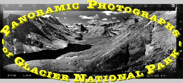
The photograph at the top of this page, from Cosley Ridge (also referred to as Bear Mountain Point), is an example of a panoramic photograph taken from a fire lookout in Glacier National Park. Three photos were taken from each lookout, individual photos covering 120° of the horizon. The azimuth headings for these photographs can be seen along the top. Other details provided along the bottom of each print, from left to right, include - date the photograph was taken, photographers initials (LMM or L Moe), film type (I.R. = infrared, PAN = panchromatic), photo number, photo-point location, and
land-owner at the lookout. A level line was etched into the print and can be seen along the sides at the small notches in the photographs.
These photographs of Glacier National Park were taken in 1935 (a few are from 1937).
While we have been able to locate very little National Park Service documentation as to precisely why the photographs were taken, the US Forest Service began a similar project a few years earlier. This Forest Service project established an efficient fire detection system and is the subject of Albert Arnst’s book, We Climbed the Highest Mountains (1985). Other uses of these photographs suggested by Mr. Arnst include: preliminary location of roads and trails, comparison of changes in vegetation cover types, and visual reference for management and administrative purposes. More than sixty years later, it is quite clear that they have served these purposes well.
How were they taken?
The camera used (an Osborne photo-recording transit) was designed by W. B. Osborne, a Forest Service employee, for fire protection purposes and was custom made. It combined the features of an engineering surveyor’s transit with photographic capabilities. Mr. Osborne also designed other fire detection aids still in use today, such as the Osborne fire finder to help pinpoint forest fire locations. Each camera weighed approximately 75 lbs., often carried on the photographers back up to the lookout. The film was stationary while the lens rotated 120° from right to left for each frame, providing a fixed focal length across the width of the film. Two types of Eastman Kodak film were used: panchromatic (sensitive to light of all colors in the visible spectrum) & infrared (electromagnetic wavelengths longer than the visible spectrum, 0.7mm to ~3mm). Filters used with panchromatic film included a K2 (Wratten No. 8) and #12 deep amber (minus blue member of the cyan-magenta-yellow set of subtractive primaries); while filters used with infrared film included A-red (Wratten No. 25) and F-red (Wratten No. 29). The negatives (and contact prints) are of very high quality film and photography (although the negatives are nitrate based and require careful handling & storage), measuring approximately 5½"x13½". The sun’s position dictated when each photograph could be taken, with the 180°-300° arc photo taken about 9am, the 300°-60° arc photo about noon, and the 60°-180° arc photo about 3pm. The camera was positioned along the catwalk of the lookout when possible, but it was sometimes necessary to climb towers, roofs, and trees to take photographs.
Carrying over 75lbs of camera plus personal gear up to fire lookouts throughout the park was a demanding task. Mules can be seen in several of the photographs and were used to help the photographer transport equipment. The hundreds of photographs taken by Mr. Moe provide excellent documentation of what National Park Service sites looked like in the 1930s. The National Park Service announced the completion of this project in a newsletter excerpted below.
Chief Forester Coffman announces completion of a 4-year project for obtaining panoramic photographs from the 200 existing and proposed forest fire lookouts throughout
the entire Federal Park System.
The photographic work, done by Junior Forester Moe, entailed many hardships not only in packing the necessary equipment weighing upwards of 100 pounds to lookout points, but also in climbing trees, poles, temporary towers, or roofs of lookouts with the equipment and facing the extreme winds that occur so frequently at high elevations.Park Service Bulletin, June 1938, pg. 6
Some more technical details.…
The images available at this web site were scanned from the original prints (described above). As these prints are more than 60 years old, there were often imperfections and faded regions. No attempt was made to modify these characteristics in the digital versions. They were originally scanned at 300 dots per inch, and then reformatted to a more suitable data size for display on this web site (72 dpi).
How are they used today?
There are many uses for these photographs still today. Several examples are given below.


For more information on what a glacier is and how they work, visit the National Snow & Ice Data Center (NSIDC)
educational web page on glaciers and Rice University’s web page GLACIER on Antarctica and the role of glaciers in global systems.
How can I interpret them?
By working to explain what, why, how, & where we see things (or don't see them) we can learn a great deal about the subjects of these photographs.

Arnst, Albert. 1985. We Climbed the Highest Mountains. Portland, OR: Fernhopper Press.
This excellent reference provided technical details of the camera, film, and similar US Forest projects.
Kresek, Ray. 1984. Fire Lookouts of the Northwest. Fairfield, WA: Ye Galleon Press.
Provides details on lookouts and their locations in the Glacier National Park area and throughout the northwest.
Acknowledgements:
Photographs provided courtesy of Glacier National Park Archives, West Glacier, MT 59936. Technical assistance provided by Kevin Laurent, USGS Multimedia Science Support Team.
Contacts
Content Information Contact: Dan Fagre, email: dan_fagre@usgs.gov, telephone: 406.888.7922,
mail: Glacier Field Station, Glacier National Park, West Glacier, MT 59936.
Prepared by: Fritz Klasner, email: fritz_klasner@nps.gov.

