WaterWatch -- Current Water Resources Conditions
| |||
|
|
WaterWatch -- Current water resources conditions
Map of real-time streamflow compared to historical streamflow for the day of the year (United States)
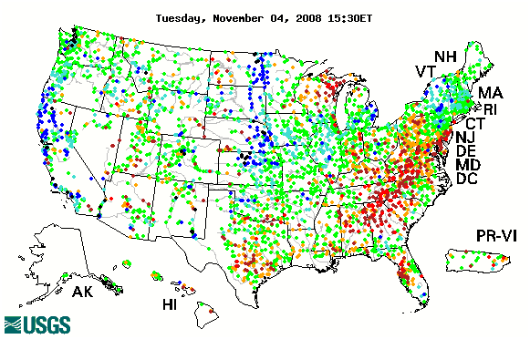
The "Real-time streamflow" map tracks short-term changes (over several hours) in rivers and streams. Although the general appearance of the map changes very little from one hour to the next, individual sites may change rapidly in response to major rain events or to reservoir releases.
The map depicts streamflow conditions as computed at USGS streamgages. The colors represent real-time streamflow compared to percentiles of historical daily streamflow for the day of the year.
This map represents conditions relative to those that have historically occurred at this time of year. Only streamgages having at least 30 years of record are used.
States containing no dots indicate locations where flow data for the current day are temporarily unavailable. During winter months, some states (or parts of states) may have fewer dots than at other times of the year due to ice effects.
The data used to produce this map are provisional and have not been reviewed or edited. They may be subject to significant change.
Alternative data formats of this map in postscript, Google Earth KML, Google Maps, or GIS coverage or shapefile are available.

![]() U.S. Department of the Interior |
U.S. Geological Survey
U.S. Department of the Interior |
U.S. Geological Survey
URL: http://water.usgs.gov/waterwatch
Page Contact Information: Contact USGS
Page Last Modified: Thursday, November 6, 2008
