Glacier Monitoring Research
|
Monitoring and Assessing Glacier Changes and Their Associated Hydrologic and Ecologic Effects in Glacier National Park
|
|
|
 |
|
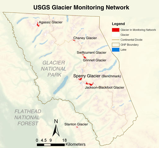
Secondary Glacier Network:
Chaney, Grinnell, Stanton, Agassiz, Swiftcurrent, Jackson-Blackfoot Glaciers
|
|
The Secondary Glacier Network includes six glaciers that form a north-south transect of approx. 60 km through the region, with Sperry Glacier just south of center. While these glaciers will be monitored less frequently than the benchmark glacier, Sperry, this network will provide data about the variability of processes that control glacier mass and area within the region.
|
Secondary Glacier Network Sites
• Chaney (2200 - 2350 m., 48o51’00”/ 113o49’40”)
• Grinnell (1980- 2200 m., 48o45’10”/ 113o43’30”)
• Stanton (2350- 2600 m., 48o20’20”/ 113o46’20”)
• Agassiz (2350- 2560 m., 48o56’10”/ 114o09’45”)
• Swiftcurrent (2200 - 2330 m., 48o46’05”/ 113o44’43”)
• Jackson-Blackfoot (2200- 2600 m., 48o20’20”/ 113o40’05”)
|
|
Proposed measurements over the next 5 seasons (2005 – 2010):
• GPS mapping of margins/ termini
• Continued repeat photography
• Streamflow measurements below Grinnell Glacier and Upper Grinnell Lake.
• Surface mass balance measurements
• Remote sensing
|
 |
Chaney Glacier
|
|
Topographic characteristics: Chaney glacier is contained in a basin which is hydrologically well defined with one main outflow stream. It has a good elevation range which extends from the cirque floor to, in one section, the surrounding ridge top. This elevation range is a common characteristic for glaciers in the study area. Chaney glacier is located on the E side of the Continental Divide and is NE facing. A small, pro-glacial lake has formed near the center of the glacier in recent years; calving into the lake complicates measurements, though it is nowhere near the scale of the calving into Grinnell.
Accessibility: Chaney glacier requires a day and a half of trail and cross-country travel to reach during summer through early autumn, with longer and more difficult access in early spring and winter. Glacier travel is fairly straightforward with a few crevasses to negotiate.
Previous research/monitoring: Remote sensing and repeat photography.
|
Grinnell Glacier
 Topographic characteristics: Grinnell glacier sits in a basin which is hydrologicaly well defined and contains a stream gauge below the outlet of the terminus glacial lake (this gauge has just been reactivated in 7/04 from its past life of 1958 – 1971). Grinnell is located on the E side of the Continental Divide and is NNE facing, and is centrally located within the Network. Some problems with Grinnell’s topography are that the terminus often calves off into the lake, it is a fairly low angle glacier, it is highly crevassed and time consuming to negotiate, and rock and snowfall are fairly common occurrences on the upper end of the glacier. Topographic characteristics: Grinnell glacier sits in a basin which is hydrologicaly well defined and contains a stream gauge below the outlet of the terminus glacial lake (this gauge has just been reactivated in 7/04 from its past life of 1958 – 1971). Grinnell is located on the E side of the Continental Divide and is NNE facing, and is centrally located within the Network. Some problems with Grinnell’s topography are that the terminus often calves off into the lake, it is a fairly low angle glacier, it is highly crevassed and time consuming to negotiate, and rock and snowfall are fairly common occurrences on the upper end of the glacier.
Accessibility: Grinnell glacier is easily accessible in late spring through early autumn, somewhat accessible in early spring, but difficult to access in winter.
Previous research/monitoring: There has been a history of monitoring on Grinnell glacier including ablation stakes, radar work, remote sensing, stream gauging equipment, GPS recordings of glacier margin, and repeat photography. See Johnson, 1980.
Stanton Glacier
|
|
Topographic characteristics: Stanton glacier is a north-facing glacier located at the southernmost end of the study area and outside the park. It has a good elevational gradient and is in a hydrologically well defined basin.
Accessibility: A good climb with a path most of the way in late spring through early autumn.
Previous research/monitoring: Remote sensing.
|
 Agassiz Glacier Agassiz Glacier
Topographic characteristics: Agassiz glacier is located in a cirque basin which is hydrologically well defined with one main outflow stream. It is located west of the Continental Divide and is one of the northern most glaciers in the study area and faces NNE.
Accessibility: Agassiz glacier takes two days of trail and cross-country travel to reach during summer through early autumn; a shortcut up Pocket Creek shortens travel distance in the winter, though it still requires two days of travel.
Previous research/monitoring: Tree ring data collection to determine glacial recession rates, remote sensing, and repeat photography.
 Swiftcurrent Glacier Swiftcurrent Glacier
Topographic characteristics: Swiftcurrent glacier is located in a NE facing basin just E of the Continental Divide. It is fairly small in size compared to other glaciers considered for the Secondary Network but is contained in a hydrologically well defined basin.
Accessibility: Swiftcurrent glacier is easily accessed from spring through autumn in a day’s hike. There is a cabin within a mile of the glacier from which work can be based. The glacial basin is easily accessed from the ridge above the glacier.
|