click on thumbnail for "user-friendly" medium-size image ...
medium-size images are around 100 K and best for web viewing ...
large-size images are 4-8 M, scanned images, no logo, 300 dpi, 8x10 to 9x12 size, and good for printing and publication ...
Lassen82_lassen_peak_and_kings_creek_10-82.jpg
Lassen Peak, California, and Kings Creek Meadows, Lassen Volcanic National Park.
USGS Photograph taken in October 1982 by Lyn Topinka
[medium size] ...
[large size] ...
[TIF Format, 24 M]
Sisters77_south_sister_lava_flows_09-77.jpg Aerial view of the south flank of South Sister composite volcano showing numerous blocky lava flows erupted about 2,000 years ago. Early eruptions formed Rock Mesa (just above center, far left), a broad flat flow emplaced on nearly level ground. Subsequent eruptions formed a line of lava domes and flows that extend from Sparks Lake meadow (lower right) to Green Lakes (just above center, far right). Several small lava domes were also formed on the northeast flank, out of view. Cratered cone in lower left is Talapus Butte, a basaltic scoria cone.
USGS Photograph taken in September 1977 by C.Dan Miller.
[medium size] ...
[large size] ...
[TIF Format, 25 M]
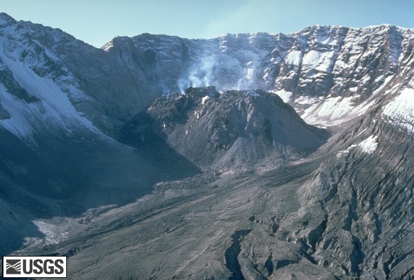
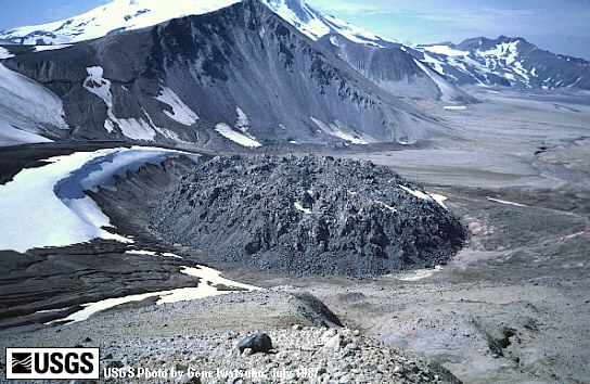
MSH84_st_helens_crater_dome_from_NNW_09-13-84.jpg Since December 1980, eruptions of Mount St. Helens have added material to a dacitic lava dome with the crater, as seen here in this 1984 view from the north-northwest.
USGS Photograph taken on September 13, 1984, by Lyn Topinka.
[medium size] ...
[large size]
 Use of CVO Material and Copyright Information


 MORE -- Mount St. Helens Lava Dome Images
 [Image,64K,JPG]
 [Image,50K,JPG]