Q & A's | Fun Facts | Cool Stuff to See |Cool Links Cool Stuff to Do | Questions? Ask Us! | Glossary Search |TerraWeb for Kids Home
|
| Q & A's | |
| Click a question to read the answer! |
| What is Remote Sensing? | |
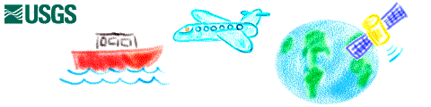
| Remote Sensing is the gathering of information about the Earth from a distance. Information can be collected about the land using special cameras and instruments located:
| Information can be collected about the seafloor using a sonarsystem towed on a cable behind a ship. Instead of taking a picture using light to see, sonar*"sees" using sound. By measuring the amount of time it takes sound to travel from the ship to the seafloor and back to the ship, and how much the sounds bounces back, we can make a picture of the seafloor. Pictures taken by special cameras on airplanes and satellites and by sonar systems on shipsare called remotely sensed images*. These images are often collected as digital files. This allows us to use computers to improve and analyze the images. |
![[satellite drawing]](satellite.GIF) |
|
| What is Remote Sensing used for? | |
![[ship drawing]](boat.gif) | Specific jobs that can be helped with remote sensing* pictures:
|
| The special cameras are used to collect remotely sensed pictures of the Earth, and used to help us "sense" things about the Earth. Some examples are:
|
|
[ TOP of Page] [ TOP of Q & A's ]
![]()
|
U.S. Department of the Interior |
U.S. Geological Survey |
Jobs
Home | Search | Disclaimers & Privacy Web Rings Send comments to webman@TerraWeb.wr.usgs.gov URL: Last Modified: Thu Oct 31 15:08:17 MST 2002 |