
 Feeds & Data
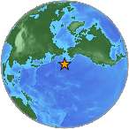
Magnitude 4.2 - ANDREANOF ISLANDS, ALEUTIAN IS., ALASKA
2008 November 01 09:22:48 UTC
Earthquake Details
| Magnitude | 4.2 |
|---|---|
| Date-Time |
|
| Location | 51.502°N, 174.395°W |
| Depth | 38.6 km (24.0 miles) |
| Region | ANDREANOF ISLANDS, ALEUTIAN IS., ALASKA |
| Distances |
|
| Location Uncertainty | horizontal +/- 23.5 km (14.6 miles); depth +/- 11.7 km (7.3 miles) |
| Parameters | NST= 29, Nph= 29, Dmin=132.6 km, Rmss=1 sec, Gp=209°, M-type=body magnitude (Mb), Version=6 |
| Source |
|
| Event ID | us2008ywa2 |
- This event has been reviewed by a seismologist.
- Did you feel it? Report shaking and damage at your location. You can also view a map displaying accumulated data from your report and others.
Earthquake Maps
Earthquake Location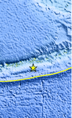
Location Maps
Historical Seismicity
Seismic Hazard Map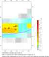
EQ Density Map
Google Map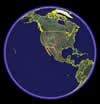
Google Earth KML
(Requires Google Earth)- Did you feel it? Report shaking and damage at your location. You can also view a map displaying accumulated data from your report and others.
Scientific & Technical Information
 Historic Moment Tensor Solutions
Additional Information, News Reports
- Preliminary Earthquake Report
- U.S. Geological Survey, National Earthquake Information Center:
World Data Center for Seismology, Denver
