
 Feeds & Data
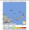
Magnitude 6.0 - BISMARCK SEA
2008 November 01 01:13:10 UTC
Earthquake Details
| Magnitude | 6.0 |
|---|---|
| Date-Time |
|
| Location | 3.395°S, 148.543°E |
| Depth | 10 km (6.2 miles) set by location program |
| Region | BISMARCK SEA |
| Distances | 210 km (130 miles) SE of Lorengau, Manus Island, PNG 265 km (165 miles) WSW of Kavieng, New Ireland, PNG 685 km (425 miles) NNE of PORT MORESBY, Papua New Guinea 2700 km (1680 miles) N of BRISBANE, Queensland, Australia |
| Location Uncertainty | horizontal +/- 9.1 km (5.7 miles); depth fixed by location program |
| Parameters | NST= 64, Nph= 64, Dmin=682.4 km, Rmss=1.42 sec, Gp= 58°, M-type=regional moment magnitude (Mw), Version=6 |
| Source |
|
| Event ID | us2008ywae |
- This event has been reviewed by a seismologist.
- Did you feel it? Report shaking and damage at your location. You can also view a map displaying accumulated data from your report and others.
Earthquake Summary


Earthquake Information for Australia
 Tsunami Information
- NOAA West Coast & Alaska Tsunami Warning Center
- NOAA Pacific Tsunami Warning Center
- Tsunami Information Links
The earthquake locations and magnitudes cited in these NOAA tsunami bulletins are very preliminary and may be superceded by USGS locations and magnitudes computed using more extensive data sets.
Earthquake Maps


Scientific & Technical Information

- Preliminary Earthquake Report
- U.S. Geological Survey, National Earthquake Information Center:
World Data Center for Seismology, Denver
