Lower Columbia: from Bonneville to Pacific Ocean
Willamette Ecosystem Marketplace
Farmers, business leaders, scientists, city officials and environmental advocates formed the Willamette Partnership to pursue new approaches for restoring the ecological health in the Willamette Basin. The Willamette Partnership’s innovative program for improving water quality in the Willamette River is called the Willamette Ecosystem Marketplace. One of the goals of the Ecosystem Marketplace is to establish trading mechanisms involving conservation credits that would expand the use of natural and sustainable remediation strategies which offer greater opportunities to heal the basin. It gives point source polluters the chance to mitigate their high-temperature discharges by buying conservation credits that can be used to address non-point sources of pollution. For example, rather than building concrete and steel cooling structures to lower the temperature of the discharge waters, a treatment plant could pay farmers to allow streams to meander in their floodplains or to plant trees along streamsides, which would lower the water temperature through natural processes.
In 2006, the Willamette Partnership was selected by the Environmental Protection Agency as a grant recipient in its Targeted Watershed Grants program. The EPA awards these grants to organizations promoting watershed health through innovative programs such as the Willamette Ecosystem Marketplace.
The cap for this temperature-based trading market will be established by the Willamette Basin Temperature Total Maximum Daily Load, or TMDL. The Willamette Partnership is working closely with the Oregon Department of Environmental Quality and the EPA to align the TMDL implementation requirements of pollutant dischargers identified in the TMDL with the objectives of the Willamette Ecosystem Marketplace.
Learn more about the Willamette Ecosystem Marketplace
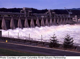
Lower Columbia River Estuary Partnership
The Lower Columbia River Estuary Partnership
 is one of 28 collaborations that make up EPA’s National Estuary Program, which is designed to protect America’s nationally significant estuaries for their natural, economic and aesthetic values. The estuary programs create and implement Comprehensive Conservation and Management Plans (CCMPs), which address all aspects of environmental protection for an estuary, including issues such as water quality, habitat, living resources and land use.
The Estuary Partnership is responsible for implementing the Lower Columbia River’s Comprehensive Conservation and Management Plan. The plan consists of 43 distinct actions that address three overarching goals:
is one of 28 collaborations that make up EPA’s National Estuary Program, which is designed to protect America’s nationally significant estuaries for their natural, economic and aesthetic values. The estuary programs create and implement Comprehensive Conservation and Management Plans (CCMPs), which address all aspects of environmental protection for an estuary, including issues such as water quality, habitat, living resources and land use.
The Estuary Partnership is responsible for implementing the Lower Columbia River’s Comprehensive Conservation and Management Plan. The plan consists of 43 distinct actions that address three overarching goals:
- On-the-ground improvements for habitat and land use
- Heightened education and information and government coordination
- Reduction of toxic and conventional pollutants
Highlights of the Lower Columbia River Estuary Partnership include:
- Over 100 habitat restoration projects (28 of them directly funded by the Estuary Partnership) are realizing over 10,000 acres of restoration.
- Since January 2001, the Estuary Partnership has reached 80,680 students through science programs in the classroom and in the field.
- Citizens planted 5,200 trees and shrubs in 2007. Since 2000, citizens have planted more than 21,900 native plants and removed more than 100 truckloads of invasive plants at 18 habitat restoration sites.
- The Estuary Partnership coordinates the Lower Columbia River Water Trail, which covers the lower 146-mile stretch of the lower Columbia River.
- A long-term water quality monitoring program has been instituted that will allow the Partnership to assess its progress and the impacts of pollutants on public health.
- Focused awareness on personal care products and other emerging contaminants which adversely affect water quality and aquatic life in the Lower Columbia River.
- The Estuary Partnership released "Lower Columbia River and Estuary Ecosystem Monitoring: Water Quality and Salmon Sampling Report". This details the results of the Partnership's juvenile salmon and water quality monitoring efforts and compares the two datasets to help determine which toxics are contributing to declines in salmon populations and how juvenile salmon exposure to those contaminants can be reduced.
- The Estuary Partnership convened a workshop to identify bathymetry data gaps in the lower Columbia River.
- The Estuary Partnership and USGS sponsored the Columbia River Summit on Toxic Contaminant Reduction in January 2008 to focus on reducing the level of toxic contaminants entering the Columbia River system. Over 100 business leaders and public sector officials attended the Summit and discussed next steps for toxic reduction and monitoring of the lower Columbia River and estuary.
Estuary Partnership Targeted Watershed Grant
In 2003, the Estuary Partnership received a Targeted Watershed Grant from EPA. The grant was used to fund several restoration activities:
- Remove an additional 22 acres of invasive reed canary grass at Smith and Bybee lakes Wildlife Area, plant native species, and restore corridor linkages between core areas of habitat.
- Undertake major restoration work at Grays Bay Area to permanently protect 880 acres, restore floodplain connectivity to 440 acres of tidal backwater, riparian, and forested wetland habitat and restore over 300 acres of potential salmonid rearing habitat.
- Re-establish a functioning wetland at Mirror Lake by removing invasive reed canary grass and blackberry, and replanting native species and replacing culverts on approximately 200 acres.
- Reconnect hydrology by removing barriers to species migration by employing grazing management practices and replanting native vegetation protecting over 300 acres of wetlands in the Scappoose Bay Watershed.
Region 10 Coastal Environmental Monitoring and Assessment Program
Environmental Monitoring and Assessment Program (EMAP) uses a probability-based type of sample design to assess the overall condition of a specific geographic area. In EPA Region 10, the Western Pilot EMAP study was a collaborative effort of federal and state agencies. In 1999 the small estuaries of Oregon and Washington were sampled and in 2000 the larger estuaries of the Columbia River and Puget Sound were the subject of EMAP evaluation. EMAP testing includes: water quality, biological community, sediment chemistry, sediment toxicity, and fish tissue chemistry. Overall, very little of the estuarine area of Oregon and Washington was found to be in “poor” condition for any EMAP indicator including either water quality or sediment indicators. |  | |
A slightly higher percentage of the estuarine area of Oregon and Washington were in “poor” condition for biological indicators (e.g., Non-Indigenous Species (NIS) and chemicals in fish tissue). However, results for specific geographic areas indicated areas of concern. Hood Canal (Washington) showed low bottom dissolved oxygen and all sites with fish tissue levels exceeding the Toxic tissue Screening Criteria (TSC) for mercury were in the Columbia River estuary.
The Toxic tissue Screening Criteria (TSC) are tissue residue levels that, when exceeded, may be harmful to fish. The TSC have been evaluated for arsenic, cadmium, DDT, lead, mercury, selenium and zinc. Sites with fish tissue levels exceeding TSC for DDT were mostly in the Columbia River estuary. Finally, the coastal estuaries and the Columbia River were much more invaded by NIS than Puget Sound, with 12% - 25% of the area in the highly invaded category.
More information: Ecological Condition of the Columbia River Estuary (1999-2000) (60 pp. 1.7MB)
Columbia River Channel Deepening Project Update
 The Oregon Department of Environmental Quality (DEQ) issued the U.S. Army Corps of Engineers (Corps) a 401 permit to deepen the Columbia River federal navigation channel in June of 2003. The project will deepen the Columbia River navigation channel between River Mile (RM) 3 and RM 106.5 from a depth of 40 feet to a depth of 43 feet to allow continued navigation access and the economic benefits of waterborne commerce along the length of the shipping channel. A total of 14.5 million cubic yards of sand will be removed from the Columbia River federal navigation channel.
The current project 401 permit will expire in June of 2008. DEQ anticipates that the Corps will begin the 401 renewal process for this project early in 2007. The Corps does not currently have an anticipated date of completion for this project.
Dredging began late May of 2005. In 2005, dredging took place at RM 3 to 20 from Astoria to Rice Island, and RM 95 to 105 near Hayden Island in Portland. In 2006 the Corps dredged RM 21 to 35 from Rice Island to Welsh Island, and RM 88 to 95 to the mouth of Multnomah Channel.
The current 401 permit requires the Corps to perform environmental monitoring for turbidity and dissolved oxygen during dredging and disposal, toxic sampling and analysis of sediments prior to dredging, use of best management practices, restricts work outside of the 600-foot navigation channel to the Oregon Department of Fish and Wildlife in-water work window (Nov to Feb), specifies in-water and upland disposal requirements, requires on-line reporting of environmental data, and requires an Adaptive Management Team to meet on a regular basis to determine project impacts on water quality, habitat, fisheries, and crab populations. The Adaptive Management Team meets on a quarterly basis and is composed of representatives from the following agencies: Corps, DEQ, Washington Department of Ecology, NOAA Fisheries, Port of Portland, US Fish and Wildlife, and Oregon Department of Land Conservation and Development.
Portland Watershed Management Plan
In 2005 with the passage of the Watershed Management Plan the City of Portland decided on a bold approach to improving watershed health. The Watershed Plan describes the approach that will be used to evaluate conditions in the City's urban watersheds and implement projects to improve watershed health. Many groups are employed to implement the plan including several city bureaus and citizens’ groups with the common goal to protect Portland's natural resources, restore critical ecosystems, and implement stormwater solutions that integrate the urban area with the natural environment.
The Oregon Department of Environmental Quality (DEQ) issued the U.S. Army Corps of Engineers (Corps) a 401 permit to deepen the Columbia River federal navigation channel in June of 2003. The project will deepen the Columbia River navigation channel between River Mile (RM) 3 and RM 106.5 from a depth of 40 feet to a depth of 43 feet to allow continued navigation access and the economic benefits of waterborne commerce along the length of the shipping channel. A total of 14.5 million cubic yards of sand will be removed from the Columbia River federal navigation channel.
The current project 401 permit will expire in June of 2008. DEQ anticipates that the Corps will begin the 401 renewal process for this project early in 2007. The Corps does not currently have an anticipated date of completion for this project.
Dredging began late May of 2005. In 2005, dredging took place at RM 3 to 20 from Astoria to Rice Island, and RM 95 to 105 near Hayden Island in Portland. In 2006 the Corps dredged RM 21 to 35 from Rice Island to Welsh Island, and RM 88 to 95 to the mouth of Multnomah Channel.
The current 401 permit requires the Corps to perform environmental monitoring for turbidity and dissolved oxygen during dredging and disposal, toxic sampling and analysis of sediments prior to dredging, use of best management practices, restricts work outside of the 600-foot navigation channel to the Oregon Department of Fish and Wildlife in-water work window (Nov to Feb), specifies in-water and upland disposal requirements, requires on-line reporting of environmental data, and requires an Adaptive Management Team to meet on a regular basis to determine project impacts on water quality, habitat, fisheries, and crab populations. The Adaptive Management Team meets on a quarterly basis and is composed of representatives from the following agencies: Corps, DEQ, Washington Department of Ecology, NOAA Fisheries, Port of Portland, US Fish and Wildlife, and Oregon Department of Land Conservation and Development.
Portland Watershed Management Plan
In 2005 with the passage of the Watershed Management Plan the City of Portland decided on a bold approach to improving watershed health. The Watershed Plan describes the approach that will be used to evaluate conditions in the City's urban watersheds and implement projects to improve watershed health. Many groups are employed to implement the plan including several city bureaus and citizens’ groups with the common goal to protect Portland's natural resources, restore critical ecosystems, and implement stormwater solutions that integrate the urban area with the natural environment.
 | | An overarching theme of the Plan is to achieve improved watershed health through watershed-friendly development, installation of new stormwater infrastructure and the City's repair and maintenance of existing infrastructure in new ways that will improve watershed health. The Plan presents the science behind the need for these approaches and a management system to track City progress toward well-defined watershed health goals.
Another major component of the Plan is an integrated City response to local, state and federal environmental requirements. Instead of the traditional mandate-by-mandate approach, our regulatory responses will be based on the root causes of problems and not just symptoms. This will provide Portland with the means to solve current environmental problems without creating future ones. |
2005 Portland Watershed Management Plan
 Portland Innovative Wet Weather Programs
Municipal stormwater facilities can be overburdened during heavy rainfall, requiring the release of overflow sewage into rivers. EPA awarded the City of Portland a community-specific State and Tribal Assistance Grant (STAG) for improving its sewer system. Working with EPA, the City of Portland Bureau of Environmental Services developed a plan for reducing stormwater run-off and thus reducing Combined Sewer Overflows (CSO) that would otherwise be released into the Willamette River, a major tributary of the Columbia River. Learn more about the City of Portland Innovative Wet Weather Programs
Portland Innovative Wet Weather Programs
Municipal stormwater facilities can be overburdened during heavy rainfall, requiring the release of overflow sewage into rivers. EPA awarded the City of Portland a community-specific State and Tribal Assistance Grant (STAG) for improving its sewer system. Working with EPA, the City of Portland Bureau of Environmental Services developed a plan for reducing stormwater run-off and thus reducing Combined Sewer Overflows (CSO) that would otherwise be released into the Willamette River, a major tributary of the Columbia River. Learn more about the City of Portland Innovative Wet Weather Programs
 Superfund in the Lower Columbia
Site Assessment
The EPA Site Assessment Program is responsible for locating contaminated sites and determining which sites become Superfund national priorities. After a site is identified as contributing (or having the potential to contribute) contaminants to the environment, one of many cleanup programs can be initiated (emergency response, removal, or remedial actions).
Because the Columbia River Basin is a large river system that covers a wide area and measures nearly 1,000 miles in length, site assessments will take place in phases. A site assessment was begun in the Lower Columbia River in fall 2006. Eventually all three sections will be considered.
To learn more about cleanup efforts in Oregon and Washington:
Oregon's Site Assessment Program
Superfund in the Lower Columbia
Site Assessment
The EPA Site Assessment Program is responsible for locating contaminated sites and determining which sites become Superfund national priorities. After a site is identified as contributing (or having the potential to contribute) contaminants to the environment, one of many cleanup programs can be initiated (emergency response, removal, or remedial actions).
Because the Columbia River Basin is a large river system that covers a wide area and measures nearly 1,000 miles in length, site assessments will take place in phases. A site assessment was begun in the Lower Columbia River in fall 2006. Eventually all three sections will be considered.
To learn more about cleanup efforts in Oregon and Washington:
Oregon's Site Assessment Program
 Oregon's Environmental Cleanup Program
 Washington's Site Assessment Program
 Washington's Toxic Cleanup Program
 Portland Harbor
 was added to the EPA National Priorities List in December 2000. The Superfund site's initial study area is located along the Willamette River from downtown Portland, Oregon to the Columbia River. Sediment in the study area has been found to contain PCBs, dioxin / furans, mercury, pesticides and herbicides.
Two major rounds of sampling have been completed to characterize the physical system, surface and subsurface sediment chemistry, sediment toxicity, surface water quality, and groundwater quality. The State of Oregon DEQ is working with upland property owners to identify and control ongoing sources of contamination to the river. A Round 2 comprehensive site characterization summary report was completed and submitted in spring of 2007. The report provides an evaluation of sampling results, identifies data gaps and areas of potential concern for possible future cleanup.
Three areas in the river have been identified for early cleanup actions. A tar body in sediment adjacent to the GASCO facility was excavated and disposed of at a permitted off-site disposal facility in the fall of 2005. An action memo was signed in summer of 2006 requiring cleanup of the Port of Portland Terminal 4, slips 1 and 3, and design is underway. A work plan for investigation of the sediment adjacent to the Arkema facility is being prepared to address an area with elevated concentrations of several contaminants, including DDT.
Reynolds Metals
The Reynolds Metals site near Troutdale, Oregon, near the south shore of the Columbia River was added to EPA's National Priorities List in 1994 because soil and groundwater were contaminated with fluoride, polynuclear aromatic hydrocarbons (PAHs), polychlorinated biphenyls (PCBs) and other hazardous substances. EPA issued an interim cleanup decision for the site in 2002 that required cleanup of three contaminated sites - north landfill, south landfill and Company Lake - which were sources of contamination to site groundwater and begin the cleanup of fluoride-contaminated groundwater. Cleanup of the source areas was completed in 2005, and the groundwater system is operational. EPA issued a final cleanup decision in September 2006 based on a Proposed Plan that was issued in August 2006. The Proposed Plan indicated that the cleanup of soils is complete, but the groundwater system will need to operate for 10 to 15 years to achieve drinking water standards.
Fish Consumption and Contaminant Survey
In 1991, EPA entered into a two-part agreement with the Columbia River Inter-Tribal Fish Commission (CRITFC)
Portland Harbor
Portland Harbor was added to the EPA National Priorities List in December 2000. The Superfund site's initial study area is located along the Willamette River from downtown Portland, Oregon to the Columbia River. Sediment in the study area has been found to contain PCBs, dioxin / furans, mercury, pesticides and herbicides.
Two major rounds of sampling have been completed to characterize the physical system, surface and subsurface sediment chemistry, sediment toxicity, surface water quality, and groundwater quality. The State of Oregon DEQ is working with upland property owners to identify and control ongoing sources of contamination to the river. A Round 2 comprehensive site characterization summary report was completed and submitted in spring of 2007. The report provides an evaluation of sampling results, identifies data gaps and areas of potential concern for possible future cleanup.
Three areas in the river have been identified for early cleanup actions. A tar body in sediment adjacent to the GASCO facility was excavated and disposed of at a permitted off-site disposal facility in the fall of 2005. An action memo was signed in summer of 2006 requiring cleanup of the Port of Portland Terminal 4, slips 1 and 3, and design is underway. A work plan for investigation of the sediment adjacent to the Arkema facility is being prepared to address an area with elevated concentrations of several contaminants, including DDT.
Reynolds Metals
The Reynolds Metals site near Troutdale, Oregon, near the south shore of the Columbia River was added to EPA's National Priorities List in 1994 because soil and groundwater were contaminated with fluoride, polynuclear aromatic hydrocarbons (PAHs), polychlorinated biphenyls (PCBs) and other hazardous substances. EPA issued an interim cleanup decision for the site in 2002 that required cleanup of three contaminated sites - north landfill, south landfill and Company Lake - which were sources of contamination to site groundwater and begin the cleanup of fluoride-contaminated groundwater. Cleanup of the source areas was completed in 2005, and the groundwater system is operational. EPA issued a final cleanup decision in September 2006 based on a Proposed Plan that was issued in August 2006. The Proposed Plan indicated that the cleanup of soils is complete, but the groundwater system will need to operate for 10 to 15 years to achieve drinking water standards.
Fish Consumption and Contaminant Survey
In 1991, EPA entered into a two-part agreement with the Columbia River Inter-Tribal Fish Commission (CRITFC)
 and its four member tribes:
The Confederated Tribes of the Warm Springs Reservation of Oregon
and its four member tribes:
The Confederated Tribes of the Warm Springs Reservation of Oregon
 The Confederated Tribes and Bands of the Yakama Nation
 The Confederated Tribes of the Umatilla Indian Reservation
 The Nez Perce Tribe
 to better understand the relationship of tribal fishing practices and the likelihood of tribal exposure to environmental contaminants through fish consumption. In the first phase of this agreement, EPA provided a grant to CRITFC for a fish consumption survey.
The Fish Consumption Survey
 was completed in 1994 and documented the amount and types of fish consumed by the four Columbia River Treaty Tribes and demonstrated that the CRITFC tribal members consume higher amounts of fish per capita than the average U.S. citizen. EPA used these results in the revisions to methodology for developing water quality criteria as well as hazardous waste site remediation specifically to derive tribal subsistence ingestion rates.
The second part of the agreement with CRITFC was to complete a survey of contaminants in fish tissue. Fish tissue samples were collected from those portions of the Columbia River Basin where the four CRITFC member tribes fish in Washington, Oregon, and Idaho. The EPA Columbia River Basin Fish Contaminant Survey was completed in July 2002. Results showed the presence of residues of 92 priority pollutants in fish that are consumed by CRITFC tribal members and other people in the Columbia River Basin. Chemicals measured in Columbia River fish included PCBs, dioxins, furans, arsenic, mercury, and DDE, a breakdown product of DDT.
Total Maximum Daily Loads (TMDLs) for the Lower Columbia
In order to meet Water Quality Standards there are TMDLs for the lower section of the river basin:
- Sandy River Basin Temperature, Bacteria and Dissolved Oxygen
- Willamette River Mainstem Mercury, Temperature and Bacteria
- Columbia Slough Chlorophyll a, Dissolved Oxygen, pH, Phosphorus, Bacteria, DDE/DDT, PCBs, Pb, Dieldrin and 2,3,7,8 TCDD
- Total Dissolved Gas in the Lower Columbia
- North Coast Subbasins Temperature and Bacteria
Learn more about TMDLs in the Columbia Basin.