
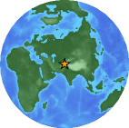
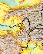
Magnitude 5.9 Afghanistan-Tajikistan Border Region
1998 February 04 14:33:21 UTC
Preliminary Earthquake Report
U.S. Geological Survey, National Earthquake Information Center
World Data Center for Seismology, Denver
|
Magnitude | 5.9 | |
| Date-Time | 1998 02 04 14:33:21 UTC | ||
| Location | 37.07N 70.08E | ||
| Depth | 33.0 kilometers | ||
| Region | Afghanistan-Tajikistan Border Region | ||
| Reference |
45 km (25 miles) W of Feyzabad, Afghanistan 100 km (60 miles) SSE of Kulob (Kulyab), Tajikistan 140 km (85 miles) WSW of Khorugh, Tajikistan 295 km (185 miles) NNE of KABUL, Afghanistan |
||
| Location Quality | Error estimate not available | ||
|
Location Quality Parameters |
Not available | ||
| Source | USGS NEIC (WDCS-D) | ||
| Remarks | At least 2,323 people killed, 818 injured, 8,094 houses destroyed, 6,725 livestock killed and landslides in the Rostaq area, Afghanistan. Felt (III) at Dushanbe, Tajikistan and (II) at Toshkent, Uzbekistan. |

NB: The region name is an automatically generated name from the Flinn-Engdahl (F-E) seismic and geographical regionalization scheme. The boundaries of these regions are defined at one-degree intervals and therefore differ from irregular political boundaries. More->
