
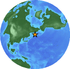
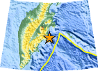
Magnitude 7.8 Near East Coast of Kamchatka
1997 December 05 11:26:54 UTC
Preliminary Earthquake Report
U.S. Geological Survey, National Earthquake Information Center
World Data Center for Seismology, Denver
|
Magnitude | 7.8 | |
| Date-Time | 1997 12 05 11:26:54 UTC | ||
| Location | 54.84N 162.03E | ||
| Depth | 33 kilometers | ||
| Region | Near East Coast of Kamchatka | ||
| Reference |
255 km (160 miles) W of Nikol'skoye, Komandorskiye Ostrova, Rus. 300 km (185 miles) NE of Petropavlovsk-Kamchatskiy, Russia 2730 km (1700 miles) NNE of TOKYO, Japan 6750 km (4200 miles) NNE of MOSCOW, Russia |
||
| Location Quality | Error estimate not available | ||
|
Location Quality Parameters |
Not available | ||
| Source | USGS NEIC (WDCS-D) | ||
| Comments | Felt (VII) in the epicentral area and (V) at Petropavlovsk-Kamchatskiy and Ust-Kamchatsk. Felt (II) at Severo-Kurilsk, Paramushir. Also felt aboard the cargo ship Stepan Krasheninnikov in the epicentral area. Tsunami generated with recorded wave heights (peak-to-trough) at the following selected tide stations: 15 cm on Adak and Unalaska, Alaska; 60 cm at Kahului, 52 cm at Haleiwa, 47 cm at Hilo, 30 cm at Hanalei, 12 cm on Midway, 10 cm at Snug Harbor and 5 cm at Honolulu, Hawaii. Complex earthquake with at least one event occurring about 14 seconds after the onset. |
|
|
NB:
The region name is an automatically generated name
from the Flinn-Engdahl (F-E) seismic and geographical regionalization scheme.
The boundaries of
these regions are defined at one-degree intervals and therefore differ from
irregular political boundaries.
More->
