
|
|
|
Investigators: Stacey Urner, Mary Ann Madej USGS-BRD Redwood Field Station Arcata, CA USA 707-464-6101 Ext. 5490 Fax: 707-822-8904 mary_ann_madej@usgs.gov
Partners:
|
 |
||
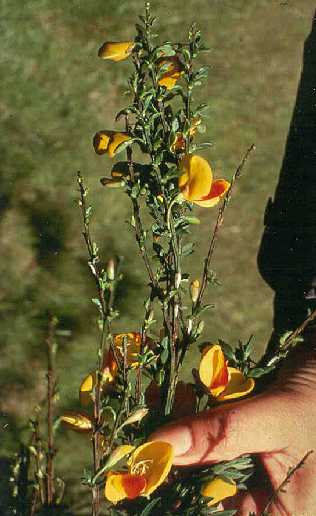
| Redwood National and State Parks have identified at least 190 exotic plants species, several of which are found in riparian areas. For example, Scotch Broom colonizes bare ground areas and open plant communities, and has been found along recently disturbed stream channels. |
Since 1974, monitoring of landslides and an extensive network of channel cross sections and longitudinal profiles have documented changes in streamside conditions that affect riparian vegetation. Floods are the dominant disturbance mechanism in riparian corridors in north coastal California but the effects of floods have been greatly modified by recent timber harvest, road construction and grazing activities. For example, the 1964 flood caused about 800 streamside landslides along the 100-km channel of Redwood Creek, and 80% of the slides were associated with roads or timber harvest units (Kelsey and others, 1995). The 1997 flood, with a 12-year return interval, resulted in 142 streamside landslides. Floods also resulted in increased areas of freshly disturbed sand and gravel. In the 1964 flood, nine meters of sand and gravel were deposited in headwater reaches (burying many of the riparian stands) and one to two meters of deposition was common in downstream reaches. Little work has been done to study the regrowth of redwood in disturbed riparian zones.
This project addressed three questions regarding the status of the riparian zone along Redwood Creek:
1) How have the overstory riparian conditions changed in Redwood Creek and major tributaries since the advent of timber harvest and following large floods (post-1948)?
2) What are the current distributions of conifers (Douglas fir and redwood) and exotics in the understory riparian stands in the Redwood Creek basin?
3) What are the implications of the changes in riparian composition for the long-term potential for shading and large woody debris recruitment to this coho-bearing river?
Study Area:
Redwood Creek, a sixth-order river in north coastal California, drains 720 km2 and is 100 km long. There are an additional 100 km of fifth-order tributary channels, many of which support anadromous fish stocks. Redwood National and State Parks occupy the downstream third of the watershed; the upstream two-thirds is privately owned. Timber harvest is the dominant land use, with scattered areas of grazing. By 1978, 81 percent of the original redwood and Douglas fir forests had been logged (Best, 1995). Buffer strips were not used in early timber harvest, and most commonly all trees were removed up to the water's edge. Stream reaches with closed canopies were common in the 1940's but rare by 1978.
Procedures
Changes in overstory riparian composition was documented through an analysis of sequential aerial photographs covering the Redwood Creek watershed at a scale of 1:12000 or 1:6000. Aerial photographs are available for several dates that bracket periods of intensive timber harvest and large floods: 1948, 1958, 1966, 1978, 1992 and 1997.
The analysis procedure to assess riparian function developed by the State of Washington's Department of Natural Resources (1995) was followed, with slight modifications for the Redwood Creek basin. The stream channel was categorized by segments based on land use and channel characteristics. For each photo year, both the right and left channel banks were mapped. Three characteristics of the riparian condition (timber harvest history, dominant riparian vegetation, and riparian stand density) were recorded for each segment on a mylar overlay map. The presence of young (understory) conifers and exotic plants in the riparian zone will be field inventoried in the summer of 1998.
Results
Table 1 lists changes in several riparian stand characteristics, based on the air photo analysis. The earliest air photos that were available are dated 1948, and by this time 7 % of the original coniferous forest upstream of parklands had been cut (Best, 1995). Most logging occurred after 1940, so we assume that most of the channel length was in "uncut, conifer-dominated, dense cover" status before 1940. Since 1948, there has been a dramatic decrease in length of uncut conifer riparian zones along Redwood Creek. In recent years some cover is returning to the channel's edge, but it is dominated by hardwoods, mostly alder, instead of redwood and Douglas fir. For example, in 1997 more than one half of Redwood Creek's riparian zone was dominated by hardwoods. The percentage of streambank that was classified as having sparse riparian cover was highest after the 1955 and 1964 floods. Sparseness of riparian vegetation also depends on the frequency and distribution of landslides, rural development and streamside agriculture.
Table 1: Changes in Riparian Characteristics Along Redwood Creek, California
Percentage of Channel Length As: *
| Air Photo Year | Uncut | Hardwood Dominated | Sparse Cover |
| 1948 | 86 | 27 | 3 |
| 1958 | 49 | 21 | 14 |
| 1966 | 28 | 22 | 18 |
| 1978 | 16 | 40 | 9 |
| 1992 | 15 | 54 | 4 |
| 1997 | 15 | 58 | 1 |
The lack of old-growth Douglas fir and redwood along much of the length of Redwood Creek has resulted in less shade along the channel, and on-going stream temperature studies in Redwood Creek show a concomitant increase in water temperature after disturbance, with a slight cooling trend as riparian vegetation becomes reestablished (USGS and NPS, unpublished data). The potential for recruitment of large woody debris to the stream channel is presently much less than in 1948 because of the removal of the large streamside conifers.
The results of this study are expected to provide quantitative information to park management regarding the decline of conifer-dominated zones in the Redwood Creek basin. Once the inventory is completed, the need for active management of the riparian zone will be evaluated and the information will also be provided to private landowners upstream of the park boundaries. Redwood National and State Parks have a Cooperative Agreement with the more than 20 major landowners upstream of the park to address resource concerns. Thus, the opportunity exists to promote stewardship on all lands in the watershed, and to encourage the restoration of conifer-dominated riparian zones.
Literature Cited
Best, D. 1995. History of timber harvest in the Redwood Creek basin, Northwestern California. Chapter C in Geomorphic processes and aquatic habitat in the Redwood Creek Basin, northwestern California. U.S. Geological Survey Professional Paper 1454. Nolan, K.M., H. M. Kelsey, and D. C. Marron, eds.
Kelsey, H.M., M. Coghlan, J. Pitlick, and D. Best. 1995. Geomorphic analysis of streamside landslides in the Redwood Creek Basin, Northwestern California. Chapter J in Geomorphic processes and aquatic habitat in the Redwood Creek Basin, northwestern California. U.S. Geological Survey Professional Paper 1454. Nolan, K.M., H. M. Kelsey, and D. C. Marron, eds.
Madej, M. A. and V. Ozaki. 1996. Channel response to sediment wave propagation and movement, Redwood Creek, California, USA. Earth Surface Processes and Landforms, Vol. 21: 911-927.
Washington Forest Practices Board. 1995. Standard Methodology for Conducting Watershed Analysis, under Chapter 222-22 WAC; Version 3. Watershed Analysis Appendix D - Riparian Function Assessment.
Keywords: Riparian, exotics, channel disturbance, floods, timber harvest
-- WERC Home -- Who We Are -- Where We Are -- What We Do -- What's New -- Outreach -- Contact Us -- Search --
USGS Privacy Policy, Disclaimer , Accessibility