


 Vaisala Ceilometer (VCEIL)
Instrument Categories: Cloud Properties
General Overview
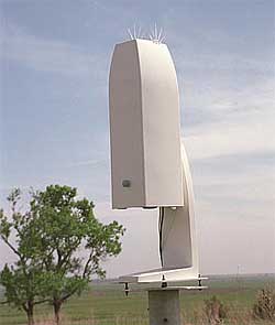
The Vaisala ceilometer (VCEIL) is a self-contained, ground-based, active, remote-sensing device designed to measure cloud-base height at up to three levels and potential backscatter signals by aerosols. Model CT25K has a maximum vertical range of 25,000 ft.
The ceilometer transmits near-infrared pulses of light, and the receiver telescope detects the light scattered back by clouds and precipitation.
Primary Measurements Taken
The following measurements are those considered scientifically relevant. Refer to the netCDF File Header Descriptions (Data Object Design Files) for the list of all available measurements, including those recorded for diagnostic or quality assurance purposes.
Available Datastreams
- vceil25k - Vaisala Ceilometer (VCEIL): cloud base heights, 25,000 feet max range
Sites / Facilities
Note: Click the "![]() " to expand/collapse the list.
" to expand/collapse the list.
- North Slope Alaska (NSA)
- Central Facility, Atqasuk AK (C2)
- Central Facility, Barrow AK (C1)
- Southern Great Plains (SGP)
- Central Facility, Lamont, OK (C1)
- Hillsboro, KS (Boundary) (B1)
- Morris, OK (Boundary) (B5)
- Purcell, OK (B6)
- Vici, OK (Boundary) (B4)
- SHEBA (Surface HEat Budget of the Arctic) (SHB)
- Ice Station SHEBA (C1)
- Tropical Western Pacific (TWP)
- Central Facility, Darwin, North Australia (C3)
- Central Facility, Manus I., PNG (C1)
- Central Facility, Nauru Island (C2)
- ARM Mobile Facility (FKB)
- Black Forest, Germany (M1)
- ARM Mobile Facility (NIM)
- Niamey, Niger (M1)
- ARM Mobile Facility (PYE)
- Point Reyes, CA (M1)
Mentor(s)
Victor Morris
(509) 372-6144
victor.morris@pnl.gov