|
Puerto Rico and the U.S. Island Areas were enumerated as part of the Census 2000 operation, with a Census Day of April 1, 2000. Data for Puerto Rico was processed with the rest of the United States. Data for Puerto Rico (in English) are shown in all standard Census 2000 data products, where Puerto Rico is shown as a state equivalent. Data for Puerto Rico (in Spanish) are available through the Censo 2000 Puerto Rico website.
Census 2000 operations in American Samoa, the Commonwealth of the Northern Mariana Islands, Guam, and the U.S. Virgin Islands (collectively referred to as the U.S. Island Areas) were conducted by the government of each Island Area in partnership with the Census Bureau. These partnerships were designed to ensure that Census 2000 data met the legal requirements set forth in Title 13, U.S. Code, as well as the specific needs of each Island Area. Each Island Area had its own questionnaire, and data were processed separately.
American Samoa
American Samoa is an unorganized, unincorporated territory of the United States. It consists of five major volcanic islands and two coral atolls (see Figure 1) that lie in the heart of Polynesia, 2,500 miles south-southwest of Honolulu and 1,800 miles north-northeast of New Zealand. It is the only U.S. jurisdiction that lies south of the equator. Tutuila Island, which contains the historic capital of Pago Pago, the seat of government at Fagatogo, and the office of the Governor at Utulei, encompasses 70 percent of American Samoa's 77.3 square miles and over 95 percent of its 46,773 inhabitants (see Figure 1).
In 1839, the visit of an American naval vessel marked the first official United States contact with this area. In 1872, the need for a coaling station brought about an agreement between the commander of the U.S. naval vessel Narragansett and the chief of Pago Pago; although the agreement was never ratified by the U.S. Senate, it prevented other nations from making claims on Pago Pago Harbor as international competition for bases in the South Pacific increased.
On December 2,1899, the United States, Great Britain, and Germany signed a convention wherein the United States retained Eastern Samoa but gave up claims to the islands that now constitute the Independent State of Samoa (formerly known as Western Samoa); the convention was ratified by Congress on February 16,1900. Three days later. President William McKinley, seeking a suitable harbor and fueling station for American vessels in the South Pacific, directed the U.S. Navy to establish United States authority over the area. This was followed by negotiation of a series of deeds of cession with the chiefs of Tutuila (concluded on April 17,1900) and the chief of the Manu'a group (in July 1904). Swains Island, a coral atoll, was settled by an American in 1856, and his citizenship tied it to the United States; the island officially became part of American Samoa in 1925.
The U.S. Navy governed American Samoa until June 29, 1951, when an Executive Order transferred the administration of the territory to the Department of the Interior. In I960, American Samoa adopted a constitution. Since 1981, American Samoa has been represented in the U.S. House of Representatives by a nonvoting delegate. (The 103rd Congress gave the delegates from those Outlying Areas represented in the House of Representatives the right to vote in the Committee of the Whole, but not on matters before the entire House.) The Samoan language is spoken commonly in the territory.
Figure 1. American Samoa 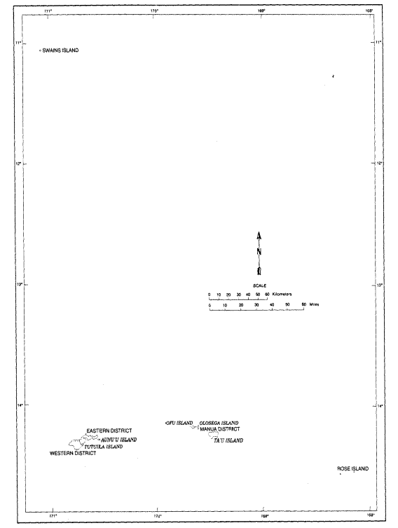
Guam
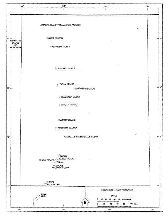
Guam is the largest and southernmost island of a chain of volcanic islands in part of Micronesia known as the Marianas Archipelago (see Figure 2). It is an organized, unincorporated territory of the United States and is located in the western Pacific Ocean, 6,000 miles southwest of San Francisco, 3,700 miles west of Honolulu, 1,500 miles south of Tokyo, and 1,500 miles east of Manila. Inhabited for more than 3,500 years, the discovery of Guahan or Guan (as the Spanish documented the name apparently used by the indigenous population) in 1521 by Ferdinand Magellan was the basis for Guam coming under Spanish rule. Spain claimed Guam and the Marianas in 1565, established a supply station on Guam the next year, and established the first permanent Spanish settlement in 1668. As a result of the Spanish-American war, Spain ceded Guam to the United States by the Treaty of Paris on December 10,1898.
Diseases and conflicts resulted in the near annihilation of the original Gua-manians, known as Chamorros. Intermarriage of Spaniards and Filipinos with Chamorros during the 18th and 19th centuries gave rise to the modern Guamanian race and culture, and Chamorro is still commonly spoken in Guam. Over 90 years of American influence also has had its effect on modern-day Guam, as did the Japanese occupation during World War II. Guam became a major military site for the United States after its liberation in August 1944. In fact, since the end of World War II, approximately one-third of Guam's land area has been owned by the Federal Government, most of it in military reservations; in 1980, almost 20,000 people, or over 18 percent of Guam's population, lived on military bases--primarily Andersen Air Force Base, Finegayan Naval Communication Station, and Apra Harbor Naval Reservation--and on U.S. Navy ships for which Guam was the home port.
The U.S. Navy was responsible for the administration of Guam from 1898 until June 30,1950, when the U.S. Government transferred that obligation to the Department of the Interior. The Organic Act of Guam (1950) enabled Guamanians to elect their own legislature, an at-large 21-member senate. The President of the United States appointed the governor of Guam until 1970; since that year, as a result of legislation signed by President Lyndon Johnson on September 11,1968, Guamanians have elected a governor and lieutenant governor. In addition, since 1973, Guam has been represented in the U.S. Congress by an elected nonvoting delegate. In recent years, Guam has been trying to obtain commonwealth status, which would give it more control of some of its affairs than the current home rule it now exercises.
Figure 2: Guam and the Northern Mariana Islands
The Commonwealth of the Northern Mariana Islands
The Commonwealth of the Northern Mariana Islands, which is part of Micronesia, comprises the former Mariana Islands District of the Trust Territory of the Pacific Islands. It consists of three main islands--Saipan, Tinian, and Rota--and several small islands and atolls (see Figure 2). It is located just north of Guam; Saipan lies about 125 miles northeast of Guam, but southernmost Rota is less than 50 miles from Guam. The islands that constitute the Northern Marianas encompass some 430 miles from Rota in the south to Uracus Island in the north, but it is only 75 miles from Rota to Saipan; the lightly populated Northern Islands (an exodus, primarily due to volcanic activity, reduced the number to only 36 in 1990 and even fewer by 1992) stretch over some 300 miles of the Pacific. The Commonwealth's capital is Saipan, but no locality on that island is recognized specifically as the capital; several (but not all) government offices are located in the CDP of Capital Hill, but the legislature meets in Susupe. Almost 90 percent of the population lives on Saipan. As in Guam, Chamorro is the most common native language spoken in the Northern Mariana Islands.
The early history of these islands paralleled that of Guam. Spanish and other explorers first visited the islands in the l6th century. Spain began colonizing the islands in 1668. Originally called Islas de Ladrones (Islands of Thieves), the Spanish renamed them in 1688 in honor of Queen Mariana of Spain. Spain sold the Marianas, as well as the Carolines and Marshalls, to Germany in 1899 to raise money after the Spanish-American War. In 1914, during World War I, Japan claimed jurisdiction over all these islands after entering the war on the side of the Allied Powers; it retained them officially under a 1919 mandate of the League of Nations. The United States gained control of the islands through military victories in 1944, and established a military government following World War II. On July 18, 1947, under a joint resolution of the U.S. Congress, President Harry Truman approved a trusteeship agreement between the United States and the Security Council of the United Nations, with the administrative authority resting with the Department of the Interior since June 29,1951; however, because of their strategic significance, the Commonwealth of the Northern Mariana Islands remained under military control until 1961.
During the 30 years that followed, the U.S. Government provided the basis for the entities within the Trust Territory of the Pacific Islands (TTPI) to make a steady movement toward self-government. After extensive negotiations, the United States and the Northern Mariana Islands concluded a covenant on February 15, 1975, that would result in that entity becoming a commonwealth of the United States. In 1977, the U.S. Government announced its intention to terminate the trusteeship as soon as possible. Over several years, the governmental framework of the TTPI restructured itself into four separate entities, one of which corresponded to the Northern Mariana Islands; each adopted a new constitution, held elections, established its own government, and began to function autonomously, although within the framework of the trusteeship. The establishment of a separate government for the Northern Mariana Islands took place in January 1978 with the reorganization of the Mariana Islands District of the TTPI as the Commonwealth of the Northern Mariana Islands (CNMI). Final commonwealth status did not come until November 3,1986, when President Ronald Reagan issued a proclamation that dissolved the trusteeship agreement for all of the TTPI except Palau.
However, the Census Bureau treated the CNMI separately from the TTPI in the 1980 census tabulations because the legal structure for its commonwealth relationship with the United States was already in place. Citizens of the CNMI elect a governor and lieutenant governor, a 15-member House of Representatives, and a 9-member Senate. The CNMI does not have representation in the U.S. Congress.
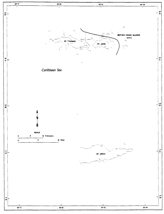
The Virgin Islands of the United States is an organized, unincorporated territory of the United States located immediately east of Puerto Rico (see Figure 3). Although more than 50 separate islands and cays constitute this westernmost of the Lesser Antilles, only three have a size and population of any significance: St. Thomas, St. Croix, and St. John. Almost all the other islets are both uninhabited and uninhabitable. Most of the population is shared equally by St. Croix and St. Thomas, although St. Croix is considerably larger in area. The capital is located in Charlotte Amalie on St. Thomas.
The European discovery of the islands occurred when Columbus first sighted Santa Cruz, now known as St. Croix. Exploring further, he found the islands of St. Thomas, St. John, Tortola (part of what is now the British Virgin Islands), and others, and named them collectively Las Virgenes (a name that means the Virgins, supposedly for the 11,000 virgins of St. Ursula). In the 17th century, the islands became part of the colonial struggle waged by France, England, Spain, Holland, and, later, Denmark, with the islands' sugar production the primary reason for controlling them. Denmark chartered the Danish West Indian Company and began colonizing St. Thomas (1671) and then St. John (1684). Denmark purchased St. Croix from France in 1733 and, except for a brief period of English occupation of St. Croix during the Napoleonic Wars, the islands remained under Danish control until 1917. As early as 1865, for strategic military reasons, the United States made overtures to acquire the islands. During World War I, fear that Germany might occupy the islands provided the final impetus for the United States to purchase the islands from Denmark, for $25 million on March 31, 1917. The islands were under the jurisdiction of the Department of the Navy until February 27,1931, when an Executive order placed them under the supervision of the Department of the Interior. In 1927, Virgin Islanders were granted U.S. citizenship. Since 1970, they have elected their governor, lieutenant governor, and a 15-member legislature. Since 1973, the Virgin Islands have been represented in the U.S. House of Representatives by a nonvoting delegate. English is the language commonly spoken. The Danish government conducted 11 censuses from 1835 through 1911. In 1917, the Census Bureau took a special census of the Virgin Islands, but the islands were not included in the decennial and agriculture censuses until 1930, or in the economic censuses until 1958.
The only functioning governmental unit in the Virgin Islands is the territorial government. On October 11,1993, Virgin Islanders had the opportunity to consider changing the territory's relationship with the United States. Eighty percent voted to retain territorial status; however, the referendum was legally meaningless because more than 50 percent of the eligible voters had to participate, but only 27.4 percent did so.
The Census Bureau treats the three main islands as the statistical equivalents of counties, but they do not have their own governments. Nearby islands are included with the closest large island; for example, Water Island, offshore from Charlotte Amalie, is included with St. Thomas. For administrative purposes, some government offices separately serve St. Croix and, jointly, St. Thomas/St. John, but these are part of the territorial government.
Figure 3: U.S. Virgin Islands