Census 2000 Summary File 4 Disc Product Support
Getting Started
Overview
Census 2000 Summary File 4 (SF4) contains each data iteration for a state in a separate database. The Census 2000 Data Engine software is a customized version of SRC's Allocate product. Some of its basic functionality is illustrated below. Refer to the product's Help function for a complete overview of the software's functionality.
Immediate installation and use of the software requires being logged on as either an administrator or a power user on a PC with Windows 2000 or later versions such as XP. The following procedure can be used to install and run the software while logged in as a regular user in the versions of Windows mentioned above.
Census 2000 Data Engine and Windows 2000 User Rights
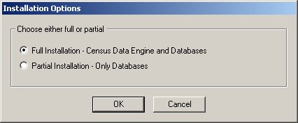
Installation
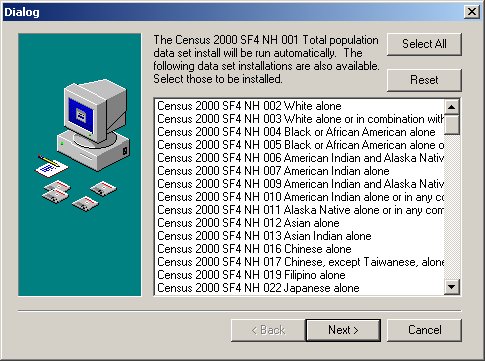
If you have previously installed the software from another disc, select Partial installation.
Select data interation(s) to install.
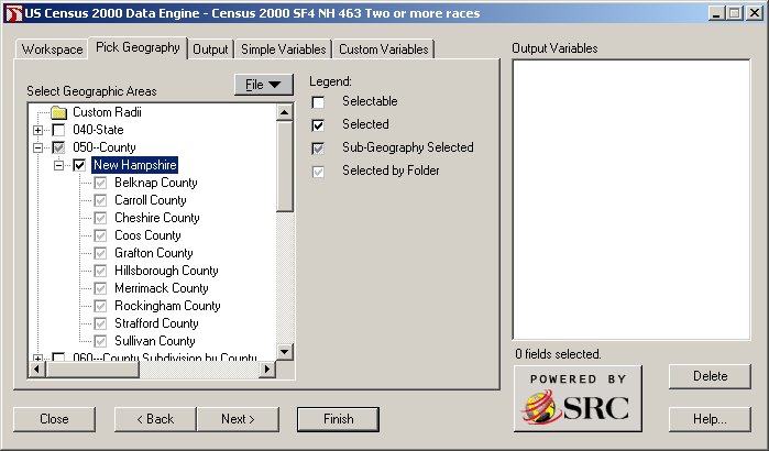
Pick Geography
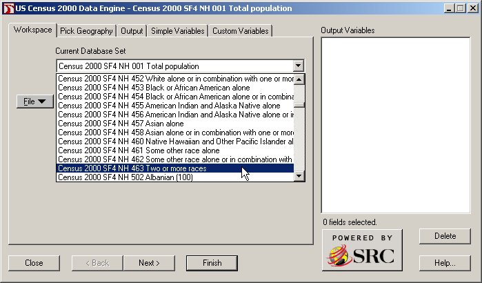
First, select data iteration to query from the Workspace tab.
Example: Select all county records in New Hampshire (for selected data iteration).
Procedure: Click on + (the plus sign) to the left of County first and then select New Hampshire. If you only
want to select a few specific counties in New Hampshire, next click on + to the left of New Hampshire and then
select individual counties of interest. The "tree" on each of the software tabs works in the same way.
Output Report
Example: Produce Detailed Table PCT001. Total Population:2000 report.
Procedure: Select the Report output mode, and select this report from the Quick
Tables folder, then click Finish. (Many other report templates for Detailed Tables and Quick Tables are available
through Browse).
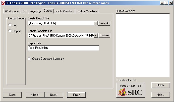
"Total population" was typed in the Report Title text box in this example.
A separate file is created for each individual area selected from the Pick Geography tab. If more than one area is selected, a home page with a set of hyperlinks is also created.
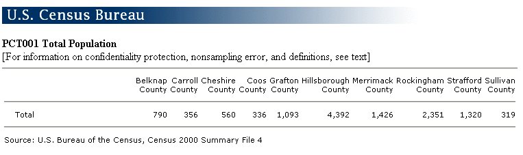
Display Report
Example: Display or print reports.
Procedure: Your internet browser is used to display and/or print reports.
Simple Variables
Example: Specify Simple Variables to include in an Output File or in a custom report using the
Report (Blank) template.
Procedure: Select whole tables or individual data items to be included in an
Output File. The Simple Variables selected can also be included in a custom report using the Report
(Blank) template.
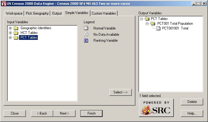
Geographic identifiers can also be selected from this screen by clicking on the + sign to the left of Geographic Identifiers. If more than one area type from the Pick Geography tab was selected, it will be necessary to select the geographic identifier variable Sumlev.
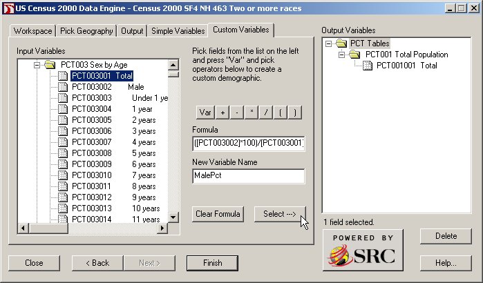
Custom Variables
Example: Specify Custom Variables to include in an Output File or in a custom report using the
Report (Blank) template.
Procedure: Create new variables derived from Simple Variables.
Include Custom Variables in an Output File or in a custom report using the Report (Blank) template.
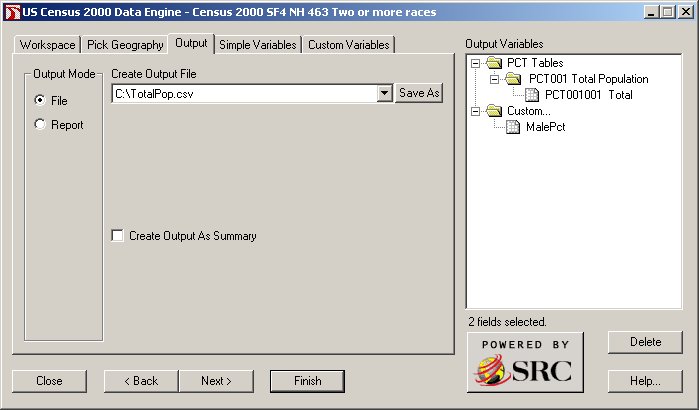
Output File
Example: Specify the name and type of an Output File.
Procedure: Select File output mode, then click on the Save As button and specify
the file name and type, and click Finish. This example uses the CSV type (comma-separated values).
The output file will include records (or rows) based on selections made from the Pick Geography tab and fields (or columns) based on selections made from the Simple Variables tab (including geographic identifiers and/or data items) and Custom Variables tab.
If the "Create Output As Summary" box is checked, your output file will contain only one record which includes a total for all of the individual areas selected from the Pick Geography tab. Leave this box unchecked if you want the detail data.
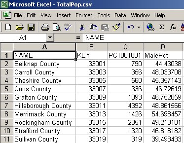
Display File
Example: Display the Output File.
Procedure: The Census 2000 Data Engine software does not contain functionality to display an Output
File. This is done through companion software. In this example, Microsoft Excel is installed on the computer and the
operating system is configured to automatically launch Excel for CSV files.
Using the file documentation as a reference
File documentation [5.32 MB]

The Census 2000 Summary File 4 file documentation is contained in a file named sf4.pdf on the disc. The relationship between the different tabs of the software interface and the file documentation appears below.
Chapter 4 (Summary Level Sequence Chart) can be used to find complete descriptions of area types (for which summary data is available) on the Pick Geography tab. Codes for each element making up the complete summary level description will appear as part of a field labeled KEY in output files created by the software. These codes, additionally, can also be included as separate fields by selecting the Simple Variables tab and then clicking on the + sign to the left of Geographic Identifiers folder. Chapter 7 (Data Dictionary Identification section) contains descriptions of all geographic identifiers. Appendix A contains definitions of all geographic terms.
Chapter 3 (Subject Locator) can be used to more quickly find demographic data tables from the Simple Variables tab. The Table Matrix section of Chapter 7 (Data Dictionary Table Matrix section) contains complete table information.
Updates
07/26/2004
The latitude and longitude fields INTPTLAT and INTPTLON contain coordinates to six digits of decimal precision. Only five of these decimals are exported to the dBase 5 file type. This problem seems to be limited solely to the dBase 5 file type. The INTPTLAT and INTPTLON fields are in the Geographic Identifiers folder from the Simple Variables tab.
Technical Support