1999 Country Based Metropolitan Areas Page Size Maps

There are three 1999 U. S. Based Metropolitan Area map types as follows:
|
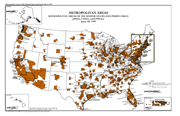
11x17 Metropolitan Areas Map
with separate 8.5x11 Inset |
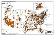
11x17 Metropolitan Areas Map
|
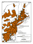
Two Page 8.5x11 Metropolitan Areas Map
|
|
|
 |
 .. ..
 |
The 1999 U. S. Based Metropolitan Area Page Sized Maps show the extent of the 1999 Metropolitan Areas for the entire United States and Puerto Rico.
The maps are available on-line in Portable Document Format (PDF). In order to view these files, you will need the Adobe® Acrobat® Reader Version 4.0 or above, which is available free from the Adobe web site. Printed copies of the maps are also available.
11x17 Metropolitan Areas Map with seperate 8.5x11 Inset [PDF] 427 KB
11x17 Metropolitan Areas Map [PDF] 426 KB
8.5x11 Two Page Metropolitan Areas Map [PDF] 424 KB
Source: U.S. Census Bureau
Last Revised: January 26, 2006 at 01:25:59 PM