
NOAA, Partners Remain Active in Spill Response
Natural Resource Damage Assessment Process Underway
November 14, 2007
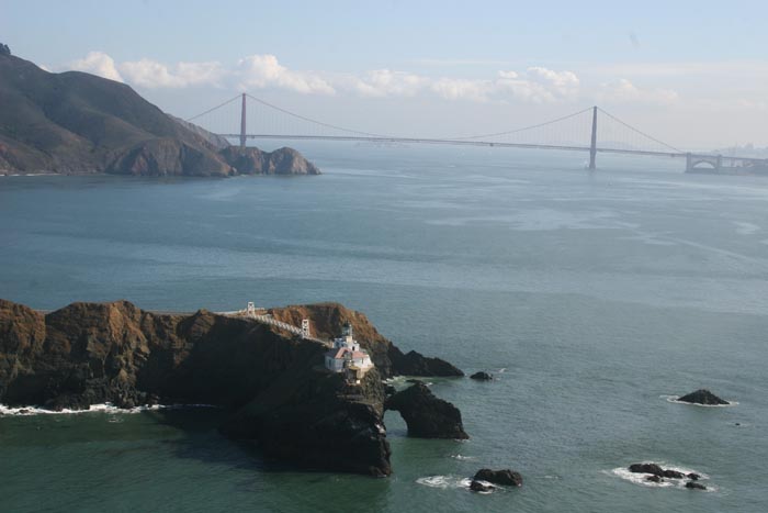
Pt. Bonita in foreground looking across sheens eastward to Golden Gate Bridge and San Francisco Bay (Nov. 9, 2007).
+ High Resolution (Credit: NOAA/NMS)
NOAA organizations remain active in San Francisco aiding in the response to last week's spill of an estimated 58,000 gallons of intermediate fuel oil on Nov. 7 when the container ship M/V Cosco Busan struck the Oakland Bay Bridge in San Francisco Bay.
NOAA's Office of Response and Restoration continues providing scientific support to the Unified Command, which is led by the U.S. Coast Guard, State of California's Fish and Game Office of Oil Spill Prevention and Response and a representative of the shipping company. NOAA and the Department of Interior are working within the response, and with other state and federal trustees to develop the natural resource damage assessment.
The overall response operations, according to the U.S. Coast Guard, include over 1,200 active participants from federal, state and local agencies. The U.S. Coast Guard reports that approximately 80 different vessels, including oil response vessels, skimmers, and support ships, have been active since the spill.

NOAA Scientific Support Coordinator Jordan Stout working in the command center.
+ High Resolution (Credit: NOAA)
NOAA's Integrated Ocean Observing System regional partner, the Central and Northern California Ocean Observing System through the state-funded Coastal Ocean Current Monitoring Program, has been assisting in the spill tracking as well as using High Frequency Radar systems both within San Francisco Bay and the Gulf of Farallones in an effort to provide real-time information to the response teams. The derived currents are being sent directly to responders as well as posted on the CeNCOOS Web pages. CeNCOOS continues to work with its partners, providing environmental information as it is requested by NOAA HAZMAT, NOAA National Marine Sanctuary Program, State of California Department of Fish and Game, and California Office of Spill Prevention and Response.
Clean-up progress includes beach areas of Alameda and Contra Costa counties. Over-flights and assessment have determined that there remains very little surface water oil product that is recoverable and a total of 14,974 gallons of the oil have been recovered through Nov. 14.
The coastline and resources of NOAA's Monteray Bay National Marine Sanctuary and Gulf of the Farallones National Marine Sanctuary were affected when oil moved outside the Golden Gate. This region is a destination feeding area for thousands of marine species, and the oil has not only contaminated the food supply, but also has affected the coastal intertidal habitats.
As of Nov.14, 804 live oiled birds have been collected, of which 244 were washed and 105 were euthanized. An additional 590 dead birds have been collected. Oiled birds were reported within the Monterey Bay National Marine Sanctuary, within Marin County at Muir Beach and Rodeo Beach, and within the Gulf of the Farallones National Marine Sanctuary as far north as Point Reyes.
As of Nov. 14, no oil has affected the Farallon Islands .The Farallones, where the largest concentration of breeding seabirds in the contiguous United States is found, provide a diverse intertidal habitat, thriving with mussels, algae, abalone and seastars, and provide resting areas and breeding grounds for pinnipeds, such as sea lions, harbor seals, endangered northern fur seals, and elephant seals.
NOAA’s national marine sanctuaries outside the Golden Gate are important feeding grounds for endangered humpback and blue whales. Both whale species and migratory seabirds such as Albatross, Cassin’s Auklets, and Shearwaters were observed within the Cordell Bank National Marine Sanctuary, north of the Farallon Islands, during a wildlife survey on Friday, Nov. 9.

Nov. 9 overflight Southeast Farallon Islands Closeup. No oil observed.
+ High Resolution (Credit: NOAA)
NOAA staff on scene continue to include representatives from NOAA's Office of Response and Restoration’s Emergency Response Division, NOAA National Marine Sanctuary Program, NOAA Fisheries Service Offices of Habitat Conservation, Protected Resources, the Restoration Center, and the NOAA Marine Debris Program,
which seeks to mitigate marine pollution effects.
NOAA National Weather Service Marine Forecasters continue to provide twice a day spot weather support, including wind forecasts that are being incorporated into the spill trajectory models. This information will be updated continuously throughout the coming days and integrated into both trajectory predictions and planning of response operations.
NOAA National Marine Sanctuary Program staff and Beach Watch volunteers are participating in wildlife surveys both north and south of the Golden Gate to assess the spills affects on the area's marine and bird life as well as rescue any oiled animals if necessary. These volunteers have received special training in emergency response and are certified to assist.
The public is still urged to avoid areas and wildlife that are affected, as untrained people can cause further damage to the environment and stress on the wildlife. The public also is reminded that allowing dogs to run on affected beaches will create even greater stress for injured wildlife. Concerned citizens should call 415-701-2311 to report any sightings of oiled wildlife. Please note this is a new number, the previous number is no longer in service.

Photo of tarballs and starfish on Muir Beach, Nov. 10, 2007.
+ High Resolution (Credit: NOAA)
Members of the public without proper training should not attempt to collect the oil, since it needs to be disposed of properly to prevent broader contamination and re-introduction to the environment. In addition, exposure to the oil can be hazardous to human health.
NOAA Fisheries' Marine Animal Health Program and our partners in the marine mammal stranding network are actively engaged in the oil spill incident response, in collaboration with the California Oiled Wildlife Care Network, in evaluating oiled marine mammals to determine whether intervention is needed for rescue and rehabilitation. Personnel from NOAA’s Restoration Center are on scene evaluating effects to eel grasses, oyster beds and potential impacts to threatened coho salmon and steelhead along the Marin headlands.
In addition to support for the oil spill response, several NOAA offices are participating in an Natural Resource Damage Assessment. The current phase of the NRDA is a natural resource injury assessment, which will identify and quantify affects to natural resources and services, such as fish, birds, mammals, habitats, cultural resources, and public recreational uses of natural resources. If injuries are confirmed, NOAA will assess damages from the responsible party to conduct restoration that will compensate the public for lost resources and resource services. NOAA is working cooperatively with the responsible party and other state and federal trustees including U.S. Department of Interior agencies — U.S. Fish & Wildlife Service, National Park Service and the Bureau of Land Management — and the California Office of Spill Prevention and Response on the initiation of the NRDA.
NOAA offices involved in the NRDA include the Office of Response and Restoration (Emergency Response Division and Assessment and Restoration Division), NOAA Fisheries (Restoration Center), the Monterey Bay, Gulf of the Farallones and Cordell Bank National Marine Sanctuaries and the Office of the General Counsel for Natural Resources. Initial work is focused on obtaining early evidence of oiling and evidence of the effects of oiling on trust resources. NOAA personnel are in the field documenting the effects of the spill and gathering samples for subsequent analysis.
In August 2006, NOAA led a San Francisco-based, multi-agency federal, state, regional, and local oil spill drill called "Safe Seas." The drill was designed to help the participants improve their ability to use a broad range of scientific capabilities, technologies and skills to reduce harm to the marine and coastal resources when an incident occurs. Among the capabilities tested in that drill was the delivery of data, observations, forecasts, and expertise from public and private resources. Many of those same organizations are involved in this response.
NOAA's Office of Response and Restoration protects the public’s natural resources, responds to hazardous material releases, and restores injured and contaminated marine and coastal environments. The NOAA Emergency Response Division consists of an interdisciplinary scientific team that responds to oil and chemical spills in U.S. waters and helps the On-Scene Coordinator make timely operational decisions. NOAA's Scientific Support Coordinators, located around the country, lead the team at spills, drawing on the team's spill trajectory estimates, chemical hazards analyses, and assessments of the sensitivity of biological and human-use resources.
The National Oceanic and Atmospheric Administration, an agency of the U.S. Commerce Department, is celebrating 200 years of science and service to the nation. From the establishment of the Survey of the Coast in 1807 by Thomas Jefferson to the formation of the Weather Bureau and the Commission of Fish and Fisheries in the 1870s, much of America's scientific heritage is rooted in NOAA.
NOAA is dedicated to enhancing economic security and national safety through the prediction and research of weather and climate-related events and information service delivery for transportation, and by providing environmental stewardship of our nation's coastal and marine resources. Through the emerging Global Earth Observation System of Systems (GEOSS), NOAA is working with its federal partners, more than 70 countries and the European Commission to develop a global monitoring network that is as integrated as the planet it observes, predicts and protects.