
 Feeds & Data
Magnitude 7.2 - PAGAN REGION, NORTHERN MARIANA ISLANDS
2007 October 31 03:30:20 UTC
Earthquake Details
| Magnitude | 7.2 |
|---|---|
| Date-Time |
|
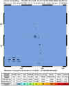
| Location | 18.854°N, 145.315°E |
| Depth | 248.3 km (154.3 miles) |
| Region | PAGAN REGION, NORTHERN MARIANA ISLANDS |
| Distances | 40 km (25 miles) WNW of Agrihan, Northern Mariana Islands 100 km (65 miles) NNW of Pagan, Northern Mariana Islands 410 km (255 miles) N of SAIPAN, Northern Mariana Islands 605 km (375 miles) N of HAGATNA, Guam |
| Location Uncertainty | horizontal +/- 4.8 km (3.0 miles); depth +/- 12.5 km (7.8 miles) |
| Parameters | NST=260, Nph=260, Dmin=584 km, Rmss=0.92 sec, Gp= 25°, M-type=moment magnitude (Mw), Version=7 |
| Source |
|
| Event ID | us2007jdal |
- This event has been reviewed by a seismologist.
- Did you feel it? Report shaking and damage at your location. You can also view a map displaying accumulated data from your report and others.
Earthquake Summary


The following is a release by the United States Geological Survey, National Earthquake Information Center: An earthquake occurred about 40 km (25 miles) WNW of Agrihan or 405 km (250 miles) N of SAIPAN at 9:30 PM MDT, Oct 30, 2007 (Oct 31 at 1:30 PM local time in Mariana Islands). The magnitude and location may be revised when additional data and further analysis results are available.
Felt Reports
WP 6.9 (GS).
Tectonic Summary
The Mariana Islands earthquake of October 31, 2007, occurred in the inclined seismic zone that marks the position of the subducted Pacific plate beneath the overriding Philippine Sea and Mariana plates. The earthquake represents the release of stress resulting from the distortion of the Pacific plate. Earthquakes, such as this one, that have focal depths between 70 and 300 km are commonly termed "intermediate-depth" earthquakes. "Deep-focus" earthquakes, with focal depths greater than 300 km, also occur in the subducted Pacific plate beneath the Mariana island arc. Earthquakes have been reliably located to depths of about 630 km beneath the Mariana arc.
Although the broad-scale tectonics of the epicentral region are dominated by the subduction of the Pacific plate beneath the Philippine Sea plate, the two plates do not have a mutual boundary at the latitude of the earthquake. Instead, they are separated by a spreading ridge (the Mariana Trough) and the small Mariana plate. The Pacific plate thrusts under the Mariana plate at the Mariana Trench. In this region, the Pacific plate moves to the west with respect to the interior of the Philippine Sea plate with a velocity of about 40 mm/year, and it moves to the west with respect to the Mariana plate with a velocity of about 60 mm/year.
 Tsunami Information
- NOAA West Coast & Alaska Tsunami Warning Center
- NOAA Pacific Tsunami Warning Center
- Tsunami Information Links
The earthquake locations and magnitudes cited in these NOAA tsunami bulletins are very preliminary and may be superceded by USGS locations and magnitudes computed using more extensive data sets.
Earthquake Maps


Scientific & Technical Information

- Preliminary Earthquake Report
- U.S. Geological Survey, National Earthquake Information Center:
World Data Center for Seismology, Denver
