Magnitude 7.6 - PAKISTAN - usdyae
2005 October 8 03:50:40 UTC
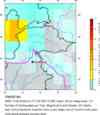
A major earthquake occurred at 03:50:40 (UTC) on Saturday, October 8, 2005.
The magnitude 7.6 event has been located in PAKISTAN.
(This event has been reviewed by a seismologist.)
Earthquake Summary
Felt Reports
At least 86,000 people killed, more than 69,000 injured and extensive damage in northern Pakistan.The heaviest damage occurred in the Muzaffarabad area, Kashmir where entire villages were destroyedand at Uri where 80 percent of the town was destroyed. At least 32,335 buildings collapsed inAnantnag, Baramula, Jammu and Srinagar, Kashmir. Buildings collapsed in Abbottabad, Gujranwala,Gujrat, Islamabad, Lahore and Rawalpindi, Pakistan. Maximum intensity VIII. Felt (VII) at Topi; (VI)at Islamabad, Peshawar and Rawalpindi; (V) at Faisalabad and Lahore. Felt at Chakwal, Jhang,Sargodha and as far as Quetta. At least 1,350 people killed and 6,266 injured in India. Felt (V) atChandigarh and New Delhi; (IV) at Delhi and Gurgaon, India. Felt in Gujarat, Haryana, HimachalPradesh, Madhya Pradesh, Punjab, Rajasthan, Uttaranchal and Uttar Pradesh, India. At least oneperson killed and some buildings collapsed in Afghanistan. Felt (IV) at Kabul and (III) at Bagrami,Afghanistan. An estimated 4 million people in the area left homeless. Landslides and rockfallsdamaged or destroyed several mountain roads and highways cutting off access to the region forseveral days. Landslides occurred farther north near the towns of Gilgit and Skardu, Kashmir.Liquefaction and sandblows occurred in the western part of Vale of Kashmir and near Jammu.Landslides and rockfalls also occurred in parts of Himachal Pradesh, India. Seiches were observed inHaryana, Uttar Pradesh and West Bengal, India and many places in Bangladesh.
Earthquake Information for ASIA
Earthquake Information for PAKISTAN
Earthquake Details
| Magnitude |
7.6 |
| Date-Time |
Saturday, October 8, 2005 at 03:50:40 (UTC)
= Coordinated Universal Time
Saturday, October 8, 2005 at 8:50:40 AM
= local time at epicenter
Time of Earthquake in other Time Zones
|
| Location |
34.493°N, 73.629°E |
| Depth |
26 km (16.2 miles) set by location program |
| Region |
PAKISTAN |
| Distances |
105 km (65 miles) NNE of ISLAMABAD, Pakistan
115 km (70 miles) ESE of Mingaora, Pakistan
125 km (75 miles) WNW of Srinagar, Kashmir
165 km (105 miles) SSW of Gilgit, Kashmir
|
| Location Uncertainty |
horizontal +/- 3.6 km (2.2 miles); depth fixed by location program |
| Parameters |
Nst=280, Nph=280, Dmin=907.3 km, Rmss=0.79 sec, Gp= 22°,
M-type=teleseismic moment magnitude (Mw), Version=U
|
| Source |
USGS NEIC (WDCS-D)
|
| Event ID |
usdyae |
Earthquake Maps

Earthquake Location
Scientific & Technical Info
Additional Information, News Reports
- Preliminary Earthquake Report
- U.S. Geological Survey, National Earthquake Information Center
World Data Center for Seismology, Denver

 Feeds & Data