
Markikina Fault
Multiple large earthquakes in the past 1500 years on a fault in metropolitan Manila, The Philippines
(published in the Bulletin of Seismological Society of America, 2000, vol. 90, p. 73-85)
Alan R. NelsonStephen F. Personius
Geologic Hazards Team, Central Region U.S. Geological Survey, MS 966
PO Box 25046,
Denver, Colorado 80225, USA Rolly E. Rimando
Raymundo S. Punongbayan
Norman Tuñgol
Hannah Mirabueno
Ariel Rasdas
Philippine Institute of Volcanology and Seismology,
University of the Philippines, Diliman, Quezon City,
The Philippines
Figure 1
ABSTRACT
The first 14C-based paleoseismic study of an active fault in The Philippines shows that a right-lateral fault on the northeast edge of metropolitan Manila poses a greater seismic hazard than previously thought. Stratigraphic, soil, and 14C data from exposures across the northern part of the west Marikina Valley fault indicate a recurrence interval of 200-400 years for magnitude 6-7 earthquakes on the fault. Stratigraphic relations among faults and silty hillslope colluvium, gravelly stream-channel alluvium, and cobbly debris-flow deposits exposed in trenches-and three reddish, clay-rich B soil horizons developed on those deposits-record three surface-faulting events. AMS 14C ages on detrital charcoal constrain the entire stratigraphic sequence to the past 1300-1700 years, and clay-rich soils point to earthquake recurrence intervals of >200 years. Minimal soil development and modern 14C ages from colluvium overlying a faulted debris-flow deposit in a nearby stream exposure show that the most recent, fourth faulting event is historic, probably dating from the past 200 years.
INTRODUCTION
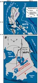
Recent assessment of the earthquake hazard posed by crustal faults in cities such as Los Angeles and Seattle, and the economic and human loss resulting from recent damaging earthquakes in Northridge, California, and Kobe, Japan highlight the need for evaluating potentially active crustal faults in urban areas. Manila--with a metropolitan population of about 10 million--is similarly subject to earthquakes on nearby crustal faults, as well as earthquakes on more distant plate-boundary faults (Fig. 1A). The city has been heavily damaged by earthquakes at least six times in the past 400 years, but the specific sources for the earthquakes are uncertain. The Marikina Valley fault system, on the northeastern edge of the Manila metropolitan area (Metro Manila, Figs. Fig. 1A and Fig. 2A), is a likely source one or more of these earthquakes. Determining the rate of recurrence of large earthquakes on these shallow crustal faults is critical for estimating the strength and probability of future earthquake ground motions in the metropolitan area.
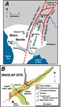
In 1995-96 we made the most successful attempt to determine earthquake recurrence on a hazardous fault in The Philippines-the westernmost fault in the Marikina Valley system, which lies only 10 km east of central Manila (Fig. 2A). Stratigraphic, soils, and 14C data obtained from trenches and stream bank exposures at the Maislap trench site show that a northern splay of the west Marikina Valley fault (Fig. 2A) has produced at least four large earthquakes in the past 1300-1700 years. Such a history suggests a rate of slip several times greater than might be expected from a fault with less than 30 km of physiographic expression located more than 60 km from active plate boundaries (Fig. 1A).
Figure 3
CONCLUSIONS: MAGNITUDE AND FREQUENCY OF LARGE EARTHQUAKES ON THE MARIKINA VALLEY FAULT SYSTEM
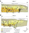
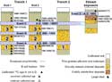
Based on our interpretation of the exposures at the Maislap site (Figs. 3 and 4), at least four large, surface-rupturing earthquakes have occurred on the northeastern splay of the west Marikina Valley fault since A.D. 600. Because the four surface-faulting events occurred during a period of time that is short relative to the precision of 14C dating and because all ages are on detrital (transported) charcoal fragments that are older (or in a few cases younger) than the times of faulting, we cannot accurately determine the time of each faulting event or determine specific earthquake recurrence intervals. Nevertheless, the three soils with argillic B horizons in trench 1 (Fig. 3) each took at least 200 years to develop and 14C ages constrain the age of the entire sequence to less than 1300-1700 years ago (Fig. 4), making it unlikely that any of the soils required more than 400 years to develop. This information combined with our estimate of a historic faulting event (D) yield an average recurrence interval of as little as 200 years (minimum estimated time needed to form the three argillic horizons, 600 years, divided by 3 earthquakes) and as much as 421 years (the interval A.D. 600 to A.D. 1863 divided by 3) for large earthquakes on this part of the fault. However, both historic and detailed prehistoric records of large earthquakes illustrate that recurrence on individual faults is commonly clustered. For this reason, a range 200-400 years rather than an average recurrence of 310 years should be used in assessing the potential for future recurrence of large earthquakes on the Marikina Valley fault system.
Estimates of the magnitude of prehistoric earthquakes are commonly based on fault rupture lengths and/or fault displacements. Because we cannot estimate the lateral component of fault displacement from our three fault-perpendicular exposures, our study at the Maislap site focused on earthquake recurrence rather than on estimating magnitude from faulting-event displacement. Many more trenches and offset landforms would have been required to measure fault displacements, and it is not clear whether the stratigraphy at the site would have been suitable for such measurements. Landforms show that recent displacement on the west Marikina Valley fault is primarily right lateral, although we do not know the ratio of vertical to lateral displacement during faulting events. If the ratio is similar to ratios (1:2 to 1:8) measured along scarps on the DigDig fault in northern Luzon soon after the magnitude 7.8 1990 earthquake and the Aglubang River fault in Mindoro during the magnitude 7.1 1994 earthquake (Fig. 1A), vertical separations of 20-40 cm that probably occurred during individual surface-faulting events on fault strands in trench 1 (Fig. 3) and the stream exposure suggest lateral slip of about 1-2 m during each event. Such lateral displacements are consistent with earthquakes of magnitude 6-7.
Empirical relations between rupture lengths and magnitudes of historic earthquakes in similar tectonic environments also argue for earthquakes of magnitude 6-7 on the Marikina Valley fault system. The ~30-km-long northern half of the west Marikina Valley fault, whose trace is marked by young, fault-related landforms, corresponds with earthquakes of this size. Although there is a possibility that a much longer section of the fault ruptured during earthquakes as large as magnitude 7.5, landforms suggesting repeated rupture of the west Marikina Valley fault southward beyond the Pasig River have yet to be identified (Fig. 1B). The geomorphically expressed trace of the east Marikina Valley fault is even shorter (18 km long), so the chance of an earthquake larger than magnitude 7 on the faults of the Marikina Valley system seems small.
ACKNOWLEDGMENTS
This project was conceived by S. T. Algermissen as part of the U.S. Geological Survey's Worldwide Earthquake Risk Management program. Algermissen also obtained funding for the project from the U.S. Agency for International Development--The Philippines (Technical Resources Project No. 492-0432). R.S. Punongbayan obtained further funding from the Philippine Department of Public Works and the insurance industry in Manila (primarily backhoe support, PHIVOLCS salaries, and supplies). We thank David Nelson and José Garzon of U.S. AID in Manila for being strong advocates of our work. Takashi Nakata (Hiroshima University, Japan) identified the Maislap trench site during earlier geomorphic mapping projects and encouraged us to trench it. Chris Newhall (USGS, Vancouver, Washington), and Donald Wells, Andy Thomas, and Tom Bullard (all with Geomatrix Consultants, San Francisco) gave valuable advice and loaned us equipment. Lee-Ann Bradley prepared Figures 1-5 and Carol Prentice and Michael Machette provided helpful reviews. We especially thank Rodolfo Alito and his family for two months of generous hospitality, for permission to dig up their rice paddies, and for hiring and supervising laborers at the site.
