Bainbridge Island - Seattle Fault History
Earthquake History of the Seattle Fault on Bainbridge Island
This is
a collaborative research
project among investigators
from the U.S. Geological
Survey (Golden and Denver,
Colorado; Seattle; and
Menlo Park, California),
Humboldt State University
(Arcata, California), Shannon
and Wilson, Inc. (Seattle),
and the University of Washington
(Seattle), made possible
by cooperation and support
from Port Blakely Tree
Farms, L.P. (Seattle).
Investigators and their
affiliations are listed
below.
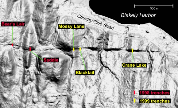
Five backhoe trenches were recently dug across a newly discovered scarp along the Toe Jam fault, a small fault within the Seattle fault zone. Some questions that we hope to answer through study of the sediments in the trenches include: How many large earthquakes have occurred on the Seattle fault since the Puget glacier lobe retreated into Canada 16,000 years ago? How large (magnitude 6 or 7?) were the earthquakes? Did several earthquakes occur over a short span of time, or were the earthquakes spaced evenly in time over many thousands of years? When was the last large earthquake on this part of the Seattle fault?
Most of
our radiocarbon samples are
still being analyzed and
we have not yet finished
our study of fossils, sediment
samples, and drawings made
of the faulted sediments
in the trenches. However,
some preliminary conclusions
about the Toe Jam fault include:
the trenches show a long history of folding
and faulting during earthquakes
over tens of thousands to
millions of years; the fault
slipped during at least one
large earthquake soon after
the glacier left; so far,
we have found only inconclusive
evidence about possible
earthquakes between 16,000
and a few thousand years
ago; the most recent earthquake
identified in at least four
of the five trenches is the
AD 900 earthquake, discovered
in 1992 through study of
uplifted shorelines and tsunami-deposited
sand; and perhaps two or
three earlier earthquakes
occurred in the few thousand
years preceding the earthquake
about AD 900.
show a long history of folding
and faulting during earthquakes
over tens of thousands to
millions of years; the fault
slipped during at least one
large earthquake soon after
the glacier left; so far,
we have found only inconclusive
evidence about possible
earthquakes between 16,000
and a few thousand years
ago; the most recent earthquake
identified in at least four
of the five trenches is the
AD 900 earthquake, discovered
in 1992 through study of
uplifted shorelines and tsunami-deposited
sand; and perhaps two or
three earlier earthquakes
occurred in the few thousand
years preceding the earthquake
about AD 900.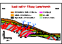
Many similar paleoseismology trenching studies are planned for other parts of the Seattle fault zone and other potentially hazardous faults in the region, such as the southern Whidbey Island fault zone, the northern Whidbey Island fault zone, and the Devils Mountain fault zone, as soon as laser imagery of these areas allows us to select the most productive sites for investigation.
Open file report available online
NELSON,
A.R., USGS, MS 966, Box 25046,
Denver CO 80225, anelson@usgs.gov,
303-273-8592;
JOHNSON, S.Y., USGS, MS 966,
Box 25046, Denver CO 80225;
PEZZOPANE, S.K., USGS, MS
425, Box 25046, Denver CO
80225;
WELLS, R.E., USGS, MS 975,
Menlo Park, CA 94025;
KELSEY, H.M., Dept. Geology,
Humboldt State Univ., Arcata,
CA 95521;
SHERROD, B.L., Dept. Geological
Sciences, Univ. Washington,
Seattle, WA
98195;
KOEHLER, R.D. III, William
Lettis & Associates,
Inc., Walnut Creek, CA;
BRADLEY, L-A., USGS, MS 966,
Box 25046, Denver CO 80225;
BUCKNAM, R.C., USGS, MS 966,
Box 25046, Denver CO 80225;
LAPRADE, W.T., Shannon &
Wilson, Inc., Seattle, WA
98103;
COX, J.W., USGS, MS 966,
Box 25046, Denver CO 80225,
Environmental Careers
Organization (USGS contractor);
and
NARWOLD, C.F., Dept. Geology,
Humboldt State Univ., Arcata,
CA 95521.
Recent Technical Abstracts
POSTGLACIAL AND LATE HOLOCENE EARTHQUAKES ON THE TOE JAM STRAND OF THE SEATTLE FAULT, BAINBRIDGE ISLAND, WASHINGTON
Abstract published by the Geological Society of America
(GSA Abstracts with Programs, v. n. p. ; presented at GSA Cordilleran Section Meeting, Vancouver, BC, 27-29 April 2000)
NELSON, A.R., USGS, MS 966, Box 25046, Denver CO 80225(1), anelson@usgs.gov; JOHNSON, S.Y., (1); PEZZOPANE, S.K., USGS, MS 425(1); WELLS, R.E., USGS, MS 975, Menlo Park, CA; KELSEY, H.M., Dept. Geology, Humboldt State Univ., Arcata, CA(2); SHERROD, B.L., Dept. Geological Sciences, Univ. Washington, Seattle, WA; KOEHLER, R.D. III, William Lettis & Associates, Inc., Walnut Creek, CA; BRADLEY, L-A., (1); BUCKNAM, R.C., (1); LAPRADE, W.T., Shannon & Wilson, Inc., Seattle, WA; COX, J.W., (1)Environmental Careers Organization (USGS contractor); and NARWOLD, C.F., (2).
Stratigraphy and structure exposed in five 14-to-30-m-long backhoe trenches across a south-facing scarp along the Toe Jam strand of the Seattle fault on southern Bainbridge Island indicate a minimum of three surface-faulting-and-folding earthquakes since the recession of the Puget ice lobe about 16 ka. In three trenches across 4-to-6-m-high scarps, Miocene bedrock has been steeply tilted, deeply weathered, highly fractured and faulted, and locally thrust southward over Quaternary deposits. Folding of proglacial lake beds of probable Vashon age in two trenches across 2-to-3-m-high scarps suggests postglacial deformation above a north-dipping, blind reverse fault. Although most 14C ages and retrodeformation analyses are pending, initial detrital charcoal ages from the trenches across 4-to-6-m-high scarps show that scarp colluvium and forest soils have been repeatedly faulted during the late Holocene. In one trench, ages from thrust-faulted soils and colluvium indicate at least two surface-faulting earthquakes since 2 ka. The youngest thrust in a second trench apparently slipped <3 ka. In a third trench, the initial charcoal age from soil caught in the structurally highest of five separate thrusts dates all thrusts at <1.4 ka, and structural relations apparently preclude formation of the thrusts during the same earthquake. A little-decayed cedar needle at the base of a 1-m-wide fissure in a fourth trench dates fissuring at <1.2 ka. In at least four of the five trenches, the latest faulting is probably coeval with the earthquake that caused dramatic uplift of a marine shoreline on Bainbridge Island 1100 years ago. Folding and uplift of wetland deposits in the trenches across 2-to-3-m-high scarps are the only potentially datable evidence of surface-deforming earthquakes that might date from the early or middle Holocene. If these events are in fact late Holocene, then no trenches show evidence of earthquakes during an interval that may be as long as 16 ka to 2 ka. (Access and support provided by Port Blakely Tree Farms, L.P., Seattle, www.portblakely.com/pbhome.htm)
A FAULT SCARP OF PROBABLE HOLOCENCE AGE IN THE SEATTLE FAULT ZONE, BAINBRIDGE ISLAND, WASHINGTON
Abstract published by Seismological Society of America (Seismological Research Letters, 1999, v. 70, p. 233)
Bucknam, R.C., U.S. Geological Survey, MS 966, Box 25046, Denver, CO 80225, bucknam@usgs.gov; Sherrod, Brian L., Department of Geological Sciences, University of Washington, Seattle WA 98195; and Elfendahl, Gerald, 7823 Westerly Lane NE, Bainbridge Island, WA 98110
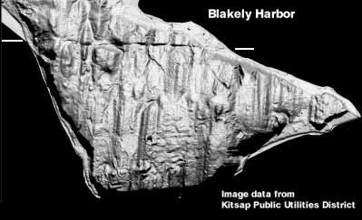
A recent aerial survey of Bainbridge Island done for the Kitsap Public Utility District, Washington, highlights a previously unrecognized lineament in the Seattle fault zone [Fig. 1]. The new laser technology used for the survey is effective in mapping the ground surface in heavily wooded areas. Digital shaded relief maps derived from the laser data show a sharply etched, nearly continuous, 2-km-long east-trending lineament crossing southern Bainbridge Island, 2.5 km south of Eagle Harbor. The lineament lies near and parallels one strand of the Seattle fault zone mapped by the U.S.G.S. from marine seismic reflection surveys. South-facing scarps along the lineament are 1.5 m to 10 m high. Relief along the lineament, which we infer to be a fault scarp, probably reflects cumulative offset during a series of surface-faulting earthquakes.
Southern Bainbridge Island is bordered by an uplifted Holocene marine platform formed during an earthquake 1100 years ago. Uplift from that earthquake extends at least 12 km south from the northernmost strand of the Seattle fault zone at Eagle Harbor to Dolphin Point on Vashon Island. The shoreline uplifted during the earthquake is commonly 5 to 7 meters above present high tide, but on the north, uplifted side of the lineament, beach gravel and a second uplifted shoreline are as much as 9 m above present high tide. This second shoreline suggests that some of the uplift north of the lineament is the result of fault slip along the lineament. No scarp similar to that along the lineament is visible on its projection on to the shoreline platform at Blakely Harbor or Rich Passage, and the lineament is truncated at the eroded shoreline at Blakely Harbor, suggesting that fault movement predates the earthquake 1100 years ago.
Airborne laser terrain map of southern Bainbridge Island. The sharply-etched feature that crosses the upper part of the image between the white lines is a late Holocene fault scarp. The vertical grooves are glacial striations.